Maps of Kings County
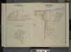
Queens, Vol. 2, Double Page Plate No. 27; Part of Ward Two St. Williamburgh; [Map bounded by Vermont Ave., Crosby Ave.; Including Highland Boulevard]; Part of Ward Two Nassau Hights; [Map bounded by Grand St., Maiden Lane, Firth Ave.; Including
from First and second wards: Long Island City and Newtown.
Queens V. 3, Plate No. 58 [Map bounded by Maurice Ave., Jackson Ave., Jefferson Ave., North Hempstead Plank Rd., Lexington Ave.]
From Atlas 137. Vol. 3, 1902.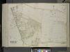
Queens, Vol. 2, Double Page Plate No. 40; Part of Ward Two Newtown; [Map bounded by Johnson Ave., Harbor Road, Furmanville Road; Including Juniper Swamp, Juniper Ave., Way St.]; Sub Plan; [Map bounded by Dry Harbor Road]
from First and second wards: Long Island City and Newtown.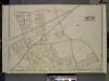
Queens, Vol. 2, Double Page Plate No. 22; Part of Ward Two Melvina; Maspeth, Linden Hill, East William Burg; [Map bounded by Maspeth Ave., Grand St., Flushing Ave., Fresh Pond Road; Including Mount Olivet Ave., Metropolitan Ave., Garrison A
from First and second wards: Long Island City and Newtown.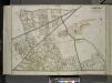
Queens, Vol. 2, Double Page Plate No. 32; Part of Ward Two Melvina Maspeth Linden Hill East Williamburgh; [Map bounded by Maspeth Ave., Grand St., Flushing Ave., Fresh Pond Road, Including Mount Olivet Ave., Metropolitan Ave., Grarrison Ave.,
from First and second wards: Long Island City and Newtown.
13B - N.Y. City (Aerial Set).
from Sectional aerial maps of the City of New York / [photographed and assembled under the direction of the chief engineer, July 1st, 1924].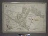
[Plate 7: Bounded by Maspeth Avenue, Maurice Avenue, Juniper Avenue, (Mount Olivet Cemetery) Fresh Pond Avenue, Metropolitan Avenue, Stanhope Street, Woodard Avenue,(Newtown Creek) Grand Street and Flushing Avenue.]
from Atlas of the city of New York, borough of Queens, Long Island City, Newtown, Flushing, Jamaica, Far Rockaway, from actual surveys and official plans / by George W. and Walter S. Bromley.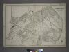
Part of the Borough of Queens, New town, Ward 2.
from Atlas of the city of New York, borough of Queens, Long Island City, Newtown, Flushing, Jamaica, Far Rockaway, from actual surveys and official plans / by George W. and Walter S. Bromley.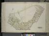
Queens, Vol. 2, Double Page Plate No. 28; Part of Ward Two Maspeth; [Map bounded by Maurice Ave., Fisk Ave., Grand St.; Including Maspeth Ave., Astoria Ave.]
from First and second wards: Long Island City and Newtown.
Queens, Vol. 2, Double Page Plate No. 38; Part of Ward Two Newtown; [Map bounded by Mt. Olivet Ave., Way Ave., Juniper Ave.; Including Metropolitan Ave., Fresh Pond Road.]
from First and second wards: Long Island City and Newtown.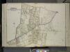
Queens, Vol. 2, Double Page Plate No. 27; Part of Ward Two Maspeth and Nassau Heights; [Map bounded by Calamus Road (Penny Bridge), Calamus Ave., grand St., North Hempstead Plank Road, Johnson Ave., Maiden Lane; Including Fulton St.,
from First and second wards: Long Island City and Newtown.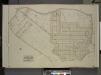
Queens, Vol. 2, Double Page Plate No. 19; Part of Ward Two Nassau Heights and Newtown Heights; [Map bounded by Grand St., Jamaica Ave., Trotting Course Lane; Including Wooley Ave., Johnson Ave., Maiden Lane]
from First and second wards: Long Island City and Newtown.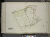
Queens, Vol. 2, Double Page Plate No. 31; Part of Ward two Newtown; [Map bounded by Newtown Ave., Covert Ave. (Betts Ave.), Old Brook School Road, Maurice Ave.; Including Astoria Ave., Maspeth Ave., Road to Town Landing, Berlin Ave.]
from First and second wards: Long Island City and Newtown.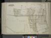
Queens, Vol. 2, Double Page Plate No. 39; Part of Ward Two Middle Village; [Map bounded by Juniper Swamp Road, Furmanville Road, Dry Harbor Road, Washington Ave., Cooper Ave., Haverramp St., Ford Ave.; Including Fulton Ave., St. Main Ave
from First and second wards: Long Island City and Newtown.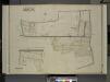
Queens, Vol. 2, Double Page Plate No. 26; Part of Ward Two Middle Village; [Map bounded by Juniper Swamp Road, Furmanville Road, Dryharbor Road, Washington Road; Including Cooper Ave., Barnum Ave., Metropolitan Ave., Juniper Ave.]; W
from First and second wards: Long Island City and Newtown.
Height District Map Section No. 13; Height district map / City of New York, Board of Estimate and Apportionment.
from Height district map / City of New York, Board of Estimate and Apportionment. New York (N.Y.). Board of Estimate and Apportionment,
Key
From Atlas 137a. Vol. 3, 1914.
Liqordom in New York City.
From Manhattan
Plate 40: Bounded by Corlears Street, Pierhead Line [Piers 45-1], Battery Park, Whitehall Street, and South Street.
from Atlas of the borough of Manhattan, city of New York.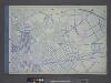
Use District Map Section No. 13
from Use district map / City of New York, Board of Estimate and Apportionment.
Area Zoning Map Section No. 13
From Area zoning map of the city of New York, compiled in the Dept. of City Planning, Division of Mapping and Zoning, May 27, 1953. Irving F. Ashworth, senior civil engineer.
Area District Map Section No. 13
from Area district map / City of New York, Board of Estimate and Apportionment.
Maspeth, Sunnyside, Woodside. (cont.)
From District 2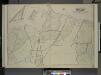
Queens, Vol.2, Double Page Plate No. 29; Part of Ward Two Newtown (East Williamsburgh, Melina and Nassau Heights); [Map bounded by Rotting Course Lane, Dry Harbor Road, Boundary between the Boroughs of Queens and Brooklyn, Newtown Creek, Bradle
from First and second wards: Long Island City and Newtown.
Plan of the city of Brooklyn, L.I. / by William Perris.
from Brooklyn
Bushwick, Ridgewood. (cont.)
From District 4
Plan of the city of Brooklyn, L.I. / by William Perris.
from Brooklyn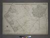
Part of the Borough of Queens, New town, Ward 2.
from Atlas of the city of New York, borough of Queens, Long Island City, Newtown, Flushing, Jamaica, Far Rockaway, from actual surveys and official plans / by George W. and Walter S. Bromley.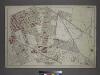
Part of the Borough of Queens, New town, Ward 2.
from Atlas of the city of New York, borough of Queens, Long Island City, Newtown, Flushing, Jamaica, Far Rockaway, from actual surveys and official plans / by George W. and Walter S. Bromley.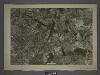
![Queens, Vol. 2, Double Page Plate No. 27; Part of Ward Two St. Williamburgh; [Map bounded by Vermont Ave., Crosby Ave.; Including Highland Boulevard]; Part of Ward Two Nassau Hights; [Map bounded by Grand St., Maiden Lane, Firth Ave.; Including](https://images-2.georeferencer.com/images/iiif/769202258462/full/,300/0/native.jpg)

