Maps of Kings County

Plate 40: Bounded by Corlears Street, Pierhead Line [Piers 45-1], Battery Park, Whitehall Street, and South Street.
from Atlas of the borough of Manhattan, city of New York.
Liqordom in New York City.
From Manhattan
Area District Map Section No. 13
from Area district map / City of New York, Board of Estimate and Apportionment.
Use District Map Section No. 13
from Use district map / City of New York, Board of Estimate and Apportionment.
Area Zoning Map Section No. 13
From Area zoning map of the city of New York, compiled in the Dept. of City Planning, Division of Mapping and Zoning, May 27, 1953. Irving F. Ashworth, senior civil engineer.
Height District Map Section No. 13; Height district map / City of New York, Board of Estimate and Apportionment.
from Height district map / City of New York, Board of Estimate and Apportionment. New York (N.Y.). Board of Estimate and Apportionment,
Map of the City of Williamsburg and town of Bushwick, inclu. Greenpoint with part of the City of Brooklyn
From Brooklyn
Plan of the city of Brooklyn, L.I. / by William Perris.
from Brooklyn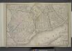
Brooklyn, Double Page Section 1; [Including wards 13, 14, 15, 16, 17, 18, 19]
from Farm line map of the city of Brooklyn, from official records and surveys; comp. and drawn by Henry Fulton.
Plan of the city of Brooklyn, L.I. / by William Perris.
from Brooklyn
A new map of the city of New York : comprising all the late improvements, compiled and corrected from authentic documents, designed to accompany the Description of New York.
from Manhattan
Sheet 7: Map encompassing Williamsburg, E. Williamsburg and Bushwick.
from Map of the city of Brooklyn : being the former cities of Brooklyn & Williamsburgh and the town of Bushwick, as consolidated January 1st, 1855 by an act of the legislature of the State of New York ... showing also a part of the City of New York.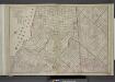
Brooklyn, Double Page Section 4; [Including Wards 16, 18, 19, 21, 25]
from Farm line map of the city of Brooklyn, from official records and surveys; comp. and drawn by Henry Fulton.
A new map of the city of New York : comprising all the late improvements, compiled and corrected from authentic documents.
from Manhattan
City of New York
1 : 29000 Breese, S.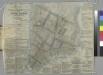
Hooker's new pocket plan of the city of New York / compiled & surveyed by William Hooker, engraver, No. 179 Water Street, New York, house, Willoughby St., Brooklyn.
From Manhattan
Plan of the city of Brooklyn, L.I. / by William Perris.
from Brooklyn
A new & accurate plan of the city of New York in the state of New York in North America, published in 1797.
from Manhattan
City Of New York.
1 : 17000 Tanner, Henry S.
Plan von New-York
Grosser Hand-Atlas über alle Theile der Erde in 170 Karten Meyer, J. Verlag des Bibliographischen Instituts
Plan of the city of New-York / drawn from actual survey by C[a]simir Th. [G]oerck, and Joseph Fr. Mangin, city surveyors.
from Manhattan
Sheet 8: Map encompassing Greenpoint and North Williamsburg.
from Map of the city of Brooklyn : being the former cities of Brooklyn & Williamsburgh and the town of Bushwick, as consolidated January 1st, 1855 by an act of the legislature of the State of New York ... showing also a part of the City of New York.
A map of the village of Williamsburgh, Kings County, N.Y. : showing each lot of ground in said village, as laid down on the assessment of the village, together with the assessment number of each lot / made by Isaac [V]ieth, under the supervision of Henry
from Brooklyn
Area District Map Section No. 12; Area district map / City of New York, Board of Estimate and Apportionment.
from Area district map / City of New York, Board of Estimate and Apportionment. New York (N.Y.). Board of Estimate and Apportionment,
Plan von der Stadt New York
1 : 68500 New York (New York)
The city of New York drawn from actual surveys as furnished by the several city surveyors
1 : 2350 [s.n.]
Plan of the city of New-York : the greater part from actual survey made expressly for the purpose (the rest from authentic documents) / by Thos. H. Poppleton, city surveyor ; P. Maverick sc. Newark.
from Manhattan
Plan of the city of New-York : the greater part from actual survey made expressly for the purpose (the rest from authentic documents) / by Thos. H. Poppleton, city surveyor ; P. Maverick sc. Newark.
from Manhattan
Plan of the city of New-York : with the recent and intended improvements / drawn from actual survey by William Bridges, city surveyor, A.D. 1807 ; engraved by Peter Maverick.
from Manhattan
![Plate 40: Bounded by Corlears Street, Pierhead Line [Piers 45-1], Battery Park, Whitehall Street, and South Street.](https://images-2.georeferencer.com/images/iiif/021295498318/full/,300/0/native.jpg)

