Maps of Queens County
Part of the Borough of Queens, New town, Ward 2.
from Atlas of the city of New York, borough of Queens, Long Island City, Newtown, Flushing, Jamaica, Far Rockaway, from actual surveys and official plans / by George W. and Walter S. Bromley.
13B - N.Y. City (Aerial Set).
from Sectional aerial maps of the City of New York / [photographed and assembled under the direction of the chief engineer, July 1st, 1924].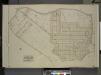
Queens, Vol. 2, Double Page Plate No. 19; Part of Ward Two Nassau Heights and Newtown Heights; [Map bounded by Grand St., Jamaica Ave., Trotting Course Lane; Including Wooley Ave., Johnson Ave., Maiden Lane]
from First and second wards: Long Island City and Newtown.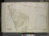
Queens, Vol. 2, Double Page Plate No. 40; Part of Ward Two Newtown; [Map bounded by Johnson Ave., Harbor Road, Furmanville Road; Including Juniper Swamp, Juniper Ave., Way St.]; Sub Plan; [Map bounded by Dry Harbor Road]
from First and second wards: Long Island City and Newtown.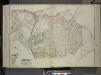
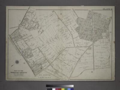
Queens, Vol. 2, Double Page Plate No. 26; Part of Ward two Nassau Heights and Newtown Heights; [Map bounded by Broadway, Court St., Horse Brook Road, Hoffman Boulevard, Trotting Course Lane, Dry Harbor, Hnson Ave., Bowne St., Corinth PL.;
from First and second wards: Long Island City and Newtown.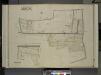
Queens, Vol. 2, Double Page Plate No. 26; Part of Ward Two Middle Village; [Map bounded by Juniper Swamp Road, Furmanville Road, Dryharbor Road, Washington Road; Including Cooper Ave., Barnum Ave., Metropolitan Ave., Juniper Ave.]; W
from First and second wards: Long Island City and Newtown.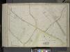
Queens, Vol. 2, Double Page Plate No. 41; Part of Ward Two Newtown; [Map bounded by Trotting Course Lane, Remsen St. (North Hempstead Road), White Pot Road; Including Cooper Road, Middle Village Road (Juniper Swamp Road), Dry Harbor Ro
from First and second wards: Long Island City and Newtown.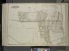
Queens, Vol. 2, Double Page Plate No. 39; Part of Ward Two Middle Village; [Map bounded by Juniper Swamp Road, Furmanville Road, Dry Harbor Road, Washington Ave., Cooper Ave., Haverramp St., Ford Ave.; Including Fulton Ave., St. Main Ave
from First and second wards: Long Island City and Newtown.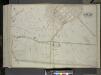
Queens, Vol. 2, Double Page Plate No. 48; Part of Ward Two Newtown; [Map bounded by Court St., Marlowe Ave., Romolus St., Otis Ave., Rehan PL.; Including North Hempstead Plank Road, Astoria Road, Hoffman Boulevard, Remsen St. (North Hempst
from First and second wards: Long Island City and Newtown.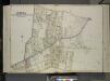
Queens, Vol. 2, Double Page Plate No. 27; Part of Ward Two Maspeth and Nassau Heights; [Map bounded by Calamus Road (Penny Bridge), Calamus Ave., grand St., North Hempstead Plank Road, Johnson Ave., Maiden Lane; Including Fulton St.,
from First and second wards: Long Island City and Newtown.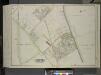
Queens, Vol. 2, Double Page Plate No. 42; Part of Ward Two Newtown; [Map bounded by Trotting Course Lane, Poplar Ave., Hazel Ave., Spruce Ave., Larch Ave.; Including Myrtle Ave., Thompson Ave., Dry Harbar Road, Metropolitan Ave.]
from First and second wards: Long Island City and Newtown.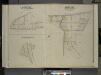
Queens, Vol. 2, Double Page Plate No. 27; Part of Ward Two St. Williamburgh; [Map bounded by Vermont Ave., Crosby Ave.; Including Highland Boulevard]; Part of Ward Two Nassau Hights; [Map bounded by Grand St., Maiden Lane, Firth Ave.; Including
from First and second wards: Long Island City and Newtown.
Queens V. 10, Plate No. 72 [Map bounded by Chicago St., Lewis Ave., Queens Blvd., Broadway, Horton]
From Atlas 148, Vol. 10, 1914.
Queens V. 3, Plate No. 119 [Map bounded by Hoffman Blvd., Hillside, Simpson St., Barnum Ave.]
From Atlas 137. Vol. 3, 1902.
Key Continued
From Atlas 137a. Vol. 3, 1914.
Height District Map Section No. 13; Height district map / City of New York, Board of Estimate and Apportionment.
from Height district map / City of New York, Board of Estimate and Apportionment. New York (N.Y.). Board of Estimate and Apportionment,
Part of the Borough of Queens, New town, Ward 2.
from Atlas of the city of New York, borough of Queens, Long Island City, Newtown, Flushing, Jamaica, Far Rockaway, from actual surveys and official plans / by George W. and Walter S. Bromley.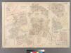
Plate 21: Village of Newtown, Town of Newtown. - Village of Maspeth, Town of Newtown. - Villages if Woodside and Charlotteville, Town of Newtown. - Village of Malvina, Town of Newtown. - Village of Winfield, Town of Newtown. - Village of Laurel Hill, Tow
from Atlas of Queens Co., Long Island, New York / compiled from official records, private plans & actual surveys by and under the direction of Chester Wolverton.
14A - N.Y. City (Aerial Set).
from Sectional aerial maps of the City of New York / [photographed and assembled under the direction of the chief engineer, July 1st, 1924].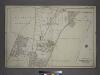
Part of the Borough of Queens, New town, Ward 2.
from Atlas of the city of New York, borough of Queens, Long Island City, Newtown, Flushing, Jamaica, Far Rockaway, from actual surveys and official plans / by George W. and Walter S. Bromley.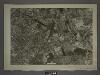
13D - N.Y. City (Aerial Set).
from Sectional aerial maps of the City of New York / [photographed and assembled under the direction of the chief engineer, July 1st, 1924].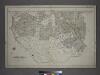
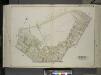
[Plate 14: Bounded by Railroad Avenue, Myrtle Avenue, Corona Avenue, North Hempstead Plank Road, Hoffman Boulevard, Jamaic Avenue and Broadway.]
from Atlas of the city of New York, borough of Queens, Long Island City, Newtown, Flushing, Jamaica, Far Rockaway, from actual surveys and official plans / by George W. and Walter S. Bromley.
Part of the Borough of Queens, New town, Ward 2.
from Atlas of the city of New York, borough of Queens, Long Island City, Newtown, Flushing, Jamaica, Far Rockaway, from actual surveys and official plans / by George W. and Walter S. Bromley.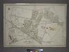
[Plate 7: Bounded by Maspeth Avenue, Maurice Avenue, Juniper Avenue, (Mount Olivet Cemetery) Fresh Pond Avenue, Metropolitan Avenue, Stanhope Street, Woodard Avenue,(Newtown Creek) Grand Street and Flushing Avenue.]
from Atlas of the city of New York, borough of Queens, Long Island City, Newtown, Flushing, Jamaica, Far Rockaway, from actual surveys and official plans / by George W. and Walter S. Bromley.
Newtown, Tn. of Newtown, Queens Co.
from Atlas of Long Island, New York. From recent and actual surveys and records.
Queens, Vol. 2, Double Page Plate No. 38; Part of Ward Two Newtown; [Map bounded by Mt. Olivet Ave., Way Ave., Juniper Ave.; Including Metropolitan Ave., Fresh Pond Road.]
from First and second wards: Long Island City and Newtown.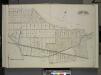
Queens, Vol. 2, Double Page Plate No. 25; Part of Ward Two Clendale and St. James Park; [Map bounded by Long Island Rail Road, Morris Ave., Fulton Ave., Myrtle Ave.; Including Cooper Ave., Fresh Pond Road, Sherman St.]
from First and second wards: Long Island City and Newtown.
Queens V. 3, Plate No. 58 [Map bounded by Maurice Ave., Jackson Ave., Jefferson Ave., North Hempstead Plank Rd., Lexington Ave.]
From Atlas 137. Vol. 3, 1902.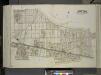
Queens, Vol. 2, Double Page Plate No. 37; Part of Ward Two Glendale and St. James Park; [Map bounded by Sherman St., Slocum St., Howard St., Sheridan St., Sigel St., Hooker St., Hancock St., Thomas St., Meade St., Folsom Ave., Fosdick Ave., Tom
from First and second wards: Long Island City and Newtown.