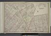
Maps of Kings County

Bushwick, Ridgewood. (cont.)
From District 4
Map of the city of Brooklyn, as laid out by commissioners, and confirmed by acts of the Legislature of the state of New York : made from actual surveys, the farm lines and names of original owners, being accurately drawn from authentic sources, contai...
From Brooklyn
Insurance Maps of the Brooklyn city of New York Volume Five. Published by the Sanborn map co. 117, Broadway, New York. 1888.
From Atlas 77. Vol. 5, 1888.
Area District Map Section No. 13
from Area district map / City of New York, Board of Estimate and Apportionment.
Area Zoning Map Section No. 13
From Area zoning map of the city of New York, compiled in the Dept. of City Planning, Division of Mapping and Zoning, May 27, 1953. Irving F. Ashworth, senior civil engineer.
Use District Map Section No. 13
from Use district map / City of New York, Board of Estimate and Apportionment.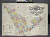
Insurance Maps of the Brooklyn city of New York Volume Seven. Published by the Sanborn map co. 117, Broadway, New York. 1888.
From Atlas 83. Vol. 7, 1888.
Plan of the city of Brooklyn, L.I. / by William Perris.
from Brooklyn
Key
From Atlas 137a. Vol. 3, 1914.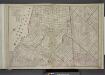
Brooklyn, Double Page Section 4; [Including Wards 16, 18, 19, 21, 25]
from Farm line map of the city of Brooklyn, from official records and surveys; comp. and drawn by Henry Fulton.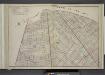
Brooklyn, Double Page Section 7; [Including Wards 18, 24, 25]
from Farm line map of the city of Brooklyn, from official records and surveys; comp. and drawn by Henry Fulton.
Plan of the city of Brooklyn, L.I. / by William Perris.
from Brooklyn
Area Zoning Map Section No. 17
From Area zoning map of the city of New York, compiled in the Dept. of City Planning, Division of Mapping and Zoning, May 27, 1953. Irving F. Ashworth, senior civil engineer.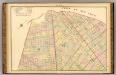
Sec. 7. Brooklyn map.
1 : 6000 Fulton, Henry; J.B. Beers & Co.
Sheet 7: Map encompassing Williamsburg, E. Williamsburg and Bushwick.
from Map of the city of Brooklyn : being the former cities of Brooklyn & Williamsburgh and the town of Bushwick, as consolidated January 1st, 1855 by an act of the legislature of the State of New York ... showing also a part of the City of New York.
[Sheet 3: Map encompassing Bedford Stuyvesant, Crown Heights and Weeksville.]
from Map of the city of Brooklyn : being the former cities of Brooklyn & Williamsburgh and the town of Bushwick, as consolidated January 1st, 1855 by an act of the legislature of the State of New York ... showing also a part of the City of New York.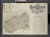
Insurance Maps of the Brooklyn city of New York Volume Four. Published by the Sanborn map co. 117, Broadway, New York. 1887.
From Atlas 74. Vol. 4, 1887.
Williamsburg, Greenpoint. (cont.)
From District 1
Liqordom in New York City.
From Manhattan
Sheet 4: Map encompassing Ocean Hill, Broasway Junction, Bushwick and Ridgewood.
from Map of the city of Brooklyn : being the former cities of Brooklyn & Williamsburgh and the town of Bushwick, as consolidated January 1st, 1855 by an act of the legislature of the State of New York ... showing also a part of the City of New York.
Plan of the city of Brooklyn, L.I. / by William Perris.
from Brooklyn
Area District Map Section No. 17; Area district map / City of New York, Board of Estimate and Apportionment.
from Area district map / City of New York, Board of Estimate and Apportionment. New York (N.Y.). Board of Estimate and Apportionment,
Use District Map Section No. 17; Use district map / City of New York, Board of Estimate and Apportionment.
from Use district map / City of New York, Board of Estimate and Apportionment. New York (N.Y.). Board of Estimate and Apportionment,
Height District Map Section No. 17; Height district map / City of New York, Board of Estimate and Apportionment.
from Height district map / City of New York, Board of Estimate and Apportionment. New York (N.Y.). Board of Estimate and Apportionment,
Height District Map Section No. 13; Height district map / City of New York, Board of Estimate and Apportionment.
from Height district map / City of New York, Board of Estimate and Apportionment. New York (N.Y.). Board of Estimate and Apportionment,
A map of the village of Williamsburgh, Kings County, N.Y. : showing each lot of ground in said village, as laid down on the assessment of the village, together with the assessment number of each lot / made by Isaac [V]ieth, under the supervision of Henry
from Brooklyn
Plan of the city of Brooklyn, L.I. / by William Perris.
from Brooklyn
Plan of the city of Brooklyn, L.I. / by William Perris.
from Brooklyn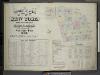
Insurance Maps of The City of New York Surveyed and Published by Perris & Browne 55 Liberty St. Volume Two. 1868.; Street Index.
from Insurance maps of the city of New York.