Maps of Kings County
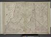
Brooklyn, Double Page Section 4; [Including Wards 16, 18, 19, 21, 25]
from Farm line map of the city of Brooklyn, from official records and surveys; comp. and drawn by Henry Fulton.
Sheet 7: Map encompassing Williamsburg, E. Williamsburg and Bushwick.
from Map of the city of Brooklyn : being the former cities of Brooklyn & Williamsburgh and the town of Bushwick, as consolidated January 1st, 1855 by an act of the legislature of the State of New York ... showing also a part of the City of New York.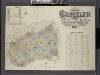
Insurance Maps of the Brooklyn city of New York Volume Four. Published by the Sanborn map co. 117, Broadway, New York. 1887.
From Atlas 74. Vol. 4, 1887.
Key
From Atlas 137a. Vol. 3, 1914.
Plan of the city of Brooklyn, L.I. / by William Perris.
from Brooklyn
Height District Map Section No. 13; Height district map / City of New York, Board of Estimate and Apportionment.
from Height district map / City of New York, Board of Estimate and Apportionment. New York (N.Y.). Board of Estimate and Apportionment,
13C - N.Y. City (Aerial Set).
from Sectional aerial maps of the City of New York / [photographed and assembled under the direction of the chief engineer, July 1st, 1924].
A map of the village of Williamsburgh, Kings County, N.Y. : showing each lot of ground in said village, as laid down on the assessment of the village, together with the assessment number of each lot / made by Isaac [V]ieth, under the supervision of Henry
from Brooklyn
Plan of the city of Brooklyn, L.I. / by William Perris.
from Brooklyn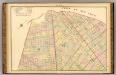
Sec. 7. Brooklyn map.
1 : 6000 Fulton, Henry; J.B. Beers & Co.
Plan of the city of Brooklyn, L.I. / by William Perris.
from Brooklyn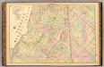
Sec. 4. Brooklyn map.
1 : 6000 Fulton, Henry; J.B. Beers & Co.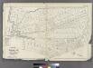
[Plate 30: Bounded by Seneca Avenue, Covert Street, Suydam Street, Cypress Avenue, Harman Street, St. Nicholas Avenue, Grove Street, Myrtle Avenue, Ralph Street, Knickerbocker Avenue, Bleecker Street, Hamburg Avenue, Harman Street, Central Avenue, Flushi
from Atlas of the entire city of Brooklyn, complete in one volume. From actual surveys and official records by G. W. Bromley & Co.
13A - N.Y. City (Aerial Set).
from Sectional aerial maps of the City of New York / [photographed and assembled under the direction of the chief engineer, July 1st, 1924].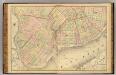
Sec. 1. Brooklyn map.
1 : 6000 Fulton, Henry; J.B. Beers & Co.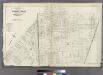
[Plate 32: Bounded by Greene Avenue, Bushvick Avenue, Himrod Street, Centrat Avenue, Greene Avenue, Myrtle Avenue, Bleecker Street, Wyckoff Avenue, Cornelia Street, Irving Avenue, Eldert Street, Knickerbocker Avenue, Schaffer Street, Broadway, Hopkinson
from Atlas of the entire city of Brooklyn, complete in one volume. From actual surveys and official records by G. W. Bromley & Co.
Map of the City of Williamsburg and town of Bushwick, inclu. Greenpoint with part of the City of Brooklyn
From Brooklyn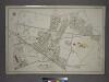
[Plate 7: Bounded by Maspeth Avenue, Maurice Avenue, Juniper Avenue, (Mount Olivet Cemetery) Fresh Pond Avenue, Metropolitan Avenue, Stanhope Street, Woodard Avenue,(Newtown Creek) Grand Street and Flushing Avenue.]
from Atlas of the city of New York, borough of Queens, Long Island City, Newtown, Flushing, Jamaica, Far Rockaway, from actual surveys and official plans / by George W. and Walter S. Bromley.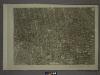
17A - N.Y. City (Aerial Set).
from Sectional aerial maps of the City of New York / [photographed and assembled under the direction of the chief engineer, July 1st, 1924].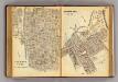
168-169 Sherman Park.
1 : 7200 G.W. Bromley & Co.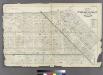
Plate 29: Bounded by Flushing Avenue, Central Avenue, Himrod Street, Evergreen Avenue, Harman Street, Bushwick Street, Greene Street, Broadway, Lexington Avenue and Nostrand Avenue.
from Atlas of the entire city of Brooklyn, complete in one volume. From actual surveys and official records by G. W. Bromley & Co.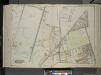
Queens, Vol. 2, Double Page Plate No. 33; Part of Ward Two Newtown; [Map bounded by Flushing Ave., Union Ave., Carrison Ave., Flushing Ave., Metropolitan Ave.; Including Stanhope St. (Summit St.), Boundary Line between boroughs of Queens and
from First and second wards: Long Island City and Newtown.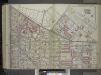
Brooklyn, Vol. 1, 2nd Part, Double Page Plate No. 38; Part of Wards 18 & 27, Section 10-11; [Map bounded by Flushing Ave., Morgan Ave., Meserole St., Gardner Ave.; Including Johnson Ave., Cypress Ave., De Kalb Ave., Broadway]; Sub Plan [Map bounded by...
From Volume 1
Part of Wards 18 & 27. Land Map Sections, Nos. 18 & 27. Volume 1, Brooklyn Borough, New York City.
from Atlas of the Brooklyn borough of the City of New York : originally Kings Co.; complete in three volumes ... based upon official maps and plans ... / by and under the supervision of Hugo Ullitz, C.E.
Plate 17: Bounded by Flushing Avenue, Knickerbocker Avenue, Grattan Street, Flushing Avenue, Covert Avenue, Myrtle Avenue, Cypress Street, Standhope Street, St. Nicholas Avenue, Harman Street, Bushwick Avenue and Bremen Street.
from Robinson's atlas of the city of Brooklyn, New York : embracing all territory within its corporate limits; from official records ... / by and under the supervision of E. Robinson and R.H. Pidgeon, civil engineers.
Part of Wards 27 & 28. Land Map Section, No. 11, Volume 1, Brooklyn Borough, New York City.
from Atlas of the Brooklyn borough of the City of New York : originally Kings Co.; complete in three volumes ... based upon official maps and plans ... / by and under the supervision of Hugo Ullitz, C.E.
Plate 21: Part of Ward 18. Brooklyn, N.Y.
from Atlas of the city of Brooklyn, New York.
Part of Wards 14, 15 & 17. Land Map Sections, No. 8 & 9, Volume 1, Brooklyn Borough, New York City.
from Atlas of the Brooklyn borough of the City of New York : originally Kings Co.; complete in three volumes ... based upon official maps and plans ... / by and under the supervision of Hugo Ullitz, C.E.
Double Page Plate No. 32: [Bounded by Marcy Ave., Metropolitan Ave., N. Fifth St., Havemeyer St., Withers St., Union Ave., Richardson St., Leonard St., Frost St., Manhattan Ave., Withers St., Graham Ave., Jackson St., Humboldt St., Metropolitan Ave., Bus
from Atlas of the Brooklyn borough of the City of New York : originally Kings Co.; complete in three volumes ... based upon official maps and plans ... / by and under the supervision of Hugo Ullitz, C.E.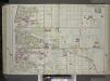
![Brooklyn, Double Page Section 4; [Including Wards 16, 18, 19, 21, 25]](https://images-2.georeferencer.com/images/iiif/203580589312/full/,300/0/native.jpg)

