Maps of Kings County

Plan of the city of Brooklyn, L.I. / by William Perris.
from Brooklyn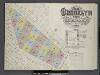
Insurance Maps of the Brooklyn city of New York Volume Five. Published by the Sanborn map co. 117, Broadway, New York. 1888.
From Atlas 77. Vol. 5, 1888.
[Sheet 3: Map encompassing Bedford Stuyvesant, Crown Heights and Weeksville.]
from Map of the city of Brooklyn : being the former cities of Brooklyn & Williamsburgh and the town of Bushwick, as consolidated January 1st, 1855 by an act of the legislature of the State of New York ... showing also a part of the City of New York.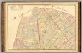
Sec. 7. Brooklyn map.
1 : 6000 Fulton, Henry; J.B. Beers & Co.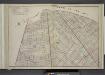
Brooklyn, Double Page Section 7; [Including Wards 18, 24, 25]
from Farm line map of the city of Brooklyn, from official records and surveys; comp. and drawn by Henry Fulton.
Area District Map Section No. 17; Area district map / City of New York, Board of Estimate and Apportionment.
from Area district map / City of New York, Board of Estimate and Apportionment. New York (N.Y.). Board of Estimate and Apportionment,
Use District Map Section No. 17; Use district map / City of New York, Board of Estimate and Apportionment.
from Use district map / City of New York, Board of Estimate and Apportionment. New York (N.Y.). Board of Estimate and Apportionment,
Height District Map Section No. 17; Height district map / City of New York, Board of Estimate and Apportionment.
from Height district map / City of New York, Board of Estimate and Apportionment. New York (N.Y.). Board of Estimate and Apportionment,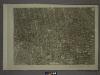
17A - N.Y. City (Aerial Set).
from Sectional aerial maps of the City of New York / [photographed and assembled under the direction of the chief engineer, July 1st, 1924].
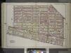
Plan of the city of Brooklyn, L.I. / by William Perris.
from Brooklyn
Plan of the city of Brooklyn, L.I. / by William Perris.
from Brooklyn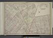
Brooklyn, Double Page Section 5; [Including Wards 7, 9, 20, 22, 23]
from Farm line map of the city of Brooklyn, from official records and surveys; comp. and drawn by Henry Fulton.
Brooklyn, Section 8; [Including Wards 24]
from Farm line map of the city of Brooklyn, from official records and surveys; comp. and drawn by Henry Fulton.
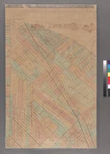
Sheet 4: Map encompassing Ocean Hill, Broasway Junction, Bushwick and Ridgewood.
from Map of the city of Brooklyn : being the former cities of Brooklyn & Williamsburgh and the town of Bushwick, as consolidated January 1st, 1855 by an act of the legislature of the State of New York ... showing also a part of the City of New York.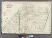
[Plate 32: Bounded by Greene Avenue, Bushvick Avenue, Himrod Street, Centrat Avenue, Greene Avenue, Myrtle Avenue, Bleecker Street, Wyckoff Avenue, Cornelia Street, Irving Avenue, Eldert Street, Knickerbocker Avenue, Schaffer Street, Broadway, Hopkinson
from Atlas of the entire city of Brooklyn, complete in one volume. From actual surveys and official records by G. W. Bromley & Co.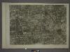
17C - N.Y. City (Aerial Set).
from Sectional aerial maps of the City of New York / [photographed and assembled under the direction of the chief engineer, July 1st, 1924].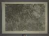
13C - N.Y. City (Aerial Set).
from Sectional aerial maps of the City of New York / [photographed and assembled under the direction of the chief engineer, July 1st, 1924].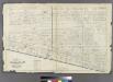
Plate 31: Part of Wards 23 & 25. City of Brooklyn.
from Atlas of the entire city of Brooklyn, complete in one volume. From actual surveys and official records by G. W. Bromley & Co.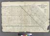
Plate 29: Bounded by Flushing Avenue, Central Avenue, Himrod Street, Evergreen Avenue, Harman Street, Bushwick Street, Greene Street, Broadway, Lexington Avenue and Nostrand Avenue.
from Atlas of the entire city of Brooklyn, complete in one volume. From actual surveys and official records by G. W. Bromley & Co.
Plate 37: Part of Ward 26. Brooklyn, N.Y.
from Atlas of the city of Brooklyn, New York.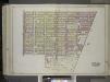
Brooklyn, Vol. 1, 2nd Part, Double Page Plate No. 40; Part of Ward 28, Section 11; [Map bounded by Cornelia St., Wyckoff Ave., Eldert St., Irving Ave.; Including Cemetery Lane, Granite St., Evergreen Ave., Moffatt St., Broadway] / by and under the dir...
From Volume 1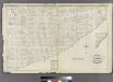
Plate 33: Part of Wards 23 & 25. City of Brooklyn.
from Atlas of the entire city of Brooklyn, complete in one volume. From actual surveys and official records by G. W. Bromley & Co.
Plate 21: Part of Ward 18. Brooklyn, N.Y.
from Atlas of the city of Brooklyn, New York.
Double Page Plate No. 40: [Bounded by Cornelia Street, Irving Avenue, Halsey Street, Knickerbocker Avenue, Chauncey Street, Hamburg Avenue, Granite Street, Evergreen Avenue, Cooper Street and Broadway.]
from Atlas of the Brooklyn borough of the City of New York : originally Kings Co.; complete in three volumes ... based upon official maps and plans ... / by and under the supervision of Hugo Ullitz, C.E.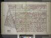
Brooklyn, Vol. 1, Double Page Plate No. 20; Part of Wards 24, 26 & 32, Sections 5-12; [Map bounded by Williams Ave., Riverdale Ave., Bristol St., East New York Ave.; Including Rockaway Ave., Atlantic Ave., East New York Ave.] / by and under the direct...
From Volume 1
Part of Wards 27 & 28. Land Map Section, No. 11, Volume 1, Brooklyn Borough, New York City.
from Atlas of the Brooklyn borough of the City of New York : originally Kings Co.; complete in three volumes ... based upon official maps and plans ... / by and under the supervision of Hugo Ullitz, C.E.
Plate 18: [Bounded by Flushing Avenue, Bremen Street, Bushwick Avenue, Willoughby Avenue, Broadway, Hart Street, Stuyvesant Avenue, Lafayette Avenue and Nostrand Avenue.]
from Atlas of the borough of Brooklyn, city of New York : from actual surveys and official plans by George W. and Walter S. Bromley.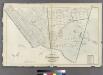
Plate 34: Part of Wards 23 & 25. City of Brooklyn.
from Atlas of the entire city of Brooklyn, complete in one volume. From actual surveys and official records by G. W. Bromley & Co.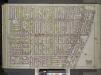
Brooklyn, Vol. 1, Double Page Plate No. 26; Part of Wards 7, 21 & 23, Sections 6 & 7; [Map bounded by Marcy Ave., Fulton St., New York Ave., Atlantic Ave.; Including Grand Ave., Lafayette Ave., Steuben St., Willoughby Ave.] / by and under the directio...
From Volume 1