Maps of Kings County

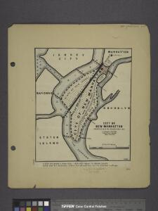
City of New Manhattan : proposed May 1911, revised May 1930 / T. Kennard Thomson, consulting engineer, New York City.
from Manhattan
Map of property situated in the 12th ward of the city of New York belonging to the estate of John Taylor : to be sold at auction by Jas. Bleecker & Sons at the Merchts. Exchange at 12 o'clock on Tuesday the 1st April 1834.
from Manhattan
Brooklyn, N.Y. Bay, Jersey City, Hoboken, Bayonne, Newark Bay.
1 : 31680 Vermeule, C. C. (Cornelius Clarkson), 1858-1950
Map of the consolidated city of Brooklyn, for Bishop's manual of the corporation.
From Brooklyn
General map of the city of New York, consisting of boroughs of Manhattan, Brooklyn, Bronx, Queens and Richmond : consolidated into one municipality by act of the legislature of the state of New York (Chapter 378 of the laws of 1897) : showing in addition
from Whole
Map of the Borough of Brooklyn Published for the Brooklyn Directory.
From Brooklyn
Map of the city of Brooklyn
From Brooklyn
Map of the consolidated city of Brooklyn.
From Brooklyn
Map of the Borough of Brooklyn showing location of racial colonies.
From Brooklyn
[Map of Brooklyn.]
From Brooklyn
The City of Brooklyn.
from Atlas of Long Island, New York. From recent and actual surveys and records.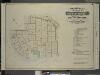
Index to Volume Six. Atlas of the Borough of Brooklyn. Sections 17, 18 & 19. Ward 30. City of New York. E. Belcher Hyde, 97 Liberty St., Brooklyn Borough. 1905.
from Ward 30.
Map of Kings County including the city of Brooklyn.
From Brooklyn
Brooklyn.
1 : 31000 Rand McNally and Company
City of New York, Borough of Brooklyn ; map showing section stations, stables, and dumps.
From Brooklyn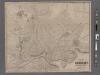
New map of the city of Brooklyn
From Brooklyn
Bath, Town on New Utrecht, Kings Co.
from Atlas of Long Island, New York. From recent and actual surveys and records.
Handy map of Brooklyn.
From Brooklyn
Map of Staten Island, Richmond County, New York City, from surveys under the direction of H. F. Walling.
From Staten Island
City & county map of New York, Brooklyn, Williamsburgh, Jersey City & the adjacent waters.
From Manhattan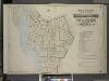
Index to Volume One, Atlas of the Borough of Brooklyn Sections 1, 2, 3 & 4. Wards 1, 2, 3, 4, 5, 6, 8, 9, 10, 12 & 22. City of New York. Published by E. Belcher Hyde, 97 Liberty St., Brooklyn. 1903.
from Wards 1, 2, 3, 4, 5, 6, 8, 9, 10, 12 & 22.
King's bird's-eye view of Brooklyn
From Brooklyn
Map of Brooklyn.
From Brooklyn
Guide map of the borough of Brooklyn, Kings County, New York.
From Brooklyn
Map of the cities of New York, Jersey City, Hoboken, with part of Brooklyn.
From Manhattan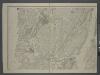
Map of New-York Bay and Harbor and the environs / founded upon a trigonometrical survey under the direction of F. R. Hassler, superintendent of the Survey of the Coast of the United States ; triangulation by James Ferguson and Edmund Blunt, assistants ;
from New York harbor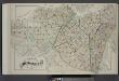
Index Map of Brooklyn
from Detailed estate and old farm line atlas of the city of Brooklyn : complete in six volumes ... from official records, private plans, and actual surveys ... / by G.M. Hopkins, C.E.
Guide map of Brooklyn, Kings County, N.Y. ....for Brooklyn daily eagle almanac.
From Brooklyn
Taunton's pocket edition of the merchant's and shipper's guide map to the port of New York / S.D.L. Taunton.
from Whole