Maps of Kings County

Guide map of Brooklyn, Kings County, N.Y. ....for Brooklyn daily eagle almanac.
From Brooklyn
Guide map of the borough of Brooklyn, Kings County, New York.
From Brooklyn
Map of Brooklyn.
From Brooklyn
City of New York, Borough of Brooklyn ; map showing section stations, stables, and dumps.
From Brooklyn
Map of the Borough of Brooklyn Published for the Brooklyn Directory.
From Brooklyn
[Map of Brooklyn.]
From Brooklyn
Map of the Borough of Brooklyn showing location of racial colonies.
From Brooklyn
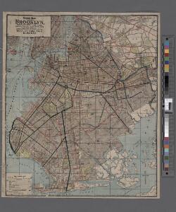
Map of Brooklyn, House Number and Subway Guide.
From Brooklyn
Brooklyn - Liberty Loan Committee - division of districts.
From Brooklyn
Map of the city of Brooklyn
From Brooklyn
New map of the city of Brooklyn
From Brooklyn
Map of the consolidated city of Brooklyn, for Bishop's manual of the corporation.
From Brooklyn
Map of the consolidated city of Brooklyn.
From Brooklyn
Brooklyn.
1 : 31000 Rand McNally and Company
Outline & Index Map of the City of Brooklyn, Kings County, N.Y.
from Robinson's atlas of the city of Brooklyn, New York : embracing all territory within its corporate limits; from official records ... / by and under the supervision of E. Robinson and R.H. Pidgeon, civil engineers.
Hudson County, V. 8, Double Page Plate No. 1 [Map bounded by Spring St., Cortland St., Hillside Rd., Paterson Plank Rd.] / surveyed and published by Chas. B. Brush. Vol. 8.
From Insurance maps of Hudson County, New Jersey
Index Map to Volume Two. Atlas of the Brooklyn Borough of the City of New York.
from Atlas of the Brooklyn borough of the City of New York : originally Kings Co.; complete in three volumes ... based upon official maps and plans ... / by and under the supervision of Hugo Ullitz, C.E.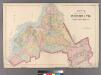
Plate 2: Map of the City of Brooklyn, Long Island, N.Y.
from Atlas of Queens Co., Long Island, New York / compiled from official records, private plans & actual surveys by and under the direction of Chester Wolverton.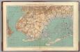
Narrows-Jamaica Bay, Brooklyn.
1 : 31680 Vermeule, C. C. (Cornelius Clarkson), 1858-1950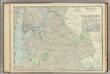
Brooklyn.
1 : 24500 Rand McNally and Company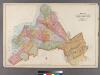
Plate 32: Map of the City of Brooklyn, Kings Co., N.Y.
from Robinson's atlas of Kings County, New York : compiled from official records ... / under the direction of E. Robinson.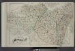
Index Map of Brooklyn
from Detailed estate and old farm line atlas of the city of Brooklyn : complete in six volumes ... from official records, private plans, and actual surveys ... / by G.M. Hopkins, C.E.
Handy map of Brooklyn.
From Brooklyn
Map of the borough of Brooklyn, City of New York.
From Brooklyn
King's bird's-eye view of Brooklyn
From Brooklyn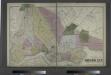
The City of Brooklyn.
from Atlas of Long Island, New York. From recent and actual surveys and records.
Map of Kings County including the city of Brooklyn.
From Brooklyn
Index Map to Volume One. Atlas of the Brooklyn Borough of the City of New York.
from Atlas of the Brooklyn borough of the City of New York : originally Kings Co.; complete in three volumes ... based upon official maps and plans ... / by and under the supervision of Hugo Ullitz, C.E.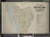
Index to Volume One, Atlas of the Borough of Brooklyn Sections 1, 2, 3 & 4. Wards 1, 2, 3, 4, 5, 6, 8, 9, 10, 12 & 22. City of New York. Published by E. Belcher Hyde, 97 Liberty St., Brooklyn. 1903.
from Wards 1, 2, 3, 4, 5, 6, 8, 9, 10, 12 & 22.