Maps of Appalachian Mountains
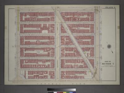
Plate 4: Part of Section 7.
from Atlas of the city of New York, borough of Manhattan / from actual surveys and official plans by George W. and Walter S. Bromley.
Ice Chart, Grand Banks Region, September, October.
U.S. Navy
Nova tabula geographica complectens borealiorem Americae partem : in qua exacte delineatae sunt Canada sive Nova Francia, Nova Scotia, Nova Anglia, Novum Belgium, Pensylvania, Virginia, Carolina et Terra Nova : cum omnibus littorum pulvinorumque profundi
from John H. Levine Collection
Shell Highway Map Northeastern Section of the United States.
1 : 3231360 Shell Oil Company
An accurate map of the English colonies in North America bordering on the River Ohio.
from Parts
Grand Trunk Ry. of Canada.
1 : 3362700 Grand Trunk Railway Company of Canada
Ice Chart, Grand Banks Region, March, April.
U.S. Navy
Ice Chart, Grand Banks Region, May, June.
U.S. Navy
Ice Chart, Grand Banks Region, November, December.
U.S. Navy
A new map of part of the United States of North America : containing those of New York, Vermont, New Hampshire, Massachusets, Connecticut, Rhode Island, Pennsylvania, New Jersey, Delaware, Maryland and Virginia from the latest authorities / by John Cary,
from Parts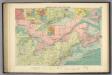
American Atlantic ports N.
1 : 5000000 Philip, George
Map of the Northern and Middle States.
1 : 6900000 Morse, Jedidiah
Ice Chart, Grand Banks Region, July, August.
U.S. Navy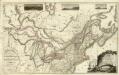
Composite: Upper, Lower Canada; United States &c.
1 : 2300000 Faden, William, 1750?-1836
A map of the northern and middle states

Die vereinigten Staaten von Nord-America: nach der von Wm. Faden 1783 herausgegebenen Charte, auf welcher alle im englisch americanischen Kriege vorzüglich merkwürdig gewordenen Örter angezeigt, auch die Grenzen zwischen Grosbrittanien, America und Spanien nach Maasgabe des Friedensschulusses von 1783 bestimmt sind / T. Marianus, Sculp., A.V.; Geschichte der Revolution von Nord-America.
from Geschichte der Revolution von Nord-America. Gegel, Ludwig Bernhard Friederich; Sprengel, M. C. (Matthias Christian),
Map of the Northern and Middle States.
1 : 6950000 Morse, Jedidiah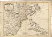
Carte des possessions angloises dans l'Amerique Septentrionale
1 : 3500000 Spojené státy americké-oblast východní Imbert, J. Leopold chez Mondhare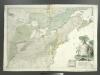
Theatrum belli in America Septentrionali: II. foliis comprehensum / jussu Acad[emiis] Reg[iis] Scient[iarum] et Eleg[antium] Litt[erarum] exhibet; I.C. Rhode Ac[ademiae?] Geogr[aphus?]; Berger, sculpsit Berol[ini].
from Parts Berol[ini].,
Skeleton map of the rail-roads between Cape Canso and St. Louis

Generalkarte von Nord America samt den westindischen Inseln
Severní Amerika Pownall Schraembl, Franz Anton F.A. Schraembl
New Map of Upper & Lower Canada.
1 : 130000000 Morse, Jedidiah
West-Indien, Central-Amerika bis zum südlichen Canada in 4 Blättern
1 : 7500000 Nordost-Blatt Petermann, August Heinrich ; Habenicht, H. Justus Perthes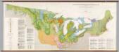
United States: East of the Rocky Mountains -- Glacial Deposits
1 : 1750000 The Geological Society of America
A new map of part of the United States of North America : containing those of New York, Vermont, New Hampshire, Massachusets, Connecticut, Rhode Island, Pennsylvania, New Jersey, Delaware, Maryland and Virginia from the latest authorities / by John Cary,
from Charts and maps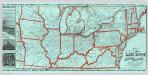
Lake Shore and Michigan So. Railway.
1 : 3431200 Lake Shore & Michigan Southern Railway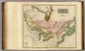
Canada, Nova Scotia.
1 : 4800000 Thomson, John
Die Atlantischen Staaten zwischen Washington & Boston, Blatt 2]
Adolf Stieler's Handatlas über alle Theile der Erde und über das Weltgebäude Stieler, Adolf Justus Perthes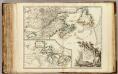
Nouvelle France ou le Canada.
1 : 4000000 Robert de Vaugondy, Gilles, 1688-1766