Maps of Appalachian Mountains
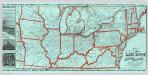
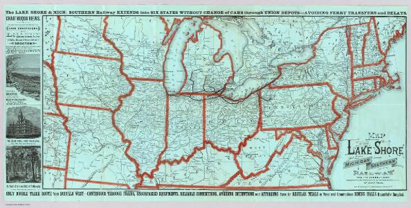
Lake Shore and Michigan So. Railway.
1 : 3431200 Lake Shore & Michigan Southern Railway
United States of North America (North East Sheet).
1 : 3984000 Johnston, W. & A.K.
British American, English, Welsh, Swedish, Norwegian population 1870.
1 : 14300000 United States. Census Office; Walker, Francis Amasa, 1840-1897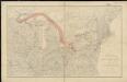
Distribution of the iron ores mined in the Lake Superior Region in year 1902
1 : 2500000 Birkinbine, John Geological Survey (U.S.)
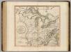
A map of the United States of America, as settled by the peace of 1783.
from Whole Publish[e]d by I. Fielding, Pater-noster Row: [London],
A map of the United States of America, as settled by the peace of 1783.
from Whole Publish[e]d ... by I. Fielding, Pater-noster Row: [London]; Andrews, John,
A new map of the United States including part of Louisiana

Map of the United States showing the land west of the Mississippi River still as Louisiana. Ohio is named as a state. Many Indian tribes and villages are named. A lead mine is located in today's northwestern Illinois. Florida is divided into the Spanish possessions of East and West Florida, Georgia extends to the Mississippi.

Map of the United States of America.
1 : 6500000 Winterbotham, W.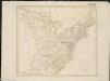
United States of America

Lines And Metallic Circuit Connections.
1 : 2155000 American Telephone and Telegraph Company
The United States of America, according to the Treaty of Peace of 1784 / Russell, del. et sculpt.
from Whole Russell,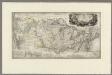
Map to illustrate the route of Prince Maximilian of Wied in ... North America.
1 : 4050000 Thorn, William
A New Map of the United States.
1 : 1520640 Carleton, Osgood
Etats Unis de l'Amérique
1 : 13000000 gravé par Tardieu corr. et augm. en 1803 [Paris] : [s.n.]
United States of Nth. America.
1 : 1584000 Tardieu, P.F.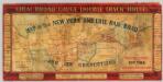
Map of the New York and Erie Rail Road and its connections.
1 : 3370000 New York And Erie Railway Company
United States Of North America.
1 : 1550000 Arrowsmith, Aaron
United States

United States of America / drawn & engraved for Wardens Statistical account by W. & D. Lizars, Edinburgh
1 : 6000000 Annotatie: Uit: A statistical, political, and historical account of the United States of North America ... / D.B. Warden. - Edinburgh : Constable, 1819 William Lizars; Daniel Lizars [Edinburgh : A. Constable & Co.]
United States of Nth. America = Carte des Etats-Unis de l'Amérique Septentrionale / copiée et gravée sur celle d'Arrowsmith; corrigée et considérablement augmentée d'après les renseignemens les plus authentiques par P.F. Tardieu, graveur, editeur-propriétaire, Place de l'Estrapade No. 1; ecrit par J.J. Pachoux; Chles. Picquet, géographe-graveur, Quai de la Monnaie No. 17.
from Charts and maps P.F. Tardieu; J. J. Pachoux; Charles Picquet,
Composite: United States of Nth. America.
1 : 1584000 Tardieu, P.F.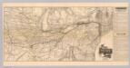
Map N.Y. Central & Hudson R. RR.
1 : 3104600 New York Central and Hudson River Railroad Company
United States of Nth. America = Carte des Etats-unis de l'Amérique septentrionale / copiée et gravée sur celle d'Arrowsmith; corrigée et considérablement augmentée d'après les renseignemens les plus authentiques par P.F. Tardieu, graveur, editeur-propriétaire, Place de l'Estrapade, No. 18. à Paris, an XL 1802; ecrit par J.J. Pachoux; Chles. Picquet, géographe-graveur ...
from Parts P.F. Tardieu; J. J. Pachoux; Charles Picquet,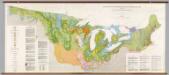
United States: East of the Rocky Mountains -- Glacial Deposits
1 : 1750000 The Geological Society of America
Map of the United States and British Provinces of Upper and Lower Canada.
1 : 1838000 Shelton, W.
States of America, drawn from the best authorities

Verein-Staaten von Nord-America mit Ausnahme Florida's und der westlichen Territoirien
Hand-Atlas über alle Theile der Erde nach dem neuesten Zustande und über das Weltgebäude Stieler, Adolf bei Justus Perthes
A new and general map of the middle dominions belonging to the United States of America: viz. Virginia, Maryland, the Delaware-counties, Pennsylvania, New Jersey &c. with the addition of New York, & of the greatest part of New England &c as also of the bordering parts of the British possessions in Canada.
from Parts Published by Laurie & Whittle, No. 53 Fleet Street ...: London; Robert Laurie and James Whittle,