Maps of New Jersey

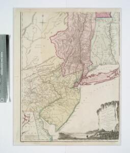
The provinces of New York, and New Jersey : with part of Pensilvania, and the governments of Trois Rivieres, and Montreal / drawn by Capt. Holland ; engraved by Thomas Jefferys, geographer to His Majesty.
from Parts
The provinces of New York, and New Jersey : with part of Pensilvania and the province of Quebec / drawn by Major Holland, Surveyor General of the Northern District in America ; corrected and improved, from the original materials, by Governr. Pownall, Mem
from Charts and maps
Kaart van Nieuw Nederland / [getekend door] R. van Wijk
Dordrecht : J. de Vos
Pensylvania Nova Jersey et Nova York cum Regionibus ad Fluvium Delaware in America sitis
1 : 1000000 Lotter, Tobias Conrad
The provinces of New York, and New Jersey; with part of Pensilvania, and the province of Quebec
1 : 700000 drawn by major Holland, surveyor general, of the Northern district in America corrected and improved from the original materials by govern.r Pownall, member of parliament London : printed for Rob.t Sayer & John Bennett [...]
A New and accurate map of New Jersey : from the best authorities.
from Whole
The provinces of New York and New Jersey, with part of Pensilvania, and the Province of Quebec
1 : 650000 Pownall, Thomas Robert Sayer & John Bennett (Firm)
New Iarsey / by John Seller.
from A new system of geography : designed in a most plain and easie method, for the better understanding that science : accommodated with new maps of all the empires, kingdoms, principalities, dukedoms, provinces, and countries in the whole world : with geographical tables, explaining the divisions in each map / by John Seller, late hydrographer to the King.
Map of Pennsylvania, New Jersey and Delaware compiled from the latest authorities.
from Parts Mitchell, S. Augustus (Samuel Augustus) -- Compiler,
A new mapp of East and West New Jarsey.
from The sea-atlas : containing an hydrographical description of most of the sea-coasts of the known parts of the world.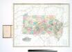
A map of the canals & rail roads of Pennsylvania and New Jersey, and the adjoining states / by H.S. Tanner; engraved by H.S. Tanner & assistants.
from Parts Henry S. Tanner,
Delaware, from the best authorities / W. Barker, sculp., Philada.
from Carey's American atlas.
A map of New Jersey, from the best authorities.
from The American geography; or, A view of the present situation of the United States of America: containing astronomical geography; geographical definitions, discovery, and general description ... By Jedidiah Morse, A.M.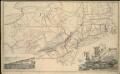
Map of the South Mountain and Boston Railroad & connections showing territory passed through, rail-roads and canals crossed or connected with, together with mineral and geographical features of country passed through

Map of the states of Pennsylvania and New Jersey / engraved & printed by Fenner Sears & Co.
from Parts Fenner Sears & Co.,
205. United States of America, Middle Atlantic. The World Atlas.
1 : 1250000 USSR (Union of Soviet Socialist Republics).
Pensylvania Nova Jersey et Nova York cum regionibus ad fluvium Delaware in America sitis, nova delineatione ob oculos posita
1 : 2200000 New Jersey Lotter, Tobias Conrad per Tob. Conr. Lotter
A chorographical map of the Province of New-York in North America, divided into counties, manors, patents and townships, exhibiting likewise all the private grants of land made and located in that Province
1 : 322000 Sauthier, Claude Joseph Faden, William
Map of the state of New York / by Simeon De Witt, surveyor general ; engraved by G. Fairman.
from Whole
North America 1:1,000,000
1 : 1000000 Hudson (New York a New Jersey : řeka : oblast) United States Geological survey
The provinces of New York, and New Jersey: with part of Pensilvania and the province of Quebec / drawn by Major Holland, Surveyor General of the Northern District in America; corrected and improved, from the original materials, by Governr. Pownall, Member of Parliament; Hen. Contger, sculp. mog.
from Charts and maps Samuel Holland; Governrnor Pownall,
The Provinces of New York, and New Jersey; with part of Pensilvania.
1 : 633600 Jefferys, Thomas
A map of Pennsylvania exhibiting not only the improved parts of that Province, but also its extensive frontiers : laid down from actual surveys and chiefly from the late map of W. Scull published in 1770 : and humbly inscribed to the Honourable Thomas Pe
from Whole
New Jersey.
from Whole
Special -Karte der Vereinigten Staaten von Nord - America No 8.

A new and accurate map of the province of New York and part of the Jerseys, New England and Canada: shewing the scenes of our military operations during the present war: also the new erected state of Vermont / Jn. Lodge, sculp.
from (A-Z) John Lodge,,
New Jersey.
from Supplement to the New York observer.
Routes between New-York & Washington / drawn by I. Smith, geographer.
from Parts
New Jersey
1 : 505000 Sotzmann, D. F Bey Carl Ernst Bohn