Maps of New Jersey

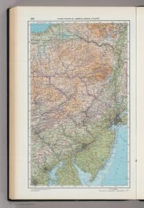
205. United States of America, Middle Atlantic. The World Atlas.
1 : 1250000 USSR (Union of Soviet Socialist Republics).
The provinces of New York, and New Jersey : with part of Pensilvania, and the governments of Trois Rivieres, and Montreal / drawn by Capt. Holland ; engraved by Thomas Jefferys, geographer to His Majesty.
from Parts
Index to the Plates in Christopher Colles' Survey of the Roads.
1 : 2027520 Ristow, W. editor
The tourist's pocket map of Pennsylvania: exhibiting its internal improvements, roads, distances &c. / by J. H. Young; D. Haines, sc.
from Whole J. H. Young; D. Haines,
The tourist's pocket map of Pennsylvania: exhibiting its internal improvements, roads, distances &c. / by J. H. Young; D. Haines, sc.
from Whole J. H. Young; D. Haines,
The tourist's pocket map of Pennsylvania: exhibiting its internal improvements, roads, distances &c. / by J.H. Young; D. Haines sc.
from Whole J. H. Young; D. Haines,
Pennsylvania / by David H. Burr; W. Harrison, sc.
from Whole David H. Burr; W. Harrison,
A New and accurate map of New Jersey : from the best authorities.
from Whole
Pennsylvania / drawn by S. Lewis.
from Whole Samuel Lewis,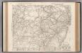
Auto Trails Map. Pennsylvania, New Jersey, Southern New York, Northern Delaware, Northern Maryland, Northern Virginia, North East W. Virginia.
1 : 822000 Rand McNally and Company
North America 1:1,000,000
1 : 1000000 Hudson (New York a New Jersey : řeka : oblast) United States Geological survey
Routes between New-York & Washington / drawn by I. Smith, geographer.
from Parts
New York.
1 : 570000 Rand McNally and Company
A map of New Jersey, from the best authorities.
from The American geography; or, A view of the present situation of the United States of America: containing astronomical geography; geographical definitions, discovery, and general description ... By Jedidiah Morse, A.M.
An Accurate map of New York in North America, from a late survey.
from John H. Levine Collection J. (John) Hinton: [London],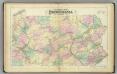
Penn. railway map.
1 : 792000 Gray, Frank Arnold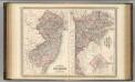
New Jersey, Delaware, and Maryland.
1 : 700000 Johnson, A.J.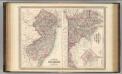
New Jersey, Delaware, and Maryland.
1 : 700000 Johnson, A.J.
A map of the roads leading to the town of Britania in the British settlement, Susquehanna County, Penna. / drawn by H.S. Tanner; T.V.K. & Co. sc.
from Cities and towns, A - Z Henry S. Tanner,
A Map Of The State Of Pennsylvania.
1 : 310000 Howell, Reading
Map of the State of New Jersey
from Atlas of Hunterdon County, New Jersey : from recent and actual surveys and records / under the superintendence of F.W. Beers.
New Jersey / engraved by J.H. Young.
from Whole
Map of the canals and rail roads for transporting anthracite coal from the several coal fields to the city of New York
1 : 322000 Lorenz, William Hunckel & Son
The Province of New Jersey, divided into East and West, commonly called the Jerseys / engraved & published by Wm. Faden.
from Charts and maps
Map of The State of New Jersey
from Atlas of Monmouth co., New Jersey. From recent and actual surveys and records, under the superintendence of F.W. Beers.
Seat of war in the environs of Philadelphia / by Thos. Kitchin Senr., hydrographer to His Majesty.
from Revolutionary War, 1775-1783
Map of the country embracing the several routes examined with a view to a national road from Washington to Lake Ontario
1 : 332000 Harrison, F. Harrison, F.
Pennsylvania / W. Barker sculp.; Carey's American pocket atlas; containing nineteen maps... with a brief description of each state.
from Carey's American pocket atlas; containing nineteen maps... with a brief description of each state. Carey, Mathew; Sweitzer, Henry,
The Province of New Jersey, divided into East and West, commonly called the Jerseys / engraved & published by Wm. Faden, Charing Cross, December 1st, 1777 ; Croisey, sculpt.
from Whole