Maps of St Edmundsbury
Suffolk LXI.3 (includes: Great Bradley; Little Bradley; Little Thurlow) - 25 Inch Map
1 : 2500 Topographic maps Ordnance Survey Ordnance Survey
Suffolk LXI.3 (includes: Great Bradley; Little Bradley; Little Thurlow) - 25 Inch Map
1 : 2500 Topographic maps Ordnance Survey Ordnance Survey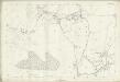
Suffolk LXI.3 (includes: Great Bradley; Little Bradley; Little Thurlow) - 25 Inch Map
1 : 2500 Topographic maps Ordnance Survey Ordnance Survey
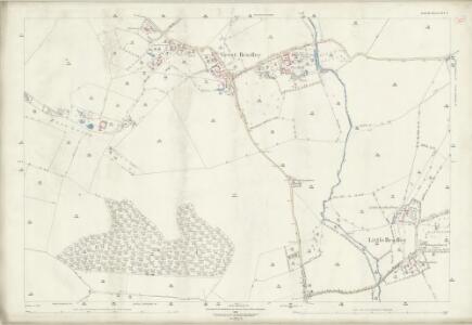
Suffolk LXI.NE - OS Six-Inch Map
1 : 10560 Topographic maps Ordnance Survey Ordnance Survey
Suffolk LXI.NE - OS Six-Inch Map
1 : 10560 Topographic maps Ordnance Survey Ordnance Survey
Suffolk LXI.NE - OS Six-Inch Map
1 : 10560 Topographic maps Ordnance Survey Ordnance Survey
Suffolk LXI.NE - OS Six-Inch Map
1 : 10560 Topographic maps Ordnance Survey Ordnance Survey
Suffolk LXI.NE - OS Six-Inch Map
1 : 10560 Topographic maps Ordnance Survey Ordnance Survey
TL65 - OS 1:25,000 Provisional Series Map
1 : 25000 Topographic maps Ordnance Survey Ordnance Survey
Newmarket 3
1 : 31680 .Even before horse racing became one of Newmarket's attractions under James I, Chevely Park at the top of this plan was famous for horse breeding., When this map was drawn, the Duke of Rutland had just taken possession of the park where he continued the equestrain tradition begun by kings Athelstan and Canute., Other notable landmarks include: Denham Hall towards the top right, with the layout of the gardens shown in detail; the site of,the eponymous,temple near Temple Wood towards the bottom; and the ruins of a chapel at Brinkley, to the left of centre. Metcalf, Edward B.
Saffron Walden (Hills) - OS One-Inch Revised New Series
1 : 63360 Topographic maps Ordnance Survey Ordnance Survey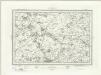
Saffron Walden (Outline) - OS One-Inch Revised New Series
1 : 63360 Topographic maps Ordnance Survey Ordnance Survey
Cambridge and Ely - OS One-Inch Map
1 : 63360 Topographic maps Ordnance Survey Ordnance Survey
Saffron Walden - OS One-Inch Map
1 : 63360 Topographic maps Ordnance Survey Ordnance Survey
Colchester - OS One-Inch Map
1 : 63360 Topographic maps Ordnance Survey Ordnance Survey
Cary's Improved Map of England and Wales
Cary, George, & Cary, John London : G. & J. Cary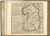

Cantabrigiensis comitatvs
1 Karte : Kupferdruck ; 41 x 51 cm Blaeu Joan Blaeu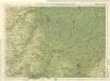
Cambridge, Huntingdon, Sheet 19 - Bartholomew's "Half Inch to the Mile Maps" of England & Wales
1 : 126720 Topographic maps Bartholomew, John George John Bartholomew & Co
Comitatis Cantabrigiensis; vernacule Cambridge Shire
1 Karte : Kupferdruck ; 40 x 50 cm Valck; Schenk venditant Gerardus Valk et Petrus Schenk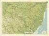
Suffolk, Sheet 20 - Bartholomew's "Half Inch to the Mile Maps" of England & Wales
1 : 126720 Topographic maps Bartholomew, John George John Bartholomew & Co
Bedford, Hertford, Sheet 25 - Bartholomew's "Half Inch to the Mile Maps" of England & Wales
1 : 126720 Topographic maps Bartholomew, John George John Bartholomew & Co
Cambridgeshire
1 : 390000 Hall, Sidney Chapmann & Hall
Regiones Inundatae In finibus Comitatus Norfolciae, Suffolciae, Cantabrigiae, Huntingtoniae[,] Northamtoniae, et Lincolniae [Karte], in: Theatrum orbis terrarum, sive, Atlas novus, Bd. 4, S. 301.
1 Karte aus Atlas Blaeu, Joan Blaeu, Willem Janszoon
Regiones Inundatae In finibus Comitatus Norfolciae, Suffolciae, Cantabrigiae, Huntingtoniae Northamtoniae, et Lincolniae [Karte], in: Le théâtre du monde, ou, Nouvel atlas contenant les chartes et descriptions de tous les païs de la terre, Bd. 4, S. 265.
1 Karte aus Atlas Blaeu, Willem Janszoon und Blaeu, Joan Blaeu, Willem Janszoon
CANTABRIGIENSIS | COMITATVS; | CAMBRIDGE SHIRE.
[Amsterdam : Joan Blaeu]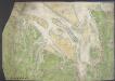
Chart of the mouth of the River Thames, c1540
This map, showing parts of Kent and Sussex, comes from a 16th-century portfolio of coastal charts and drawings It incorporates miniature copies of town plans that are now lost including what are probably the earliest plans of Canterbury, Rochester and Sandwich The mapmaker was Sir Richard Cavendish With its emphasis on sandbanks and beaches, the map was evidently intended for navigation and defence purposes The decorative quality of the map suggests it was meant for the eyes of the king, Henry VIII North is to the left of the map and East to the top, making the map appear on its side to modern eyes Cavendish, Sir Richard
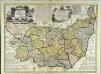
Suffolcia vernacula Suffolke
1 Karte : Kupferdruck ; 36 x 47 cm Valck; Schenk penes Gerardum Valk et Petrum Schenk
Svffolcia, vernacule Svffolke
1 Karte : Kupferdruck ; 37 x 48 cm Blaeu Joan Blaeu