Maps of Cambridgeshire

Cary's Improved Map of England and Wales
Cary, George, & Cary, John London : G. & J. Cary
Cantabrigiensis comitatvs
1 Karte : Kupferdruck ; 41 x 51 cm Blaeu Joan Blaeu
Cambridgeshire
1 : 390000 Hall, Sidney Chapmann & Hall
Comitatis Cantabrigiensis; vernacule Cambridge Shire
1 Karte : Kupferdruck ; 40 x 50 cm Valck; Schenk venditant Gerardus Valk et Petrus Schenk
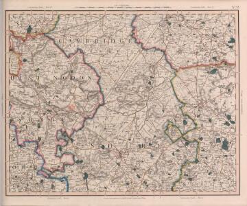
Cambridge, Huntingdon, Sheet 19 - Bartholomew's "Half Inch to the Mile Maps" of England & Wales
1 : 126720 Topographic maps Bartholomew, John George John Bartholomew & Co

Cambridge and Ely - OS One-Inch Map
1 : 63360 Topographic maps Ordnance Survey Ordnance Survey
Huntingdonensis Comitatus; Huntington Shire. [Karte], in: Le théâtre du monde, ou, Nouvel atlas contenant les chartes et descriptions de tous les païs de la terre, Bd. 4, S. 277.
1 Karte aus Atlas Blaeu, Willem Janszoon und Blaeu, Joan Blaeu, Willem Janszoon
Huntingdonensis Comitatus Huntingtonshire. [Karte], in: Novus atlas absolutissimus, Bd. 7, S. 301.
1 Karte aus Atlas Janssonius Offizin
Huntingdonensis Comitatus; Huntington Shire. [Karte], in: Theatrum orbis terrarum, sive, Atlas novus, Bd. 4, S. 315.
1 Karte aus Atlas Blaeu, Joan Blaeu, Willem Janszoon
Huntingdonensis Comitatus; Huntington Shire. [Karte], in: Theatrum orbis terrarum, sive, Atlas novus, Bd. 4, S. 315.
1 Karte aus Atlas Blaeu, Joan Blaeu, Willem Janszoon
HVNTINGDO- | NENSIS COMITATVS; | HUNTINGTON SHIRE.
[Amsterdam : Joan Blaeu]
Huntingdonensis Comitatus = Huntington Shire
1 : 130000 [Amstelodami] : [apud Joannem Janssonium]

An accurate map of the county of Huntingdon
1 Karte : Kupferdruck ; 69 x 51 cm Bowen; Hinton sold by I. Hinton at the Kings Arms in St. Pauls Church Yard
Littleport
1 : 31680 This drawing covers part of the Cambridgeshire fenland, an area characterised by straight, water-filled dykes dividing arable land. The New Bedford River is shown running down the middle of the sheet, almost parallel to the original Old Bedford River, taking the waters of the Great Ouse to Denver Sluice, at top right of the plan. In the 17th century, the Dutch engineer, Cornelius Vermuyden was appointed by James I to direct the drainage of the wetlands. As a result of Vermuyden's work, the fens took on a very different appearance, changing from an area of flooded marshes to one of extensively farmed agricultural land. Yeakell, Thomas Jr.Draughtsman
Hvntingdonensis comitatvs
1 Karte : Kupferdruck ; 38 x 48 cm Blaeu Joan Blaeu
Huntingdon and Peterborough - OS One-Inch Map
1 : 63360 Topographic maps Ordnance Survey Ordnance Survey
Feltwell St. Nicholas
1 : 31680 The pecked red line following the course of the Little Ouse marks the county boundary of Norfolk and Cambridgeshire. Drawn on the left of the sheet, along the Ouse Valley, is a patchwork of arable land divided by straight water-filled dykes, typical features of the fens landscape. This elaborate system of drains and river diversions was designed in the 17th century by a Dutch engineer called Vermuyden. It made possible the conversion of pasture to arable land in this region. Yeakell, Thomas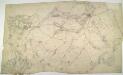
Horncastle
1 : 31680 The market town of Horncastle is shown between the Lincolnshire Wolds and the River Bain in the middle of this sheet. The river was navigable until the latter part of the 19th century, and was used to transport goods in and out of the town using flat-bottomed barges. Metcalfe, Edward B. Metcalfe, Edward B.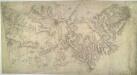
Cambridge 23
1 : 31680 Two types of landscapes characterise this part of Cambridgeshire. South of the City of Cambridge itself, a broad band of low, rolling chalk hills is intersected by river valleys. By contrast, the landscape at top right is fenland where arable expanses are divided by straight, water-filled dykes. Hyett, William
Ely (Hills) - OS One-Inch Revised New Series
1 : 63360 Topographic maps Ordnance Survey Ordnance Survey
Ely (Outline) - OS One-Inch Revised New Series
1 : 63360 Topographic maps Ordnance Survey Ordnance Survey
Cambridge (Hills) - OS One-Inch Revised New Series
1 : 63360 Topographic maps Ordnance Survey Ordnance Survey
Cambridge (Outline) - OS One-Inch Revised New Series
1 : 63360 Topographic maps Ordnance Survey Ordnance Survey
Ramsey (Hills) - OS One-Inch Revised New Series
1 : 63360 Topographic maps Ordnance Survey Ordnance Survey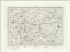
Ramsey (Outline) - OS One-Inch Revised New Series
1 : 63360 Topographic maps Ordnance Survey Ordnance Survey
Huntingdon (Hills) - OS One-Inch Revised New Series
1 : 63360 Topographic maps Ordnance Survey Ordnance Survey
Huntingdon (Outline) - OS One-Inch Revised New Series
1 : 63360 Topographic maps Ordnance Survey Ordnance Survey