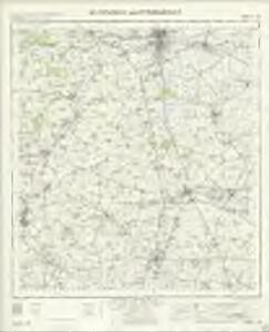
Maps of Huntingdonshire

Huntingdon and Peterborough - OS One-Inch Map
1 : 63360 Topographic maps Ordnance Survey Ordnance Survey
Huntingdonensis Comitatus Huntingtonshire. [Karte], in: Novus atlas absolutissimus, Bd. 7, S. 301.
1 Karte aus Atlas Janssonius Offizin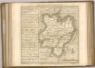

Huntingdonensis Comitatus; Huntington Shire. [Karte], in: Le théâtre du monde, ou, Nouvel atlas contenant les chartes et descriptions de tous les païs de la terre, Bd. 4, S. 277.
1 Karte aus Atlas Blaeu, Willem Janszoon und Blaeu, Joan Blaeu, Willem Janszoon
Huntingdonensis Comitatus; Huntington Shire. [Karte], in: Theatrum orbis terrarum, sive, Atlas novus, Bd. 4, S. 315.
1 Karte aus Atlas Blaeu, Joan Blaeu, Willem Janszoon
Huntingdonensis Comitatus; Huntington Shire. [Karte], in: Theatrum orbis terrarum, sive, Atlas novus, Bd. 4, S. 315.
1 Karte aus Atlas Blaeu, Joan Blaeu, Willem Janszoon
Huntingdonensis Comitatus = Huntington Shire
1 : 130000 [Amstelodami] : [apud Joannem Janssonium]
An accurate map of the county of Huntingdon
1 Karte : Kupferdruck ; 69 x 51 cm Bowen; Hinton sold by I. Hinton at the Kings Arms in St. Pauls Church Yard
HVNTINGDO- | NENSIS COMITATVS; | HUNTINGTON SHIRE.
[Amsterdam : Joan Blaeu]
Hvntingdonensis comitatvs
1 Karte : Kupferdruck ; 38 x 48 cm Blaeu Joan Blaeu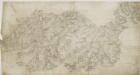
Wellingborough
1 : 31680 This drawing covers part of the valley of the River Nene as it meanders through farmland and the cottage industries of Wellingborough and Irthlingborough. Mills are depicted throughout the area, especially along the course of the Nene. With coal absent from the area, natural resources, predominantly wind and water, were used for industrial processing. Hyett, William
Huntingdon
1 : 31680 .This plan is dominated by fenland crossed by,drains, which are,indicated by single blue lines., The drainage system was installed in the 17th century,by Dutch engineer, Cornelius Vermuyden., The first years of the scheme were dogged,by riots and civil disobedience, much of the population viewing the scheme,as an encroachment upon the commonland,where they,grazed cattle. .The Crown and Woolpack, at the top left, is one of many inns along the toll road to Peterborough, which,forms the western boundary of this map., Outside the county town of Huntingdon is Hitchinbrooke House, dating back to AD600. Hyett, William
Oundle
1 : 31680 This drawing describes the boundary of Northamptonshire with Huntingdonshire, the border being indicated by a red dotted line near the right margin of the sheet. The River Nene is highlighted in blue at the upper left. North of the river valley, Rockingham Forest is represented by stippled treetops. The landscape between the Nene and Welland Valleys comprises farmland, open pasture, villages and pockets of woodland. Boyce
Huntingdon (Hills) - OS One-Inch Revised New Series
1 : 63360 Topographic maps Ordnance Survey Ordnance Survey
Huntingdon (Outline) - OS One-Inch Revised New Series
1 : 63360 Topographic maps Ordnance Survey Ordnance Survey
Ramsey (Hills) - OS One-Inch Revised New Series
1 : 63360 Topographic maps Ordnance Survey Ordnance Survey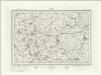
Ramsey (Outline) - OS One-Inch Revised New Series
1 : 63360 Topographic maps Ordnance Survey Ordnance Survey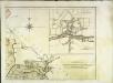
The county of Bedford, 2
1 Blatt : 53 x 72 cm s.n.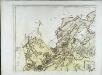
The county of Bedford, 1
1 Blatt : 53 x 72 cm s.n.
Caxton
1 : 31680 .Caxton was a parish along the Ermine Street, the Roman road from Chichester in West Sussex to York via Lincoln. The road forms the western boundary of the plan and is highlighted in buff. To the right of this boundary is the market and parish town of St. Neots, situated on the east bank of the navigable River Ouse. Here, a stone bridge, built in 1588 from the ruins of an old abbey, connects Huntingdonshire with Bedfordshire. Along the River Ouse, about a mile north of St Neots and partly in the parish of Little Paxton, are the premises of the St. Neots Paper Mill Company. Hyett, William
Kettering (Hills) - OS One-Inch Revised New Series
1 : 63360 Topographic maps Ordnance Survey Ordnance Survey
Kettering (Outline) - OS One-Inch Revised New Series
1 : 63360 Topographic maps Ordnance Survey Ordnance Survey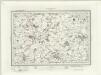
Wellingborough (Outline) - OS One-Inch Revised New Series
1 : 63360 Topographic maps Ordnance Survey Ordnance Survey
Wellingborough (Hills) - OS One-Inch Revised New Series
1 : 63360 Topographic maps Ordnance Survey Ordnance Survey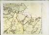
The county of Bedford, 4
1 Blatt : 53 x 72 cm s.n.
Stamford
1 : 31680 .This plan details a section of the Welland and Nene Valleys running through Cambridgeshire and Lincolnshire., It depicts the system of man-made drains, ditches and sluices,for draining the lowland area between Peterborough and Ely, offering a navigable route to the fenland rivers., Milton Park at the bottom right is a good example of 18th-century formal parkland, with grass, trees and lakes well detailed. Boyce
Stamford
This plan details a section of the Welland and Nene Valleys running through Cambridgeshire and Lincolnshire. It depicts the system of man-made drains, ditches and sluices for draining the lowland area between Peterborough and Ely, offering a navigable route to the fenland rivers. Milton Park at the bottom right is a good example of 18th-century formal parkland, with grass, trees and lakes well detailed. Boyce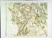
The county of Bedford, 3
1 Blatt : 53 x 72 cm s.n.
TL29 - OS 1:25,000 Provisional Series Map
1 : 25000 Topographic maps Ordnance Survey Ordnance Survey