Maps of Suffolk
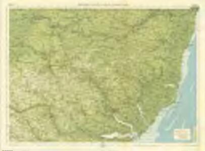
Suffolk, Sheet 20 - Bartholomew's "Half Inch to the Mile Maps" of England & Wales
1 : 126720 Topographic maps Bartholomew, John George John Bartholomew & Co
Suffolcia vernacula Suffolke
1 Karte : Kupferdruck ; 36 x 47 cm Valck; Schenk penes Gerardum Valk et Petrum Schenk
Svffolcia, vernacule Svffolke
1 Karte : Kupferdruck ; 37 x 48 cm Blaeu Joan Blaeu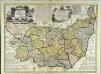
An accurate map of the county of Suffolk
1 Karte : Kupferdruck ; 50 x 69 cm Bowen; Hinton sold by I. Hinton at the Kings Arms in St. Pauls Church Yard
SVFFOLCIA. | Vernacule | SVFFOLKE.
[Amsterdam : Joan Blaeu]
Suffolcia vernacule Suffolke
1 : 240000 Joannes Janssonius excudit. [Amstelodami] : [apud Joannem Janssonium]
SUFFOLCIAE Comitatus Sheet 16
This map of Suffolk is from the 1583 edition of the Saxton atlas of England and Wales.This atlas was first published as a whole in 1579. It consists of 35 coloured maps depicting the counties of England and Wales. The atlas is of great significance to British cartography as it set a standard of cartographic representation in Britain and the maps remained the basis for English county mapping, with few exceptions, until after 1750. During the reign of Elizabeth I map use became more common, with many government matters referring to increasingly accurate maps with consistent scales and symbols, made possible by advances in surveying techniques. Illustrating the increasing used of maps in government matters, Lord Burghley, Elizabeth I’s Secretary of State, who had been determined to have England and Wales mapped in detail from the 1550s, selected the cartographer Christopher Saxton to produce a detailed and consistent survey of the country. The financier of the project was Thomas Seckford Master of Requests at the Court of Elizabeth I, whose arms appear, along with the royal crest, on each map. Saxton, Christopher Ryther, Augustine
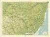
Sheets 35-36. (Cary's England, Wales, and Scotland).
1 : 360000 Cary, John, ca. 1754-1835
Lowestoft - OS One-Inch Map
1 : 63360 Topographic maps Ordnance Survey Ordnance Survey
Bury St Edmunds - OS One-Inch Map
1 : 63360 Topographic maps Ordnance Survey Ordnance Survey
Colchester - OS One-Inch Map
1 : 63360 Topographic maps Ordnance Survey Ordnance Survey
Ipswitch - OS One-Inch Map
1 : 63360 Topographic maps Ordnance Survey Ordnance Survey
Bury St Edmunds
The landscape here still reflected its medieval character in the early nineteeth century, as is seen through the dominance of named common fields, heaths and warrens. Eldon Field, Downham Warren, and Cutford Heath are just a few of the large labelled tracts of land appearing on this map. Stanley, William.
Orford(002OSD000000026U00278000)
1 : 31680 This is an original protraction of the Suffolk coastline, running inland,from Orford Ness,,on the right,,to Hasketon and Wickham., The various traverses (single lines surveyed from different points),are distinguished by colour: red, blue, yellow, light brown and dark brown. ,These skeleton protraction lines,form the first plottings from the field book of the area., At the bottom right, the plan is annotated in blue with the date of the traverse and the,corresponding page numbers in the field book. Metcalf, Edward B
Orford(002OSD000000026U00277000)
1 : 31680 This partly finished plan of the Suffolk coastline shows only roads and settlements to the left, but land use and relief detail have been added to the right. Original protraction lines remain in pencil: these represent the first plottings from the field book of the area. The handwritten note pasted at the bottom of the plan may have been trimmed from the margin. Metcalf, Edward B
Lowestoft (Hills) - OS One-Inch Revised New Series
1 : 63360 Topographic maps Ordnance Survey Ordnance Survey
Lowestoft (Outline) - OS One-Inch Revised New Series
1 : 63360 Topographic maps Ordnance Survey Ordnance Survey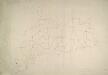
Eye
1 : 31680 This unfinished drawing of the Suffolk lowlands shows only the network of roads around Eye. A few of the roads and settlements have been inked in. Stanley, William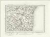
Saxmundham (Outline) - OS One-Inch Revised New Series
1 : 63360 Topographic maps Ordnance Survey Ordnance Survey
Saxmundham (Hills) - OS One-Inch Revised New Series
1 : 63360 Topographic maps Ordnance Survey Ordnance Survey
Woodbridge (Hills) - OS One-Inch Revised New Series
1 : 63360 Topographic maps Ordnance Survey Ordnance Survey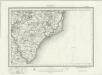
Woodbridge (Outline) - OS One-Inch Revised New Series
1 : 63360 Topographic maps Ordnance Survey Ordnance Survey
Diss (Hills) - OS One-Inch Revised New Series
1 : 63360 Topographic maps Ordnance Survey Ordnance Survey
Diss (Outline) - OS One-Inch Revised New Series
1 : 63360 Topographic maps Ordnance Survey Ordnance Survey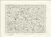
Eye (Outline) - OS One-Inch Revised New Series
1 : 63360 Topographic maps Ordnance Survey Ordnance Survey
Eye (Hills) - OS One-Inch Revised New Series
1 : 63360 Topographic maps Ordnance Survey Ordnance Survey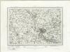
Ipswich (Outline) - OS One-Inch Revised New Series
1 : 63360 Topographic maps Ordnance Survey Ordnance Survey
Ipswich (Hills) - OS One-Inch Revised New Series
1 : 63360 Topographic maps Ordnance Survey Ordnance Survey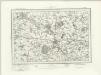
Bury St Edmunds (Outline) - OS One-Inch Revised New Series
1 : 63360 Topographic maps Ordnance Survey Ordnance Survey