Maps of Cambridgeshire

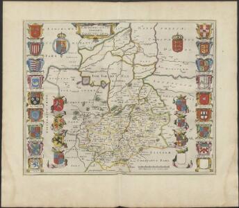
CANTABRIGIENSIS | COMITATVS; | CAMBRIDGE SHIRE.
[Amsterdam : Joan Blaeu]
Cantabrigiensis Comitatus; Cambridge Shire. [Karte], in: Theatrum orbis terrarum, sive, Atlas novus, Bd. 4, S. 306.
1 Karte aus Atlas Blaeu, Joan Blaeu, Willem Janszoon
Cantabrigiensis Comitatus; Cambridge Shire. [Karte], in: Le théâtre du monde, ou, Nouvel atlas contenant les chartes et descriptions de tous les païs de la terre, Bd. 4, S. 270.
1 Karte aus Atlas Blaeu, Willem Janszoon und Blaeu, Joan Blaeu, Willem Janszoon
Cantabrigiensis Comitatus; Cambridge Shire. [Karte], in: Theatrum orbis terrarum, sive, Atlas novus, Bd. 4, S. 306.
1 Karte aus Atlas Blaeu, Joan Blaeu, Willem Janszoon
Comitatis Cantabrigiensis; vernacule Cambridgeshire. [Karte], in: Novus atlas absolutissimus, Bd. 7, S. 294.
1 Karte aus Atlas Janssonius Offizin
Comitatis Cantabrigiensis, vernacule Cambridge Shire
1 : 210000 Amstelodami : apud Joannem Janssonium
Cambridgeshire
1 : 390000 Hall, Sidney Chapmann & Hall
Cantabrigiensis comitatvs
1 Karte : Kupferdruck ; 41 x 51 cm Blaeu Joan Blaeu
The Fens
This is a map of the fenlands dating from around 1603. It is thought to be the model for Hondius's "A generall plotte of the Fennes" published in Amsterdam in 1632 and is signed Ro. Cotton. The map shows the area in some detail, generalised representations of churches represent small settlements. Larger towns such as Cambridge and Bury St Edmunds' are shown in more detail with individualised red roofed buildings. The sands or the washes are indicated by dotted lines and a beacon is marked on the sands. A notable feature of the drawing is the proliferation of windmills as the wind from the sea can move inland unhindered by hills.

Comitatis Cantabrigiensis; vernacule Cambridge Shire
1 Karte : Kupferdruck ; 40 x 50 cm Valck; Schenk venditant Gerardus Valk et Petrus Schenk
Regiones Inundatae In finibus Comitatus Norfolciae, Suffolciae, Cantabrigiae, Huntingtoniae Northamtoniae, et Lincolniae [Karte], in: Le théâtre du monde, ou, Nouvel atlas contenant les chartes et descriptions de tous les païs de la terre, Bd. 4, S. 265.
1 Karte aus Atlas Blaeu, Willem Janszoon und Blaeu, Joan Blaeu, Willem Janszoon
A general plott and description of the Fennes and surounded grounds in the sixe counties of Norfolke, Suffolke, Cambridge
1 Karte : Kupferdruck ; 44 x 55 cm Valck; Schenk sumptibus G. Valk et P. Schenk
Regiones invndatæ in finibus comitatus Norfolciæ, Svffolciæ, Cantabrigiæ, Hvntingtoniæ Northamtoniæ, et Lincolniæ
1 Karte : Kupferdruck ; 43 x 54 cm Blaeu Joan Blaeu
A general plott and description of the Fennes and surounded grounds in the sixe counties of Norfolke, Suffolke, Cambridge
1 Karte : Kupferdruck ; 44 x 55 cm Mercator; Hondius sumptibus Henrici Hondii
Regiones Inundatae In finibus Comitatus Norfolciae, Suffolciae, Cantabrigiae, Huntingtoniae[,] Northamtoniae, et Lincolniae [Karte], in: Theatrum orbis terrarum, sive, Atlas novus, Bd. 4, S. 301.
1 Karte aus Atlas Blaeu, Joan Blaeu, Willem Janszoon
A general plott and description of the Fennes and surounded grounds in the sixe counties of Norfolke, Suffolke, Cambridge, with in the Isle of Ely, Huntington, Northampton and Lincolne etc.
1 : 180000 Amstelodami : sumptibus Joannis Janssonii
Regiones Inundatae In finibus Comitatus Norfolciae, Suffolciae, Cantabrigiae, Huntingtoniae[,] Northamtoniae, et Lincolniae [Karte], in: Theatrum orbis terrarum, sive, Atlas novus, Bd. 4, S. 301.
1 Karte aus Atlas Blaeu, Joan Blaeu, Willem Janszoon
A general Plot and description of the Fennes and surounded grounds in the sixe Counties of Norfolke, Suffolke, Cambridge [...] [Karte], in: Novus atlas absolutissimus, Bd. 7, S. 306.
1 Karte aus Atlas Janssonius Offizin
REGIONES | INVNDATÆ | In finibus Comitatus | NORFOLCIÆ, SUFFOLCIÆ, | CANTABRIGIÆ, HVNTINGTONIÆ | NORTHAMTONIÆ, et | LINCOLNIÆ
[Amsterdam : Joan Blaeu]
Cambridge, Huntingdon, Sheet 19 - Bartholomew's "Half Inch to the Mile Maps" of England & Wales
1 : 126720 Topographic maps Bartholomew, John George John Bartholomew & Co
Cary's Improved Map of England and Wales
Cary, George, & Cary, John London : G. & J. Cary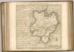

Cambridge and Ely - OS One-Inch Map
1 : 63360 Topographic maps Ordnance Survey Ordnance Survey
Huntingdonensis Comitatus Huntingtonshire. [Karte], in: Novus atlas absolutissimus, Bd. 7, S. 301.
1 Karte aus Atlas Janssonius Offizin
HVNTINGDO- | NENSIS COMITATVS; | HUNTINGTON SHIRE.
[Amsterdam : Joan Blaeu]
Huntingdonensis Comitatus; Huntington Shire. [Karte], in: Le théâtre du monde, ou, Nouvel atlas contenant les chartes et descriptions de tous les païs de la terre, Bd. 4, S. 277.
1 Karte aus Atlas Blaeu, Willem Janszoon und Blaeu, Joan Blaeu, Willem Janszoon
Huntingdonensis Comitatus; Huntington Shire. [Karte], in: Theatrum orbis terrarum, sive, Atlas novus, Bd. 4, S. 315.
1 Karte aus Atlas Blaeu, Joan Blaeu, Willem Janszoon
Huntingdonensis Comitatus; Huntington Shire. [Karte], in: Theatrum orbis terrarum, sive, Atlas novus, Bd. 4, S. 315.
1 Karte aus Atlas Blaeu, Joan Blaeu, Willem Janszoon