Maps of Gloucestershire
Wiltshire X.5 (includes: Braydon; Cricklade; Purton) - 25 Inch Map
1 : 2500 Topographic maps Ordnance Survey Ordnance Survey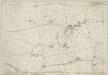
Wiltshire X.5 (includes: Braydon; Cricklade; Purton) - 25 Inch Map
1 : 2500 Topographic maps Ordnance Survey Ordnance Survey
Wiltshire X.5 (includes: Braydon; Cricklade; Purton) - 25 Inch Map
1 : 2500 Topographic maps Ordnance Survey Ordnance Survey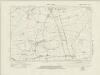
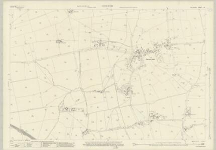
Wiltshire X.NW - OS Six-Inch Map
1 : 10560 Topographic maps Ordnance Survey Ordnance Survey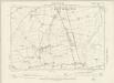
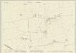
Wiltshire X.NW - OS Six-Inch Map
1 : 10560 Topographic maps Ordnance Survey Ordnance Survey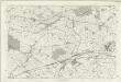
Wiltshire X - OS Six-Inch Map
1 : 10560 Topographic maps Ordnance Survey Ordnance Survey
Cricklade
1 : 31680 The drawing is framed by a formal border, confirming its status as complete. Black crosses, labelled Brinkworth and Purton, indicate points from which the surveyor took angular measurements. Bury Hill Camp and Ringsbury Camp, both iron-age hillforts, are indicated by soft interlining and loosely rendered concentric rings. Crocker, Edmund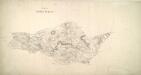
Lydiard
1 : 21120 This drawing covers part of Gloucester, the county boundary being indicated by a pecked red line. The drawing is delicately rendered with light pencil interlinings ('hachures') representing relief. Major communication routes are tinted yellow with their length noted at intervals of one mile. This indicates the serious military focus of the survey. In the margins of the drawing, several dots within circles annotated by place names mark the trigonometric stations from which the surveyor plotted the area's topography. A note in the bottom margin records the date of execution and the name draughtsman, recording him as a Royal Military Surveyor. Metcalf, Edward B.
Swindon (Hills) - OS One-Inch Revised New Series
1 : 63360 Topographic maps Ordnance Survey Ordnance Survey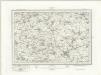
Swindon (Outline) - OS One-Inch Revised New Series
1 : 63360 Topographic maps Ordnance Survey Ordnance Survey
Swindon
1 : 31680 The author of this drawing, William Stanley, was listed as a 'first class' Military draughtsman and surveyor at the Tower of London Drawing Room. His elaborate hill shading technique for describing relief and the attention he pays to communications routes reinforce the military emphasis of these maps. Archaeological details are documented even though this did not become obligatory until 1816. The iron-age hillfort at Barbury Castle is described, along with numerous barrows and earthworks. Stanley, William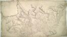
Cirencester(002OSD000000020U00118000)
1 : 31680 This drawing covers the counties of Gloucestershire, Oxfordshire and Wiltshire, with their boundaries indicated by pecked lines. The Roman road to Bath is tinted yellow to highlight it as a major communication route. A dotted line leading from Sapperton indicates the Sapperton Tunnel, which was opened in 1789. Linked to the Thames and Severn Canal, it was, at that time, the longest tunnel in England. The Sapperton Tunnel enabled boats carry coal cheaply to Cirencester from mines in the north and west. Several trigonometrical points are marked by dots within circles. These were points from which the surveyor took angular measurements to determine the relative locations of prominent features of the landscape. Metcalf, Edward B.
Swindon - OS One-Inch Map
1 : 63360 Topographic maps Ordnance Survey Ordnance Survey
Ordnance Survey of England. Sheet 256, North London
1 : 63360 Ordnance survey. GB Southampton : Ordnance Survey Office
An improved map of Wilt Shire
1 Karte : Kupferdruck ; 52 x 68 cm Bowen; Tinney sold by I. Tinney at the Golden Lion in Fleet street
Wiltonia sive comitatvs Wiltoniensis; anglis Wil Shire
1 Karte : Kupferdruck ; 40 x 48 cm Blaeu Joan Blaeu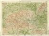
Berkshire, Sheet 29 - Bartholomew's "Half Inch to the Mile Maps" of England & Wales
1 : 126720 Topographic maps Bartholomew, John George John Bartholomew & Co
Wiltonia sive Comitatus Wiltoniensis anglis Wil Shire
1 : 210000 Amstelodami : apud Joannem Janssonium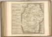

WILTONIAE Comitatus
This is a map of Wiltshire by Christopher Saxton which dates from 1576. It forms part of an atlas that belonged to William Cecil Lord Burghley, Elizabeth I’s Secretary of State. Burghley used this atlas to illustrate domestic matters. This map is actually a proof copy of one which forms part of Christopher Saxton’s Atlas of England and Wales. This atlas was first published as a whole in 1579. It consists of 35 coloured maps depicting the counties of England and Wales. The atlas is of great significance to British cartography as it set a standard of cartographic representation in Britain and the maps remained the basis for English county mapping, with few exceptions, until after 1750. During the reign of Elizabeth I, map use became more common, with many government matters referring to increasingly accurate maps with consistent scales and symbols, made possible by advances in surveying techniques. Illustrating the increasing use of maps in government matters, Lord Burghley, who had been determined to have England and Wales mapped in detail from the 1550s, selected the cartographer Christopher Saxton to produce a detailed and consistent survey of the country. The financier of the project was Thomas Seckford Master of Requests at the Court of Elizabeth I, whose arms appear, along with the royal crest on each map .Lord Burghley has added several place names to the map. This map was engraved by Remigius Hogenbergius, one of a team of seven English and Flemish engravers employed to produce the copper plates for the atlas. Saxton, Christopher Hogenbergius, Remigius
WILTONIA | sive | COMITATVS WILTONI- | ENSIS; Anglis | WIL SHIRE.
[Amsterdam : Joan Blaeu]
Glocestria dvcatvs; vulgo Glocester Shire
1 Karte : Kupferdruck ; 40 x 48 cm Blaeu Joan Blaeu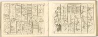

WILTONIAE
This map of Wiltshire is from the 1583 edition of the Saxton atlas of England and Wales. TThis atlas was first published as a whole in 1579. It consists of 35 coloured maps depicting the counties of England and Wales. The atlas is of great significance to British cartography as it set a standard of cartographic representation in Britain and the maps remained the basis for English county mapping, with few exceptions, until after 1750. During the reign of Elizabeth I map use became more common, with many government matters referring to increasingly accurate maps with consistent scales and symbols, made possible by advances in surveying techniques. Illustrating the increasing used of maps in government matters, Lord Burghley, Elizabeth I’s Secretary of State, who had been determined to have England and Wales mapped in detail from the 1550s, selected the cartographer Christopher Saxton to produce a detailed and consistent survey of the country. The financier of the project was Thomas Seckford Master of Requests at the Court of Elizabeth I, whose arms appear, along with the royal crest, on each map. Saxton’s name appears in the decorative scale bar as does the name of the engraver of this map, Remigius Hogenberg ,one of seven English and Flemish engravers employed to produced the copper plates for the atlas. Relief, in the form of uniform rounded representations of hills, is the main topographical feature presented in the maps. Rather than provide a scientific representation of relative relief these give a general impression of the lie of the land. Settlements and notable buildings are also recorded pictorially; a small building with a spire represents a village, while more important towns are indicated by groups of buildings. Here Stonehenge is marked by a pictorial representation and named The Stonadge’. Saxton, Christopher Ryther, Augustine
Glocestria dvcatvs, Monvmethensi comitatu
1 Karte : Kupferdruck ; 39 x 49 cm Valck; Schenk penes G. Valk et P. Schenk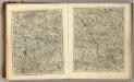
Sheets 23-24. (Cary's England, Wales, and Scotland).
1 : 360000 Cary, John, ca. 1754-1835
Oxonium Comitatus, Vulgo Oxford Shire. [Karte], in: Theatrum orbis terrarum, sive, Atlas novus, Bd. 4, S. 237.
1 Karte aus Atlas Blaeu, Joan Blaeu, Willem Janszoon
Oxonium Comitatus Vulgo Oxford Shire. [Karte], in: Novus atlas absolutissimus, Bd. 7, S. 230.
1 Karte aus Atlas Janssonius Offizin
Oxonium Comitatus, Vulgo Oxford Shire. [Karte], in: Le théâtre du monde, ou, Nouvel atlas contenant les chartes et descriptions de tous les païs de la terre, Bd. 4, S. 209.
1 Karte aus Atlas Blaeu, Willem Janszoon und Blaeu, Joan Blaeu, Willem Janszoon