Maps of South Bucks

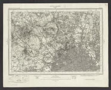
Ordnance Survey of England. Sheet 256, North London
1 : 63360 Ordnance survey. GB Southampton : Ordnance Survey Office
Lydiard
1 : 21120 This drawing covers part of Gloucester, the county boundary being indicated by a pecked red line. The drawing is delicately rendered with light pencil interlinings ('hachures') representing relief. Major communication routes are tinted yellow with their length noted at intervals of one mile. This indicates the serious military focus of the survey. In the margins of the drawing, several dots within circles annotated by place names mark the trigonometric stations from which the surveyor plotted the area's topography. A note in the bottom margin records the date of execution and the name draughtsman, recording him as a Royal Military Surveyor. Metcalf, Edward B.
North London (Hills) - OS One-Inch Revised New Series
1 : 63360 Topographic maps Ordnance Survey Ordnance Survey
North London (Outline) - OS One-Inch Revised New Series
1 : 63360 Topographic maps Ordnance Survey Ordnance Survey
Beaconsfield (Outline) - OS One-Inch Revised New Series
1 : 63360 Topographic maps Ordnance Survey Ordnance Survey
Beaconsfield (Hills) - OS One-Inch Revised New Series
1 : 63360 Topographic maps Ordnance Survey Ordnance Survey
Carte topographique de le comté de Middlesex, 1
1 Blatt : 53 x 69 cm John Rocque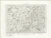
Henley on Thames (Outline) - OS One-Inch Revised New Series
1 : 63360 Topographic maps Ordnance Survey Ordnance Survey
Henley on Thames (Hills) - OS One-Inch Revised New Series
1 : 63360 Topographic maps Ordnance Survey Ordnance Survey
Abingdon (Hills) - OS One-Inch Revised New Series
1 : 63360 Topographic maps Ordnance Survey Ordnance Survey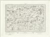
Abingdon (Outline) - OS One-Inch Revised New Series
1 : 63360 Topographic maps Ordnance Survey Ordnance Survey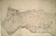
Wantage
1 : 31680 The bottom boundary of this map of White Horse Vale is formed by the Ridge Way, an ancient grass track. The Wiltshire and Berkshire Canal runs through the centre of the landmass. The elaborate hill-shading and the attention paid to communications routes conform to the military and cartographic standards employed by the Ordnance Survey. The manuscript is made up of three separate pieces of paper, joined together at a later date and attached to stiffer paper. Stanley, William
London passenger transport map
Ordnance Survey
Swindon (Hills) - OS One-Inch Revised New Series
1 : 63360 Topographic maps Ordnance Survey Ordnance Survey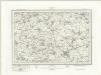
Swindon (Outline) - OS One-Inch Revised New Series
1 : 63360 Topographic maps Ordnance Survey Ordnance Survey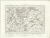
Malmesbury (Outline) - OS One-Inch Revised New Series
1 : 63360 Topographic maps Ordnance Survey Ordnance Survey
Malmesbury (Hills) - OS One-Inch Revised New Series
1 : 63360 Topographic maps Ordnance Survey Ordnance Survey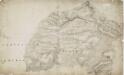
Malmesbury
1 : 31680 This drawing covers the counties of Gloucestershire and Wiltshire, with their boundary indicated by a pecked line. The Wiltshire and Berkshire Canal is shown. Individual locks are indicated by breaks in the blue watercolour line. The Roman road from Bath to Cirencester is marked, and "Ancient Entrenchments" are noted nearby, represented by tiny outline plans of their structure. Crocker, Edmund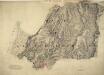
Chipping Sodbury
1 : 31680 The Avon barracks and battery are documented at the mouth of the River Severn, at the top of the map, protecting the Bristol Channel. Gravemounds ('Tumuli'), hill forts, ancient camps and antiquities are distinguished by the use of gothic lettering. The recording of archaeological details became obligatory in 1816. Quarries, kilns, mills, brickyards and pits dominate this industrial region of the West Midlands. According to a note in the Ordnance Survey Day Books, held in the National Archives, a one inch-to-the-mile reduction of this plan was delivered to Captain Gossett for engraving in the Drawing Office at the Tower of London in March 1830. Crocker, Edmund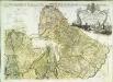
Carte topographique de le comté de Middlesex, 2
1 Blatt : 53 x 73 cm John Rocque
Plan of a Proposed TURNPIKE ROAD From St. JOHN'S CHAPEL, ST. MARYLEBONE into the Great North Road Near the 8 Mile Stone at Finchley
1 : 31680 Plan of the proposed turnpike road from Regent's Park to Finchley, today's Finchley Road. The plan features title at top right, scale bars at lower right and sections of the road in elevation at the foot of the plate, with the new road represented by a double dotted line coloured red. Down the left of the plate a table gives distances between stations along the road and shows the savings in milage generated by the new road. Phillips, Henry
Chepstow (Hills) - OS One-Inch Revised New Series
1 : 63360 Topographic maps Ordnance Survey Ordnance Survey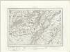
Chepstow (Outline) - OS One-Inch Revised New Series
1 : 63360 Topographic maps Ordnance Survey Ordnance Survey
A topographical map, of the county, of Berks, Blatt XI und XVII
2 Blätter : 99 x 52 cm John Rocque
A topographical map, of the county, of Berks, Blatt X und XVI
2 Blätter : 99 x 52 cm John Rocque
Uxbridge, Windsor
1 : 31680 This plan of the Chiltern Hills runs from Beaconsfield and Harefield at the top to Windsor Park, Egham and Staines at the bottom. A section of the Grand Junction Canal, running from Harefield down to West Drayton, is shown in aquamarine. The paper carries the watermark "E ,amp; P", standing for Edmeads and Pine. Boyce
A topographical map, of the county, of Berks, Blatt VII und XIII
2 Blätter : 99 x 52 cm John Rocque
A topographical map, of the county, of Berks, Blatt VIII und XIV
2 Blätter : 99 x 52 cm John Rocque
Cricklade
1 : 31680 The drawing is framed by a formal border, confirming its status as complete. Black crosses, labelled Brinkworth and Purton, indicate points from which the surveyor took angular measurements. Bury Hill Camp and Ringsbury Camp, both iron-age hillforts, are indicated by soft interlining and loosely rendered concentric rings. Crocker, Edmund