Maps of Hackney

TQ38 - OS 1:25,000 Provisional Series Map
1 : 25000 Topographic maps Ordnance Survey Ordnance Survey
Plan showing the sewers in Tower Hamlets, 1843
From 1807, the East End was supplied with water pumped from the River Lea at Bow by the East London Waterworks Company. This was not, however, the continuous flow of water we take for granted today. Dr John Simon wrote, in 1849, of the thousands who "wholly depend on their power of attending at some fixed hour of the day, pail in hand, beside the nearest standcock; where, with their neighbours, they wait their turn; sometimes not without a struggle, during the tedious dribbling of a single small pipe. Household rubbish was piled into heaps in the street and outdoor toilets drained into cesspits. The survey of sanitation in Bethnal Green made by Hector Gavin in 1848 paints a sorry picture. Knightly Court was typical of the streets he visited: "In it there are two privies in a beastly state, full, and the contents overflowing into the court. There is one dust reservoir. One stand-tap supplies the seven houses; two cases of severe typhus lately occurred here, one died." This map of 1843 shows the distribution of sewers through the East End. They carried only surface water, contaminated with decayed rubbish from the streets and excrement from overflowing cesspits, and discharged it directly into the Thames - from which water companies pumped their drinking water. James Beek
London NE.
1 : 15840 Stanford, Edward
Charles Booth's 'Descriptive Map of London Poverty'. Detail showing the City of London and the East End
The East End of London is the hell of poverty. Like one enormous black, motionless giant kraken, the poverty of London lies there in lurking silence and encircles with its mighty tentacles the life and wealth of the City. So wrote J H Mackay in 1891. It was acknowledged that the blame lay with overcrowded housing and with a surplus of labour, which kept wages low for those lucky enough to find work. Statistics for 1888 showed that the East End had 8,465 official paupers - people 'living rough'. According to Charles Booth's survey in 1889, over a third of its inhabitants lived on or below the margin of poverty. His 17-volume survey included this coloured-coded map indicating London's poverty and prosperity street by street. The key to the colours used is as follows: Gold: Upper-middle and Upper classes.Wealthy. Red: Well-to-do. Middle-class. Pink: Fairly comfortable. Good ordinary earning. Purple: Mixed. Some comfortable, others poor. Pale Blue: Poor. 18s. to 21s. a week for moderate family Dark blue: Very poor, casual. Chronic want. Black: Lowest class. Vicious, semi-criminal. Booth, Charles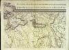
An exact survey of the city's of London Westminster , V
1 Blatt : 53 x 71 cm John Rocque
Insurance Plan of London North & North-East District Vol. E: Key Plan
1 : 21120 This "key plan" indicates coverage of the Goad 1899 series of fire insurance maps of London that were originally produced to aid insurance companies in assessing fire risks. The building footprints, their use (commercial, residential, educational, etc.), the number of floors and the height of the building, as well as construction materials (and thus risk of burning) and special fire hazards (chemicals, kilns, ovens) were documented in order to estimate premiums. Names of individual businesses, property lines, and addresses were also often recorded. Together these maps provide a rich historical shapshot of the commercial activity and urban landscape of towns and cities at the time. The British Library holds a comprehensive collection of fire insurance plans produced by the London-based firm Charles E. Goad Ltd. dating back to 1885. These plans were made for most important towns and cities of the British Isles at the scales of 1:480 (1 inch to 40 feet), as well as many foreign towns at 1:600 (1 inch to 50 feet). Chas E Goad Limited Chas E Goad Limited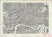
London Sheet K - OS Six-Inch Map
1 : 10560 Topographic maps Ordnance Survey Ordnance Survey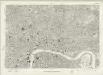
London Sheet K - OS Six-Inch Map
1 : 10560 Topographic maps Ordnance Survey Ordnance Survey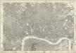
Middlesex XVII - OS Six-Inch Map
1 : 10560 Topographic maps Ordnance Survey Ordnance Survey
London
Grosser Hand-Atlas über alle Theile der Erde in 170 Karten Meyer, J. Verlag des Bibliographischen Instituts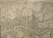
A PLAN of the CITIES of LONDON WESTMINSTER & the BOROUGH of SOUTHWARK Reduc'd to the Same Scale as those of PARIS ROME & DUBLIN
This map comprises two sheets with the title along the top in English and French, and a note comparing built-up areas of the four European capitals. City boundaries are outlined in colour. This is Robert Sayer's 1773 edition of the map first issued by Rocque in 1761. Rocque, John
A Survey of the Roads and Foot-paths in the Parish of ISLINGTON. From a plan in the Vestry Room, Drawn in the Year 1735
1 : 14400 This is a plan of footpaths and roads in the parish of Islington. It extends from Battle Bridge to Highgate and from ''Cruch End'' to Kings Land and the boundary to Shoreditch. An interesting feature on this map is Jack Straws House near Highbury. Jack Straw was a leader of one band of rebels who attacked the Treasurer's House at Highbury on June 14, 1381. The Peasants' Revolt over increasing taxation was largely due to the monarchy's prosectution of war against France. Toll gates are also marked in various places. Hawsworth, J.
PLAN OF ISLINGTON PARISH
1 : 9744 This detailed plan of the parish of Islington records each property and field boundary and even indicates the layout of the gardens and trees. A vignette in the lower right corner shows a view of Canonbury from 1821. The note at lower left reports the increase in building over the last seven years and the population growth. Dent, R.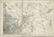
Essex LXXIII - OS Six-Inch Map
1 : 10560 Topographic maps Ordnance Survey Ordnance Survey
PLAN of the Parish of St. Mary. Islington
This is a plan of the parish of St Mary's, Islington, with three vignettes depicting the Scotch Church, the New Church and St Peter's Chapel down the right of the plate. Baker, B.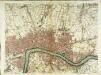
A plan of London
1 Karte : Kupferdruck ; 50 x 66 cm Rocque; Parr publish'd 29.th april according to act of parliament by John Rocque
Londini Angliæ regni metropolis delineatio accuratissima
1 Plan : Kupferdruck ; 34 x 58 cm, Bildgrösse 50 x 58 cm Aa chez Pierre vander Aa libraire imprimeur de l'université et de la ville
Insurance Plan of London North North West District Vol. D: Key Plan
1 : 10560 This "key plan" indicates coverage of the Goad 1892 series of fire insurance maps of London that were originally produced to aid insurance companies in assessing fire risks. The building footprints, their use (commercial, residential, educational, etc.), the number of floors and the height of the building, as well as construction materials (and thus risk of burning) and special fire hazards (chemicals, kilns, ovens) were documented in order to estimate premiums. Names of individual businesses, property lines, and addresses were also often recorded. Together these maps provide a rich historical shapshot of the commercial activity and urban landscape of towns and cities at the time. The British Library holds a comprehensive collection of fire insurance plans produced by the London-based firm Charles E. Goad Ltd. dating back to 1885. These plans were made for most important towns and cities of the British Isles at the scales of 1:480 (1 inch to 40 feet), as well as many foreign towns at 1:600 (1 inch to 50 feet). Chas E Goad Limited Chas E Goad Limited
Insurance Plan of London Vol. xi: Key Plan 1
1 : 3600 This "key plan" indicates coverage of the Goad 1891 series of fire insurance maps of London that were originally produced to aid insurance companies in assessing fire risks. The building footprints, their use (commercial, residential, educational, etc.), the number of floors and the height of the building, as well as construction materials (and thus risk of burning) and special fire hazards (chemicals, kilns, ovens) were documented in order to estimate premiums. Names of individual businesses, property lines, and addresses were also often recorded. Together these maps provide a rich historical shapshot of the commercial activity and urban landscape of towns and cities at the time. The British Library holds a comprehensive collection of fire insurance plans produced by the London-based firm Charles E. Goad Ltd. dating back to 1885. These plans were made for most important towns and cities of the British Isles at the scales of 1:480 (1 inch to 40 feet), as well as many foreign towns at 1:600 (1 inch to 50 feet). Chas E Goad Limited Chas E Goad Limited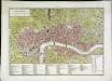
Londres (avec le bourg de Southwark)
1 Plan : Kupferdruck ; 26 x 45 cm, Bildgrösse 32 x 45 cm Mentelle; Tardieu; Dubuisson Mentelle
This actual survey of London Westminster Soutwark is humbly dedicated to y.e L.d Mayor [and] court of Aldermen
1 Plan auf 2 Blättern : Kupferdruck ; 58 x 98 cm chez Iean Cóvens et Corneille Mortier libraires et marchands des cartes
[A plan of London]
1 Plan : Kupferdruck ; 49 x 66 cm Rocque; Parr John Rocque
Rowe's map of London, westminster and Southwark, exhibiting the various improvements to the year 1804, detail showing the London and west india Docks
A canal and the two West India docks now cut across the neck of the Isle of Dogs to provide shipping with a shortcut across its marshy peninsular. A wall around its edge holds back the tidal Thames while windmills on the windy west side pump water from the marsh. As industry spreads, wealthy residents are lured away to the fashionable new suburbs rising to the west of London. Turnpikes appear, on the Hackney Road for example: an indication of the growing need for good roads and the money to maintain them. From the tangle of older streets, the line of the proposed new Commercial Road shoots straight across the open fields. Rowe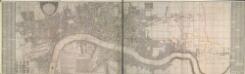
A New and Exact Plan of Ye City of LONDON and suburbs thereof, 1731 92
Map of London featuring title in semi-elliptical cartouche at top left, arms of the 12greatcity companies around the arms of the city at bottom left and explanatory note and compass star at bottom centre. The map is divided in squares with letters along the borders for reference. Reference tables feature down both sides of the map. Ward boundaries within the city and parish boundaries outside the city are highlighted in colour. The Tower of London, St Paul's Cathedral and other prominent buildings are represented pictorially. This is a later edition of the map first issued by Bowles in 1719, extended to the east to include Stepney and the Isle of Dogs. Bowles, Thomas

This Actuall Survey Of LONDON, WESTMINSTER AND SOUTHWARK Is humbly Dedicated To Y.e L.d M.Yor & Court Of Aldermen by R.o: Morden, Phil: Lea Chr: Browne
This is a later edition of a very popular map of London first published by Morden and Lea in 1690. The map's title features along the top, with the city arms at top left, facing the publisher's imprint in shield at top right. The reference tables, scale bar and compass rose appear at lower right. The plan marks the city's growth in the late Stuart period, showing its northward spread towards Islington. Morden, Robert & Lea, Philip
LONDON 76
This small map of London and suburbs was included in a small 1707French travel book, "Les Delices de la Grande Bretagne". It features a compass rose at bottom right, and a title with reference panel below the plan. Bevereel, James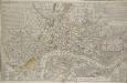
A NEW and CORRECT PLAN of the CITIES of LONDON, WESTMINSTER, and BOROUGH of SOUTHWARK wherein all the Streets, Roads, Churches, Public Buildings &c. to the Present Year 1791 are exactly delineated.
Map publisher and print seller Robert Sayer traded from Fleet Street in the latter half of the 18th century, first under his own name, and then under the joint imprint of Sayer& Bennett. This map has four-colour text panels in corners, including information relating to the recent Act for regulating Hackney Coaches. The development of turnpike roads in 1750 saw an increase of wheeled traffic, supplanting rivers as the main medium of transport. The map also features information about new rates for watermen introduced in 1785.The title of the plan states that it has been published as the "Act Directs”, a reference to the Copyright Act of 1734, used to curb the high incidence of uncredited copying among mapmakers. Sayer, Robert
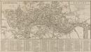
LONDON and its ENVIRONS 190
The title of this small map of Regency London appears at top right, facing a scale bar at top left. The map is divided into squares for reference. It indicates with a dotted line the proposed new bridge at Waterloo. Designed by John Rennie, Waterloo Bridge was constructed by a commercial company hoping to profit from toll-paying traffic. The bridge cost 1m and was never profitable. In 1936, amid controversy, the bridge was demolished and replaced.