Maps of Swindon

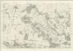
Swindon
1 : 31680 The author of this drawing, William Stanley, was listed as a 'first class' Military draughtsman and surveyor at the Tower of London Drawing Room. His elaborate hill shading technique for describing relief and the attention he pays to communications routes reinforce the military emphasis of these maps. Archaeological details are documented even though this did not become obligatory until 1816. The iron-age hillfort at Barbury Castle is described, along with numerous barrows and earthworks. Stanley, William
Marlborough (Hills) - OS One-Inch Revised New Series
1 : 63360 Topographic maps Ordnance Survey Ordnance Survey
Marlborough (Outline) - OS One-Inch Revised New Series
1 : 63360 Topographic maps Ordnance Survey Ordnance Survey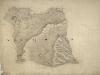
North Wilts
[E. Crocker]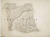
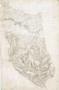
Broad Hinton and Avebury
This map features a stretch of the Wilts and Berks canal, before its route was appropriated for use by railway lines. Of the numerous ancient features on the map are the remains of the Druidical temple in Avesbury and the ancient encampments of Barbury castle and Byknoll (Bincknoll) castle. Crocker, E.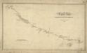
The Turnpike Road From Marlborough To Hungerford
1 : 31680 .Records from the Ordnance Survey Letter Book suggest that Edmund Crocker surveyed the turnpike road from Hungerford to Marlborough and William Stanley, draughtsman, made the drawing. The road is coloured yellow ochre and one side is thickened to indicate its importance. Notes of mileage in ink figures appear alongside the road. The close attention given to communication routes highlights the military emphasis of these studies. Stanley, William
SU28 - OS 1:25,000 Provisional Series Map
1 : 25000 Topographic maps Ordnance Survey Ordnance Survey
SU27 - OS 1:25,000 Provisional Series Map
1 : 25000 Topographic maps Ordnance Survey Ordnance Survey
SU26 - OS 1:25,000 Provisional Series Map
1 : 25000 Topographic maps Ordnance Survey Ordnance Survey
SU18 - OS 1:25,000 Provisional Series Map
1 : 25000 Topographic maps Ordnance Survey Ordnance Survey
SU17 - OS 1:25,000 Provisional Series Map
1 : 25000 Topographic maps Ordnance Survey Ordnance Survey
SU16 - OS 1:25,000 Provisional Series Map
1 : 25000 Topographic maps Ordnance Survey Ordnance Survey
A topographical map, of the county, of Berks, Blatt XII und XVIII
2 Blätter : 99 x 51 cm John Rocque
SU36 - OS 1:25,000 Provisional Series Map
1 : 25000 Topographic maps Ordnance Survey Ordnance Survey
SU37 - OS 1:25,000 Provisional Series Map
1 : 25000 Topographic maps Ordnance Survey Ordnance Survey
SU38 - OS 1:25,000 Provisional Series Map
1 : 25000 Topographic maps Ordnance Survey Ordnance Survey
Wiltshire X - OS Six-Inch Map
1 : 10560 Topographic maps Ordnance Survey Ordnance Survey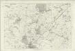
Wiltshire XV - OS Six-Inch Map
1 : 10560 Topographic maps Ordnance Survey Ordnance Survey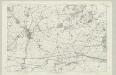
Wiltshire XXII - OS Six-Inch Map
1 : 10560 Topographic maps Ordnance Survey Ordnance Survey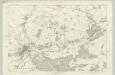
Wiltshire XXVIII - OS Six-Inch Map
1 : 10560 Topographic maps Ordnance Survey Ordnance Survey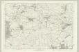
Wiltshire XXXV - OS Six-Inch Map
1 : 10560 Topographic maps Ordnance Survey Ordnance Survey
Berkshire XVIII - OS Six-Inch Map
1 : 10560 Topographic maps Ordnance Survey Ordnance Survey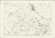
Wiltshire XVI - OS Six-Inch Map
1 : 10560 Topographic maps Ordnance Survey Ordnance Survey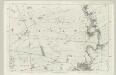
Wiltshire XXIII - OS Six-Inch Map
1 : 10560 Topographic maps Ordnance Survey Ordnance Survey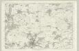
Wiltshire XXIX - OS Six-Inch Map
1 : 10560 Topographic maps Ordnance Survey Ordnance Survey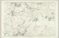
Wiltshire XXXVI - OS Six-Inch Map
1 : 10560 Topographic maps Ordnance Survey Ordnance Survey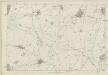
Berkshire XIX - OS Six-Inch Map
1 : 10560 Topographic maps Ordnance Survey Ordnance Survey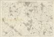
Berkshire XXV - OS Six-Inch Map
1 : 10560 Topographic maps Ordnance Survey Ordnance Survey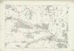
Wiltshire XXIV - OS Six-Inch Map
1 : 10560 Topographic maps Ordnance Survey Ordnance Survey
Wiltshire XXX - OS Six-Inch Map
1 : 10560 Topographic maps Ordnance Survey Ordnance Survey