Maps of Europe

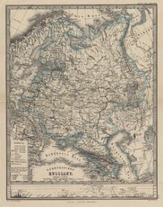
Europäisches Russland
1 : 16000000 Russland / Europäischer Teil
Europaeisches Russland mit Polen
Geographischer Atlas über alle Theile der Erde Ziegler, Jakob Melchior Verlag von Joh. Wurster um Comp.
Europaeisches Russland mit Polen
Geographischer Atlas über alle Theile der Erde Ziegler, Jakob Melchior Verlag von Dietrich Reimer
Russland
1 : 16000000 Russland / Europäischer Teil
Ruszland
1 : 12000000 Russland / Europäischer Teil
[Europ. Russland]
[Allgemeiner Atlas über alle Theile der Erde in 29 Blättern] Ziegler, Jakob Melchior Top. Anstalt v. J. Wurster u. Comp.
TABVLA | RVSSIÆ | ex autographo, quod delineandum | curavit Foedor filius Tzaris Boris desum- | ta; et ad fluvios Dwinam, Zuchanam, aliaque | loca, quantum ex tabulis ex notitiis ad nos dela- | tis fieri potuit, amplificata...
Amstelodami, | Excusum Apud Guiljelmum Blaeu
Russland
1 : 36000000 Russland / Europäischer Teil
Das europäische Russland
Schul-Atlas in 36 Karten Völter, Daniel Verlag der J.M. Dannheimer'schen Buchhandlung
Tabula Russiae ex autographo, quod delineandum curavit Foedor filius Tzaris Boris desumta [...] [Karte], in: Theatrum orbis terrarum, sive, Atlas novus, Bd. 1, S. 67.
1 Karte aus Atlas Blaeu, Joan Blaeu, Willem Janszoon
Karte der Bevölkerung Russlands im 19. Jahrhundert
Russland Bevölkerungsdichte
Sarmatische Tiefebene
Osteuropa, Ostmitteleuropa
Bodenbenutzung und Industrie
Russland / Europäischer Teil Industrie, Bodennutzung
Tabula Russiae ex mandato Foedor Borissovitsj delineata ... Magno domino, Tzari et magno duci Michäeli Foedrowits omnium Russorum autocratori... dedicata a Nicolao Ioannis Piscatore
1 : 10000000 Annotatie: Met breedte- en lengtegraden; Origineel is Blad 136 in atlas factice; Annotatie geografische gegevens: 2 schaalstokken: Wirst seu milliaria Russica en Milliaria Germanica; Inzet: Celeberrima ingens et imperialis civitas Moscua; Russche Narva sive Ivane-gorod; Archangel sive Archangelscka-goroda; Curia Imperatoris Russi appellata Kremelena-gorod; Hypocausta Russorum; Molendina Russorum Fjodor Borissovitsj Godoenov 17e E.; Claes Jansz. Visscher 1586/1587-1652 [S.l. : C.J. Visscher Excudebat]
Karte der Bevölkerung Russlands im 9. Jahrhundert
Russland Bevölkerungsdichte
Ost Europa
1 : 12500000 Russland / Europäischer Teil
Ruszland
1 : 18000000 Russland / Europäischer Teil
Europäisches Russland
Russland / Europäischer Teil
Wirtschaftskarten I. Rußland
1 : 18000000 Russland / Europäischer Teil Wirtschaft
Karte der Vergrösserungen Russlands unter Peter dem Grossen und seinen Nachfolgern
Russland Peter I.
Russland
Russland / Europäischer Teil
Europaeisches Russland
Plastischer Schul-Atlas über alle Theile der Erde : in 24 Karten Woldermann, G Verlag von P. Eckerlein
Russland
1 : 15225000 Russland / Europäischer Teil
Ravensteinkarte Osteuropa
1 : 3333333 Evropa střední a východní Ravensteins Geographische-Verlagsanstalt und Druckerei
Des Russischen Reichs Europäischer Theil
Stieler's Hand-Atlas Stieler, Adolf bei Justus Perthes
Soubor němých map pro gymnasia a odborné školy

Europaeisches Rusland
1 : 11800000 Asie západní Radefeld Bibliograph. Instituts
[Europaeisches Russland auch Schweden u. Norwegen, Dabei Uebersicht des Oesterreichischen u. Preussischen Staats]
Hand-Atlas über alle Theile der Erde nach dem neuesten Zustande und über das Weltgebäude Stieler, Adolf bei Justus Perthes
Russland
Russland / Europäischer Teil Skizzenbuch