Maps of Europe

Ruszland
1 : 12000000 Russland / Europäischer Teil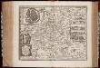
Tabula Russiae ex mandato Foedor Borissovitsj delineata ... Magno domino, Tzari et magno duci Michäeli Foedrowits omnium Russorum autocratori... dedicata a Nicolao Ioannis Piscatore
1 : 10000000 Annotatie: Met breedte- en lengtegraden; Origineel is Blad 136 in atlas factice; Annotatie geografische gegevens: 2 schaalstokken: Wirst seu milliaria Russica en Milliaria Germanica; Inzet: Celeberrima ingens et imperialis civitas Moscua; Russche Narva sive Ivane-gorod; Archangel sive Archangelscka-goroda; Curia Imperatoris Russi appellata Kremelena-gorod; Hypocausta Russorum; Molendina Russorum Fjodor Borissovitsj Godoenov 17e E.; Claes Jansz. Visscher 1586/1587-1652 [S.l. : C.J. Visscher Excudebat]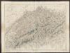
Tabula Russiae ex autographo, quod delineandum curavit Foedor filius Tzaris Boris desumta [...] [Karte], in: Theatrum orbis terrarum, sive, Atlas novus, Bd. 1, S. 67.
1 Karte aus Atlas Blaeu, Joan Blaeu, Willem Janszoon
Völkerkarte
Osteuropa Ethnische Gruppe
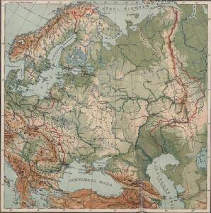
Russland
1 : 36000000 Russland / Europäischer Teil
Volkerkarte von Russland.
1 : 13300000 Andree, Richard
Bodenbenutzung und Industrie
Russland / Europäischer Teil Industrie, Bodennutzung
Europäisches Russland
1 : 16000000 Russland / Europäischer Teil
Mapa slovanského světa

Russland und Skandinavien
Handatlas über alle Theile der Erde und über das Weltgebäude Stieler, Adolf Justus Perthes
Mapa slovanského světa

Soubor němých map pro gymnasia a odborné školy

[Europaeisches Russland auch Schweden u. Norwegen]
Hand-Atlas über alle Theile der Erde nach dem neuesten Zustande und über das Weltgebäude Stieler, Adolf bei Justus Perthes
[Europaeisches Russland auch Schweden u. Norwegen, Dabei Uebersicht des Oesterreichischen u. Preussischen Staats]
Hand-Atlas über alle Theile der Erde nach dem neuesten Zustande und über das Weltgebäude Stieler, Adolf bei Justus Perthes
Europaeisches Russland mit Polen
Geographischer Atlas über alle Theile der Erde Ziegler, Jakob Melchior Verlag von Joh. Wurster um Comp.
Russland
1 : 16000000 Russland / Europäischer Teil
Sarmatische Tiefebene
Osteuropa, Ostmitteleuropa
Eastern Europe.
1 : 14495100 Fisher, Richard Swainson
Europaeisches Rusland
1 : 11800000 Asie západní Radefeld Bibliograph. Instituts
Mapa slovanského světa

Russland
Neuer Handatlas über alle Theile der Erde Kiepert, Heinrich Verlag von Dietrich Reimer
66-67. Russia.
1 : 7500000 Touring club italiano
Novissima Russiae Tabula [Karte], in: Gerardi Mercatoris et I. Hondii Newer Atlas, oder, Grosses Weltbuch, Bd. 1, S. 124.
1 Karte aus Atlas Mercator, Gerhard und Hondius, Jodocus Jansson, Jan
Composite: Russia, Finland.
1 : 6000000 John Bartholomew and Son
Etnografska karta na slavjanstvoto v Evropa
1 : 5000000 Evropa východní Florinskij, Timofej Dmitrijevič Slavjanska besěda
Tabula Russiae [...] [Karte] Moscua ad Architypum Foedori Borißowitsi [Planvedute, Karte], in: Le théâtre du monde, ou, Nouvel atlas contenant les chartes et descriptions de tous les païs de la terre, Bd. 1, S. 67.
1 Karte aus Atlas Blaeu, Willem Janszoon und Blaeu, Joan Blaeu, Willem Janszoon
Carte de la Pologne à son apogee, sous Sigismond-Auguste, en face du Principat de Russie sous le czar Ivan IV, vers l’an 1570 de notre ère
Polen Russland Polen-Litauen Zygmunt August
Europaeisches Russland
Plastischer Schul-Atlas über alle Theile der Erde : in 24 Karten Woldermann, G Verlag von P. Eckerlein
Novissima Russiae Tabula [Karte], in: Novus atlas absolutissimus, Bd. 1, S. 70.
1 Karte aus Atlas Janssonius Offizin