Maps of Europe

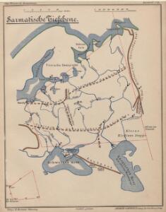
Sarmatische Tiefebene
Osteuropa, Ostmitteleuropa
Europaeisches Russland
Plastischer Schul-Atlas über alle Theile der Erde : in 24 Karten Woldermann, G Verlag von P. Eckerlein
Russland
Neuer Handatlas über alle Theile der Erde Kiepert, Heinrich Verlag von Dietrich Reimer
Eastern Europe.
1 : 14495100 Fisher, Richard Swainson
Das europäische Russland
Schul-Atlas in 36 Karten Völter, Daniel Verlag der J.M. Dannheimer'schen Buchhandlung
Tabula Russiae [...] [Karte] Moscua ad Architypum Foedori Borißowitsi [Planvedute, Karte], in: Le théâtre du monde, ou, Nouvel atlas contenant les chartes et descriptions de tous les païs de la terre, Bd. 1, S. 67.
1 Karte aus Atlas Blaeu, Willem Janszoon und Blaeu, Joan Blaeu, Willem Janszoon
Europäisches Russland
Russland / Europäischer Teil
Karte der Bevölkerung Russlands im 19. Jahrhundert
Russland Bevölkerungsdichte
Europaeisches Russland
E. von Sydow's Schul-Atlas in sechs und dreissig Karten Sydow, Emil von bei Justus Perthes
Europaeisches Russland
Grosser Hand-Atlas über alle Theile der Erde in 170 Karten Meyer, J. Verlag des Bibliographischen Instituts
Novissima Russiae Tabula [Karte], in: Novus atlas absolutissimus, Bd. 1, S. 70.
1 Karte aus Atlas Janssonius Offizin
Russland
1 : 36000000 Russland / Europäischer Teil
Tabula Russiae [...] [Karte] Moscua [Planvedute, [Nebenkarte], in: Novus Atlas, das ist, Weltbeschreibung, Bd. 1, S. 55.
1 Karte aus Atlas Blaeu, Joan Blaeu, Willem Janszoon
[Europ. Russland]
[Allgemeiner Atlas über alle Theile der Erde in 29 Blättern] Ziegler, Jakob Melchior Top. Anstalt v. J. Wurster u. Comp.
Rußland
1 : 18000000 Russland / Europäischer Teil
Karte der Bevölkerung Russlands im 9. Jahrhundert
Russland Bevölkerungsdichte
Russland
Volksschul-Atlas über alle Teile der Erde Lange, Henry Druck und Verlag von Georg Westermann
Europaeisches Russland mit Polen
Geographischer Atlas über alle Theile der Erde Ziegler, Jakob Melchior Verlag von Dietrich Reimer
Wirtschaftskarten I. Rußland
1 : 18000000 Russland / Europäischer Teil Wirtschaft
Europaeisches Russland mit Kasan, Astrachan und Georgien
Schul-Atlas über alle Theile der Erde nach dem neuesten Zustande, und über das Weltgebäude Stieler, Adolf Justus Perthes
Praktische Geschäfts und Reisekarte sämmtlicher Staaten von Europa enthaltend die vorzüglichsten Strassen-Verbindungen mit Angage der Distanzen und der bestehenden Eisenbahnen: Nebst einem Theile von Africa u. Asien, und zwar die Länder: Marocco, Algerien u. Tunis, ganz Kleinasien, und ein Theil von Persien
Schulz, R. A.
Tabula Russiae ex autographo, quod delineandum curavit Foedor filius Tzaris Boris desumta [...] [Karte], in: Theatrum orbis terrarum, sive, Atlas novus, Bd. 1, S. 67.
1 Karte aus Atlas Blaeu, Joan Blaeu, Willem Janszoon
Europaeisches Russland mit Polen
Geographischer Atlas über alle Theile der Erde Ziegler, Jakob Melchior Verlag von Joh. Wurster um Comp.
Rußland
1 : 18000000 Russland / Europäischer Teil
Novissima Russiae Tabula [Karte], in: Gerardi Mercatoris et I. Hondii Newer Atlas, oder, Grosses Weltbuch, Bd. 1, S. 124.
1 Karte aus Atlas Mercator, Gerhard und Hondius, Jodocus Jansson, Jan
Skandinavien und Rußland
1 : 18000000 Skandinavien, Osteuropa
Tabula Russiae ex mandato Foedor Borissovitsj delineata ... Magno domino, Tzari et magno duci Michäeli Foedrowits omnium Russorum autocratori... dedicata a Nicolao Ioannis Piscatore
1 : 10000000 Annotatie: Met breedte- en lengtegraden; Origineel is Blad 136 in atlas factice; Annotatie geografische gegevens: 2 schaalstokken: Wirst seu milliaria Russica en Milliaria Germanica; Inzet: Celeberrima ingens et imperialis civitas Moscua; Russche Narva sive Ivane-gorod; Archangel sive Archangelscka-goroda; Curia Imperatoris Russi appellata Kremelena-gorod; Hypocausta Russorum; Molendina Russorum Fjodor Borissovitsj Godoenov 17e E.; Claes Jansz. Visscher 1586/1587-1652 [S.l. : C.J. Visscher Excudebat]
Europäisches Russland
1 : 14500000 Russland / Europäischer Teil
Carta politica della Russia / Francesco Vallardi
1 : 3300000 Francesco Vallardi