Maps of Europe

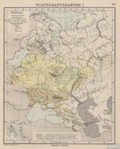
Wirtschaftskarten I. Rußland
1 : 18000000 Russland / Europäischer Teil Wirtschaft
Karte der Bevölkerung Russlands im 19. Jahrhundert
Russland Bevölkerungsdichte
Karte der Bevölkerung Russlands im 9. Jahrhundert
Russland Bevölkerungsdichte
Europäisches Russland
1 : 14500000 Russland / Europäischer Teil
Europäisches Russland
Russland / Europäischer Teil
Das europäische Russland
Schul-Atlas in 36 Karten Völter, Daniel Verlag der J.M. Dannheimer'schen Buchhandlung
Sarmatische Tiefebene
Osteuropa, Ostmitteleuropa
Praktische Geschäfts und Reisekarte sämmtlicher Staaten von Europa enthaltend die vorzüglichsten Strassen-Verbindungen mit Angage der Distanzen und der bestehenden Eisenbahnen: Nebst einem Theile von Africa u. Asien, und zwar die Länder: Marocco, Algerien u. Tunis, ganz Kleinasien, und ein Theil von Persien
Schulz, R. A.
Karte der Vergrösserungen Russlands unter Peter dem Grossen und seinen Nachfolgern
Russland Peter I.
Karte der Vergrösserungen Russlands unter Peter dem Grossen und seinen Nachfolgern
Russland Peter I.
Ruszland
1 : 18000000 Russland / Europäischer Teil
Europaeisches Russland
Plastischer Schul-Atlas über alle Theile der Erde : in 24 Karten Woldermann, G Verlag von P. Eckerlein
Europäisches Russland
1 : 13300000 Russland / Europäischer Teil
Europaeisches Russland mit Polen
Geographischer Atlas über alle Theile der Erde Ziegler, Jakob Melchior Verlag von Joh. Wurster um Comp.
Eastern Europe.
1 : 14495100 Fisher, Richard Swainson
[Europ. Russland]
[Allgemeiner Atlas über alle Theile der Erde in 29 Blättern] Ziegler, Jakob Melchior Top. Anstalt v. J. Wurster u. Comp.
Russland
Neuer Handatlas über alle Theile der Erde Kiepert, Heinrich Verlag von Dietrich Reimer
Europaeisches Russland mit Polen
Geographischer Atlas über alle Theile der Erde Ziegler, Jakob Melchior Verlag von Dietrich Reimer
Russland
1 : 15225000 Russland / Europäischer Teil
Russland seit Peters des Grossen Zeit
1 : 12000000 Russland
Europaeisches Russland mit Kasan, Astrachan und Georgien
Russland / Europäischer Teil
Rußland
1 : 18000000 Russland / Europäischer Teil
Tabula Russiae [...] [Karte] Moscua ad Architypum Foedori Borißowitsi [Planvedute, Karte], in: Le théâtre du monde, ou, Nouvel atlas contenant les chartes et descriptions de tous les païs de la terre, Bd. 1, S. 67.
1 Karte aus Atlas Blaeu, Willem Janszoon und Blaeu, Joan Blaeu, Willem Janszoon
Europäisches Russland
1 : 16000000 Russland / Europäischer Teil
Europaeisches Russland
E. von Sydow's Schul-Atlas in sechs und dreissig Karten Sydow, Emil von bei Justus Perthes
Novissima Russiae Tabula [Karte], in: Novus atlas absolutissimus, Bd. 1, S. 70.
1 Karte aus Atlas Janssonius Offizin
Carta politica della Russia / Francesco Vallardi
1 : 3300000 Francesco Vallardi
Europäisches Russland
1 : 20500000 Russland / Europäischer Teil
Europaeisches Russland
Grosser Hand-Atlas über alle Theile der Erde in 170 Karten Meyer, J. Verlag des Bibliographischen Instituts