Maps of Europe

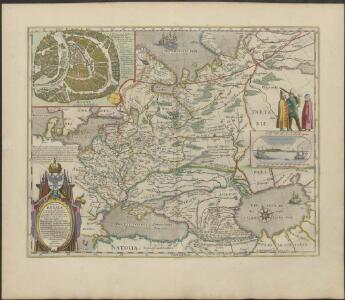
TABVLA | RVSSIÆ | ex autographo, quod delineandum | curavit Foedor filius Tzaris Boris desum- | ta; et ad fluvios Dwinam, Zuchanam, aliaque | loca, quantum ex tabulis ex notitiis ad nos dela- | tis fieri potuit, amplificata...
Amstelodami, | Excusum Apud Guiljelmum Blaeu
Russia.
1 : 7760000 Johnson, A.J.
Russia.
1 : 7760000 Johnson, A.J.
Karte der Bevölkerung Russlands im 9. Jahrhundert
Russland Bevölkerungsdichte
Europäisches Russland
1 : 16000000 Russland / Europäischer Teil
Karte der Bevölkerung Russlands im 19. Jahrhundert
Russland Bevölkerungsdichte
Ravensteinkarte Osteuropa
1 : 3333333 Evropa střední a východní Ravensteins Geographische-Verlagsanstalt und Druckerei
Russland
Russland / Europäischer Teil Skizzenbuch
Das europäische Russland
Schul-Atlas in 36 Karten Völter, Daniel Verlag der J.M. Dannheimer'schen Buchhandlung
Des Russischen Reichs Europäischer Theil
Stieler's Hand-Atlas Stieler, Adolf bei Justus Perthes
Tabula Russiae ex autographo, quod delineandum curavit Foedor filius Tzaris Boris desumta [...] [Karte], in: Theatrum orbis terrarum, sive, Atlas novus, Bd. 1, S. 67.
1 Karte aus Atlas Blaeu, Joan Blaeu, Willem Janszoon
Europaeisches Russland mit Polen
Geographischer Atlas über alle Theile der Erde Ziegler, Jakob Melchior Verlag von Dietrich Reimer
Europäisches Russland
1 : 14500000 Russland / Europäischer Teil
Karte der Vergrösserungen Russlands unter Peter dem Grossen und seinen Nachfolgern
Russland Peter I.
Karte der Vergrösserungen Russlands unter Peter dem Grossen und seinen Nachfolgern
Russland Peter I.
Russland
1 : 16000000 Russland / Europäischer Teil
Europaeisches Russland mit Polen
Geographischer Atlas über alle Theile der Erde Ziegler, Jakob Melchior Verlag von Joh. Wurster um Comp.
Ruszland
1 : 18000000 Russland / Europäischer Teil
Russland
Russland / Europäischer Teil
Europaeisches Russland mit Kasan, Astrachan und Georgien
Schul-Atlas über alle Theile der Erde nach dem neuesten Zustande, und über das Weltgebäude Stieler, Adolf bei Justus Perthes

Europaeisches Rusland
1 : 11800000 Asie západní Radefeld Bibliograph. Instituts
Russland
1 : 36000000 Russland / Europäischer Teil
Russia Europea: Carta politica-administrativa della Russia dei Sovieti nell 1923
1 : 5000000 Istituto Geografico de Agostini di C. Rossi e A.M. Boroli Visintin, L.
Europaeisches Russland mit Kasan, Astrachan und Georgien
Russland / Europäischer Teil
Russland Polen und Litthauen vom Untergang des Freistaats Nowgorod, 1478, und von der Auflösung der goldenen Horde, 1480, bis auf Peter den Grossen 1689
1 : 12000000 Russland, Polen-Litauen
Rußland im XVI. u. XVII. Jahrhundert
1 : 18000000 Russland
[Europ. Russland]
[Allgemeiner Atlas über alle Theile der Erde in 29 Blättern] Ziegler, Jakob Melchior Top. Anstalt v. J. Wurster u. Comp.
Soubor němých map pro gymnasia a odborné školy