Maps of Northern European Plain

Europäisches Russland 1801-1855
1 : 15500000 Russland / Europäischer Teil
Russland
Russland / Europäischer Teil Skizzenbuch
Charte des europäischen Russlands
Russland / Europäischer Teil
Europaeisches Russland mit Kasan, Astrachan und Georgien
Schul-Atlas über alle Theile der Erde nach dem neuesten Zustande, und über das Weltgebäude Stieler, Adolf bei Justus Perthes
Russisches Reich. Verwaltungsgrenzen von 1914. Europäischer Teil
Russland / Europäischer Teil Verwaltungsgliederung
Russland
Russland / Europäischer Teil
Russland
1 : 16000000 Russland / Europäischer Teil
Europäisches Russland
1 : 14500000 Russland / Europäischer Teil
Russia.
1 : 7760000 Johnson, A.J.
Russia.
1 : 7760000 Johnson, A.J.
Russland
1 : 15000000 Russland / Europäischer Teil
Ruszland
1 : 18000000 Russland / Europäischer Teil
Russland
1 : 15225000 Russland / Europäischer Teil
Karte der Vergrösserungen Russlands unter Peter dem Grossen und seinen Nachfolgern
Russland Peter I.
Europaeisches Russland mit Kasan, Astrachan und Georgien
Russland / Europäischer Teil
Ost Europa
1 : 12500000 Russland / Europäischer Teil
TABVLA | RVSSIÆ | ex autographo, quod delineandum | curavit Foedor filius Tzaris Boris desum- | ta; et ad fluvios Dwinam, Zuchanam, aliaque | loca, quantum ex tabulis ex notitiis ad nos dela- | tis fieri potuit, amplificata...
Amstelodami, | Excusum Apud Guiljelmum Blaeu
Europäisches Russland
1 : 16000000 Russland / Europäischer Teil
Mineralien
Russland / Europäischer Teil Mineralischer Rohstoff
Europäisches Russland
1 : 20500000 Russland / Europäischer Teil
La Russie d'Europe
Russland Bielaerts, J. B.
Karta rossijskich želěznych dorog
1 : 5250000 Charkov-oblast (Ukrajina) Bangof, Eduard v artističeskom zavedenija A.F. Marksa
Europaeisches Russland mit Polen
Geographischer Atlas über alle Theile der Erde Ziegler, Jakob Melchior Verlag von Joh. Wurster um Comp.
Ruszland
1 : 12000000 Russland / Europäischer Teil
Karte der Vergrösserungen Russlands unter Peter dem Grossen und seinen Nachfolgern
Russland Peter I.
Des Russischen Reichs Europäischer Theil
Stieler's Hand-Atlas Stieler, Adolf bei Justus Perthes
Ravensteinkarte Osteuropa
1 : 3333333 Evropa střední a východní Ravensteins Geographische-Verlagsanstalt und Druckerei

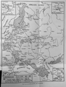
Das europæische Russland nach seiner allmähligen Vergrösserung seit 1462
1 : 38500000 Russland / Europäischer Teil Expansion