Maps of Frisian Islands

[Kaart], uit: Zuiderzeewerken : 10 K.L.M. luchtfoto's in briefkaartformaat = The drainage of the Zuyderzee : 10 airviews by K.L.M., postcards, real photographs
titelvariant: The drainage of the Zuyderzee; Annotatie: Foto's van werkzaamheden aan de Wieringermeerpolder en de Afsluitdijk, genomen in juli en okt. 1927 en febr. en mei 1928; Annotatie geografische gegevens: Plankaartje: Plan voor afsluiting en droogmaking van de de Zuiderzee = The drainage of the Zuyderzee Rotterdam : Fototechn. Dienst K.L.M. Vliegveld Waalhaven
Typus Frisiae veteris inter Rheni medium ostium et Amisiam itemque insulae Batavorum, ut fuerunt habitu terrarum et cultu, cum hic Romani, et postea Franci: rerum poterentur.
1 : 680000 [Bernardus Schotanus à Sterringa] [Amstelodami] : Franciscus Halma excudebat
The United Provinces or Netherlands
1 : 1500000 Mollova mapová sbírka Moll, Herman Moll, Hermann
Descriptio Agri Frisii antiqui aliorumque trans Rhenum qui hodie sunt in dicione VII Foederatorum
1 : 700000 auctore Mensone Alting. [Amstelaedami] : [apud Henricum Wetstenium]
Holland.
1 : 520000 Thomson, John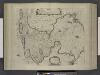
De Zuyder-zee.
from De zee-atlas ofte water-wereld : waer in vertoont werden alle de zee-kusten van het bekende des aerd-bodems : seer dienstigh voor alle heeren en kooplieden, als oock voor alle schippers en stuurlieden / by Pieter Goos.
Nieuwe kaart van Holland
1 : 675000 J.C. de Roeder, delin. H. Klockhoff, dir. sculp. 1792. [Amsterdam] : [Johannes Allart]
Hollandia
1 : 800000 [Pieter van den Keere engraver] [Amsterdam] : [Guglielmo de Jonge]
Hollandia Comitatus in ejusdem sujacentes ditiones : una cum toto Ultrajectino Domino, nec non maximis partibus Geldriae Ducatus, Frisiae Comitatus aliarumq vicinarum provinciarum foederatum exactissimè delinatus / per Nicolaum Visscher ; G. Gouwen sculps.
1 : 300000 titelvariant: Landkaart vertonende het graafschap Holland ...; Annotatie: Titel boven de kaart: Landkaart vertonende het graafschap Holland; Uit: Atlas minor, sive totius orbis terrarum. - Amstelaedami : apud Nicolaum Visscher, [na 1705]; Met privilege Visscher, Nicolaes (1649-1702); Gouwen, G. Amsterdam : Nicolaus Visscher
Hollandia
1 : 800000 [Pieter van den Keere engraver] [Amsterdam] : [Jan Evertsz. Cloppenburgh]
Nieuwe kaart van Holland tot het Vaderlandsch Woordenboek van Kok behoorende
1 : 675000 J.C. de Roeder, delin. H. Klockhoff, dir. sculp. 1792. [Amsterdam] : [Johannes Allart]
Kaart der Bataafse Republiek : verdeeld in departementen en ringen volgens de acte van staatsregeling bij publicatie van het Uitvoerend Bewind van den 17 Novemb. 1798 en in districten bij publicatie van den 14 Meij 1799
1 : 2000000 door Quint Ondaatje C. van Baarsel sculp[sit] Amst. In de Haag : bij J.C. Leeuwensteijn
Nieuwe kaart der Vereenigde Nederlanden.
1 : 1000000 Te Amsterdam : by Isaak Tirion
De VII. Vereenigde Nederlandsche Provincien

Belgii pars septentrionalis communi nomine vulgo Hollandia nuncupata continens statum potentissimae Batavorum reipublicae sev provincias VII foederatas
1 : 630000 Belgie Homann, Johann Baptist exhibente Io. Baptista Homanno
Belgii pars septentrionalis communi nomine vulgo Hollandia nuncupata continens statum potentissimae Batavorum reipublicae sev provincias VII foederatas
1 : 630000 Belgie Homann, Johann Baptist exhibente Io. Baptista Homanno
Vollständige Carte des gantzen Rhein Stroms
1 : 840000 Mollova mapová sbírka Riegel, Christoph Riegel, Christoph
Kaart van het Koningrijk der Nederlanden : aantoonende de wijze waarop en de plaatsen waarheen op 1e September 1856 briefpakketten worden verzonden of briefbestelling wordt verrigt op kosten van 's Rijks schatkist, benevens opgave waar op dat tijdstip E.M. telegraaf kantoren geopend waren
1 : 550000 ontworpen en geteekend door S. Gille Heringa op steen gebragt bij A.J. Bogaerts. Middelburg : J.G. en W. Altorffer
Hollandia
1 : 470000 Petrus Kerius. Amstelodami : Petrus Kerius excudebat
Kaart van het Koningrijk der Nederlanden : aantoonende de wijze waarop en de plaatsen waarheen op 1e Januarij 1857 briefpakketten worden verzonden of briefbestelling wordt verrigt op kosten van 's Rijks schatkist, benevens opgave waar op dat tijdstip E.M. telegraaf kantoren geopend waren
1 : 550000 ontworpen en geteekend door S. Gille Heringa op steen gebragt bij A.J. Bogaerts. Middelburg : J.G. en W. Altorffer
Hollandiae Comitatus in ejusdem subjacentes ditiones; una cum toto Ultrajectino Dominio, nec non maximis partibus Geldriæ Ducatus, Frisiæ Comitatus, aliarumq[ue] vicinarum provinciarum foederatarum; exactissimè delineatus = Landkaart vertonende het Graafschap Holland, seer dienstig om te reysen na, en van syne naburige provincien, als mede de hoven van Soestdyk, ’t Loo en Cleef
1 : 300000 per Nicolaum Visscher ... G. Gouwen schulp. t' Amsteldam : nunc apud Petrum Schenk Junior
Nieuwe Caerte waerinne vertoont wordt de gantsche Vaert van Amsterdam over de Watten tot de stadt Hamborch toe. [Karte, Teil 1], in: Novus atlas absolutissimus, Bd. 2, S. 95.
1 Karte aus Atlas Janssonius Offizin
Hollandiæ Comitatus in ejusdem subjacentes ditiones; una cum toto Ultrajectino Dominio, nec non maximis partibus Geldriæ Ducatus, Frisiæ Comitatus, aliarumq[ue] vicinarum provinciarum foederatarum; exactissimè delineatus
1 : 300000 per Nicolaum Visscher ... G. Gouwen schulp. t' Amsteldam : door Nicolaus Visscher [II]
Nieuwe Caerte waerinne vertoont wordt de gantsche Vaert van Amsterdam over de Watten tot de stadt Hamborch toe. [Karte, Teil 1], in: Gerardi Mercatoris et I. Hondii Newer Atlas, oder, Grosses Weltbuch, Bd. 1, S. 152.
1 Karte aus Atlas Mercator, Gerhard und Hondius, Jodocus Jansson, Jan
De VII Vereenigde Nederlandsche Provinciën
1 : 250000 naar de nieuwste meetingen naauwkeurig geteekend en in 't koper gebragt door Christiaan Sepp en Zoon. Te Amsterdam : by J.C. Sepp
De zeeven Neederlanden.
1 : 800000 [François Halma] [Leeuwarden] : [Hendrik Halma]
Holand
1 : 900000 [Sebastian Münster] [Basel] : [Heinrich Petri]
Hollandiae Antiquorum Catthorum Sedis Nova Descriptio [Karte], in: Theatrum orbis terrarum, S. 192.
1 Karte aus Atlas Ortelius, Abraham Vrients, Jan Baptista
Hollandiae Antiquorum Catthorum Sedis Nova Descriptio [Karte], in: Theatrum orbis terrarum, S. 52.
1 Karte aus Atlas Ortelius, Abraham
![[Kaart], uit: Zuiderzeewerken : 10 K.L.M. luchtfoto's in briefkaartformaat = The drainage of the Zuyderzee : 10 airviews by K.L.M., postcards, real photographs](https://images-0.georeferencer.com/images/iiif/749533514369/full/,300/0/native.jpg)

