Maps of Netherlands

Descriptio Agri Frisii antiqui aliorumque trans Rhenum qui hodie sunt in dicione VII Foederatorum
1 : 700000 auctore Mensone Alting. [Amstelaedami] : [apud Henricum Wetstenium]
Holland.
1 : 1300000 Lucas, Fielding Jr.
Charte des Königreichs Holland
1 : 650000 Nizozemsko Stieler, Adolf Streit, Friedrich Wilhelm
Charte des Königreichs Holland
1 : 650000 Nizozemsko Stieler, Adolf Streit, Friedrich Wilhelm
Charte des Königreichs Holland
1 : 650000 Nizozemsko Stieler, Adolf Streit, Friedrich Wilhelm
CHARTE des KÖNIGREICHS HOLLAND
1 : 640000 Nizozemsko Stieler, Adolf Streit, Friedrich Wilhelm
Charte des Königreichs Holland
1 : 650000 Nizozemsko Stieler, Adolf Streit, Friedrich Wilhelm
Charte des Königreichs Holland
1 : 650000 Nizozemsko Stieler, Adolf Streit, Friedrich Wilhelm
Charte der Hollaendischen départemens
Nizozemsko Kipferling, Karl Joseph Krayenhoff, Cornelius Rudolphus Theodorus J. Riedl's Kunsthandung
Charte der Hollaendischen départemens
Nizozemsko Krayenhoff, Cornelius Rudolphus Theodorus Verlage des Kunst und Industrie
Descriptio Frisiae sub Francorum reditum qua hodie VII Foederator. est
1 : 950000 auctore Mensone Alting Ger. de Broen fec. Amstel. [Amstelaedami] : [apud Henricum Wetstenium]
Holland.
1 : 1457280 Lucas, Fielding Jr.
Nouvelle carte des departements de Hollande et des départemens circonvoisins de l'Empire Francais = Nieuwe kaart der departementen van Holland, en die der omliggende van het Fransche keizerrijk
1 : 760000 W.C. van Baarsel del. et sc. A Amsterdam : chez E. Maaskamp
Nieuwe aardrykskundige kaart van het Koningryk Holland in deszelfs geheel grondgebied met het voormalig Oost-Friesland, Jeverland, Kniphuisen en Varel
1 : 700000 naar de jongste Staats-verdragen door Jacob de Gelder A Zürcher sculp. Te Amsterdam : by Johs. Allart en Jacs. Ruis
[Nizozemsko]
Nizozemsko
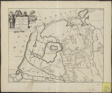
Typus Frisiae veteris inter Rheni medium ostium et Amisiam itemque insulae Batavorum, ut fuerunt habitu terrarum et cultu, cum hic Romani, et postea Franci: rerum poterentur.
1 : 680000 [Bernardus Schotanus à Sterringa] [Amstelodami] : Franciscus Halma excudebat
Holland.
1 : 1300000 Darton, William
Karte von Holland nach der letzten Gränz-Berichtigung verfasst
1 : 970000 Nizozemsko Tranq. Mollo
Spoorwegkaart van het Koningrijk der Nederlanden
1 : 1000000 lith. van L.J. Tordoir. Zwolle : Zeehuisen
The United Provinces or Netherlands and Arx Britannica.
1 : 1450000 Moll, Herman, d. 1732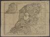
[ République Batave]
1 : 750000 Tardieu, Jean Baptiste Pierre 1746-1816 [Paris] : [Edme Mentelle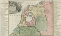
Descriptio Frisiae sub Francorum reditum qua hodie VII Foederator est
1 : 550000 Mollova mapová sbírka Alting, Menso
Bladwijzer van de kaarten op de schaal van 1:25 000, 1:50 000 en 1:200 000
1 : 600000 Nizozemsko Topogr. Inrichting

Foederatae Belgicae tabvla
1 : 728000 Limburg (Belgie) Wit, Frederick de F. de Wit
Holland.
1 : 1048000 Hughes, William
Holland.
1 : 1290000 Finley, Anthony
Seven United Provinces.
1 : 1460000 Bowen, Frances
Holland.
1 : 520000 Thomson, John