Maps of North Holland

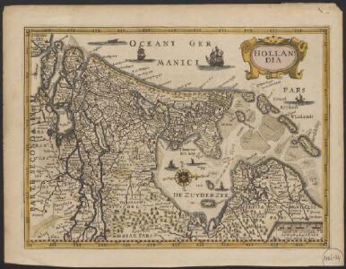
Hollandia
1 : 800000 [Pieter van den Keere engraver] [Amsterdam] : [Guglielmo de Jonge]
Hollandia
1 : 800000 [Pieter van den Keere engraver] [Amsterdam] : [Jan Evertsz. Cloppenburgh]
Hollandia Comitatus in ejusdem sujacentes ditiones : una cum toto Ultrajectino Domino, nec non maximis partibus Geldriae Ducatus, Frisiae Comitatus aliarumq vicinarum provinciarum foederatum exactissimè delinatus / per Nicolaum Visscher ; G. Gouwen sculps.
1 : 300000 titelvariant: Landkaart vertonende het graafschap Holland ...; Annotatie: Titel boven de kaart: Landkaart vertonende het graafschap Holland; Uit: Atlas minor, sive totius orbis terrarum. - Amstelaedami : apud Nicolaum Visscher, [na 1705]; Met privilege Visscher, Nicolaes (1649-1702); Gouwen, G. Amsterdam : Nicolaus Visscher
Holand
1 : 900000 [Sebastian Münster] [Basel] : [Heinrich Petri]
Hollandiae Antiquorum Catthorum Sedis Nova Descriptio [Karte], in: Theatrum orbis terrarum, S. 192.
1 Karte aus Atlas Ortelius, Abraham Vrients, Jan Baptista
Hollandiae Antiquorum Catthorum Sedis Nova Descriptio [Karte], in: Theatrum orbis terrarum, S. 52.
1 Karte aus Atlas Ortelius, Abraham
Hollandia
1 : 470000 Petrus Kerius. Amstelodami : Petrus Kerius excudebat
Holandt
1 : 900000 [Sebastian Münster] [Basel] : [Heinrich Petri]
Holãd
1 : 900000 [Sebastian Münster] [Basel] : [Heinrich Petri]
Holãd
1 : 900000 [Sebastian Münster] [Basel] : [Heinrich Petri]
Bescrivinge van dat vermarde en vruchtbaer graefschap van Hollant met dat geheele landt van Utrecht, dese landen sin eertiets bij den ouden Romeinen Batavia genaemt geweest, waer af dat het landt tusschen den Rhin ende de Wael noch tertiet den naem Betue behouden heeft, want gelick men noch tegenwordich sien can dat den Rhin in voerleden tijden doer Utrecht ende de stadt Leijden also sijnen cours oft loop aldaer inde zee genomen heeft, bij dat huus te Bretta, waer vã noch somige rowinen oft oude muragien inde zee liggê die welcke bij onsen tydê dry mael gesien sin te wetê int jaer 1520 eñ 1552 1562
1 : 400000 Joannes à Duetecum, Lucas à Duetecum fecerunt Nieumegen. [S.l.] : [s.n.]
Holand
1 : 900000 [Sebastian Münster] [Basel] : [Heinrich Petri]
Comitatus Hollandia = ’t Graefschap Hollandt
1 : 400000 van nieus verb. ende verm. door Willem Janszoon [Blaeu] Josua vanden Ende sculpsit. Amsterdam : ghedruckt bij Willem Jansz. op 't water inde Sonnewijser
Hollandiae antiquorum catthorum sedis nova descriptio, auctore Iacobo a Daventria
1 : 400000 [Abraham Ortelius] [engraver: Frans Hogenberg] [Antwerpen] : [Abraham Ortelius ; Gilles Coppens van Diest]
Kaart der Bataafse Republiek : verdeeld in departementen en ringen volgens de acte van staatsregeling bij publicatie van het Uitvoerend Bewind van den 17 Novemb. 1798 en in districten bij publicatie van den 14 Meij 1799
1 : 2000000 door Quint Ondaatje C. van Baarsel sculp[sit] Amst. In de Haag : bij J.C. Leeuwensteijn
Hollandia Comitatus
1 : 550000 [Willem Jansz. Blaeu] Josua vanden Ende sculpsit. T'Amsterdami : by Rombout van den Hoeye
Hollandiae antiquorum catthorum sedis nova descriptio, auctore Iacobo a Daventria
1 : 400000 [Abraham Ortelius] [engraver Frans Hogenberg] [Antwerpen] : [Abraham Ortelius ; Gilles Coppens van Diest]
Hollandiae Comitatus in ejusdem subjacentes ditiones; una cum toto Ultrajectino Dominio, nec non maximis partibus Geldriæ Ducatus, Frisiæ Comitatus, aliarumq[ue] vicinarum provinciarum foederatarum; exactissimè delineatus = Landkaart vertonende het Graafschap Holland, seer dienstig om te reysen na, en van syne naburige provincien, als mede de hoven van Soestdyk, ’t Loo en Cleef
1 : 300000 per Nicolaum Visscher ... G. Gouwen schulp. t' Amsteldam : nunc apud Petrum Schenk Junior
Hollandiæ Comitatus in ejusdem subjacentes ditiones; una cum toto Ultrajectino Dominio, nec non maximis partibus Geldriæ Ducatus, Frisiæ Comitatus, aliarumq[ue] vicinarum provinciarum foederatarum; exactissimè delineatus
1 : 300000 per Nicolaum Visscher ... G. Gouwen schulp. t' Amsteldam : door Nicolaus Visscher [II]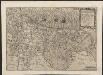
Hollãdiæ integra comita descript.
1 : 400000 [Gerard and Cornelis de Jode] [Antwerpen] : [Widow and heirs Gerard de Jode]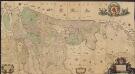
Comitatus Hollandiæ et Dominii Ultraiectini tabula
1 : 60000 [Jacob Aertsz. Colom] Amstelodami : ex officina I. Côvens et C. Mortier vulgo de Vygendam
[Kaart], uit: Zuiderzeewerken : 10 K.L.M. luchtfoto's in briefkaartformaat = The drainage of the Zuyderzee : 10 airviews by K.L.M., postcards, real photographs
titelvariant: The drainage of the Zuyderzee; Annotatie: Foto's van werkzaamheden aan de Wieringermeerpolder en de Afsluitdijk, genomen in juli en okt. 1927 en febr. en mei 1928; Annotatie geografische gegevens: Plankaartje: Plan voor afsluiting en droogmaking van de de Zuiderzee = The drainage of the Zuyderzee Rotterdam : Fototechn. Dienst K.L.M. Vliegveld Waalhaven
Nieuwe kaart van Holland
1 : 675000 J.C. de Roeder, delin. H. Klockhoff, dir. sculp. 1792. [Amsterdam] : [Johannes Allart]
The United Provinces or Netherlands
1 : 1500000 Mollova mapová sbírka Moll, Herman Moll, Hermann
Hollandia
1 : 700000 Henricus Nagel fecit. [Keulen] : Joan Bussemchr [!] exc.
Hollandiae chorographia
1 : 750000 [Jodocus Hondius sr.] [Amsterdam] : [Jodocus Hondius sr.]
Hollandiae antiquorum catthorum sedis nova descriptio, auctore Iacobo a Daventria
1 : 400000 [Abraham Ortelius] [Frans Hogenberg, engraver] [Antwerpen] : [Abraham Ortelius]
Comitatus Hollandiae Nova Descriptio. Ex Optimis & novißimis Delineationibus designata [Karte], in: Novus atlas absolutissimus, Bd. 3, S. 159.
1 Karte aus Atlas Janssonius Offizin
Hollandiæ comitatus Hollant grafschaftt
1 : 1000000 [Frans Hogenberg] [Keulen] : [s.n.]