Maps of Lesser Sunda Islands
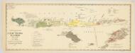
Schets-taalkaart van de Kleine Soenda Eilanden / vervaardigd door K.F. Holle, Adviseur Honorair, voor Inlandsche Zaken, naar gegevens van de Ambtenaren van Binnenlandsch Bestuur en met medewerking van het Topographisch Bureau te Batavia
1 : 1500000 Annotatie: Behoort bij het Koloniaal Verslag van 1893; Annotatie geografische gegevens: Legenda Batavia : Topographisch Bureau
Kleine Soenda Eilanden : aangevende het aantal inrichtingen voor Inlandsch Onderwijs op 31 december 1914 / Top[ographische] Inr[ichting]
Topographische Inrichting Batavia Batavia : Top[ographische] Inr[ichting]
Kaart der zuyd-wester eylanden van Banda
1 : 1700000 [Dordrecht etc.] : J. van Braam et G. o. Linden exc.
Carte hypsométrique de l'Archipel des Indes Orientales / par P. Melvill de Carnbee
La Haye : Heyse
Flores, Soemba, Timor

Singaradja / U.S. Army Map Service
U.S. Army Map Service Washington D.C. Washington D.C. : U.S. Army Map Service
Singaradja / samengesteld en gedrukt bij den Topografischen Dienst
Topografische Dienst Batavia Batavia : Topografische Dienst
Koepang / U.S. Army Map Service
U.S. Army Map Service Washington D.C. Washington D.C. : U.S. Army Map Service
Koepang / Topografische Dienst
Topografische Dienst Batavia Batavia : Reproductiebedrijf Topografische Dienst
Koepang / Topografische Dienst
Topografische Dienst Batavia Batavia : Reproductiebedrijf Topografische Dienst
Schetskaart van Nederlandsch Timor en omliggende eilanden / Topographische Inrichting
Topografische Inrichting Batavia Batavia : Topographische Inrichting
15. Kaart van de Kleine Soenda Eilanden, uit: Atlas van Nederlandsch Oost-Indië / samengest. door Topographisch Bureau te Batavia van 1897-1904
Annotatie: Omgewerkte versie van: Atlas der Nederlandsche bezittingen in Oost-Indië / naar de nieuste bronnen samengest. door J.W. Stemfoort en J.J. ten Siethoff. - 's-Gravenhage : Topographische Inrichting, [ca. 1885] Topographisch Bureau, Batavia 's-Gravenhage : Topographische Inrichting
Raba / Survey of India
Survey of India [S.l.] : Survey of India
Banjoewangi / Survey of India
Survey of India [S.l.] : Survey of India
Kaart van het eiland Flores / door A. Wichmann
Koninklijk Nederlandsch Aardrijkskundig Genootschap Amsterdam Leiden : E.J. Brill
Res. Timor en Onderh., Blad 88/XLIX-L [243-244], uit: Res. Timor en onderh
1 : 100000 Annotatie: Aanwezig: 3 bladen West-Timor en 4 bladen Roti; Annotatie geografische gegevens: Geografische plaatsbepaling t.o.v. de 0-meridiaan van Batavia; Op elk blad een kaartje met de administratieve indeling tot het niveau van landschappen Batavia : Topografische dienst
Kaart van de eilanden Balie en Lombok
1 : 650000 [Groningen] : ter steendrukkerij van A. Oomkens, J. zoon
Heteiland Flores / J.G. veth, del. 1874
Aardrijkskundig Genootschap Amsterdam Amsterdam : C.F. Stemler
Kaart van een gedeelte van het eiland Timor met de grenzen op dat eiland van het Nederlandsch en Portugeesch gebied volgens het tractaat van 1 october 1904
Koninklijk Nederlandsch Aardrijkskundig Genootschap Amsterdam Leiden : Boekhandel en Drukkerij voorheen E.J. Brill
Kaart van het Eiland Soemba / Topographisch Bureau, januari 1897 ; [Met aantekening in pen: herziene herdruk juli 1897 door H.D.H. Bosboom]
Topographisch Bureau Batavia Batavia : Topographisch Bureau
Schetskaart van het eiland Soemba / Topographische Inrichting
Topographische Inrichting Batavia Batavia : Topographische Inrichting
Essai sur la géographie de l'Île Timor
Havajské ostrovy Freycinet, L. de
Dilly / Survey of India
Survey of India [S.l.] : Survey of India
Kaart van het Eiland Timor / zamengesteld door G.H. Heymering ; lith[ographie] door C. Franz
Batavia : Lith[ographie] der Genie
Ilha de Timor / desenhada por Antonio Aug. de Santos Victal
[S.l. : Repartiçao das Obras Publicas Timor]
Carta da provincia de Timor
1 : 1000000 Timor (Indonésie) Ministerio das colonias
Ilha de Timor / desenhada Antonio Aug. de Santos Victal
Dilly : [s.n.]
Postiljon Eilanden / Survey of India
Survey of India [S.l.] : Survey of India
Sitoebondo / Survey of India
Survey of India [S.l.] : Survey of India


