Maps of Ruteng

Res. Timor en Onderh., Blad 88/XLIX-L [243-244], uit: Res. Timor en onderh
1 : 100000 Annotatie: Aanwezig: 3 bladen West-Timor en 4 bladen Roti; Annotatie geografische gegevens: Geografische plaatsbepaling t.o.v. de 0-meridiaan van Batavia; Op elk blad een kaartje met de administratieve indeling tot het niveau van landschappen Batavia : Topografische dienst
Bladwijzer van Onderafd[eeling] Ende-Ngada en Noord en West Mangerai
[S.l. : s.n.]
Peta Daerah Manggarai : Flores-Barat / oleh Pastor W. Janssen S.V.D. dengan pertolongan beberapa saudara-saudara jang lain
[S.l. : s.n.]
[Mangir] / [Topographisch Bureau]
Topographisch Bureau Batavia [Batavia] : [Topographisch Bureau]
Kaart van het eiland Flores / door A. Wichmann
Koninklijk Nederlandsch Aardrijkskundig Genootschap Amsterdam Leiden : E.J. Brill
Heteiland Flores / J.G. veth, del. 1874
Aardrijkskundig Genootschap Amsterdam Amsterdam : C.F. Stemler
Schetskaart van het eiland Soemba / Topographische Inrichting
Topographische Inrichting Batavia Batavia : Topographische Inrichting
Kaart van het Eiland Soemba / Topographisch Bureau, januari 1897 ; [Met aantekening in pen: herziene herdruk juli 1897 door H.D.H. Bosboom]
Topographisch Bureau Batavia Batavia : Topographisch Bureau
Schetskaart van het eiland Soemba / Top[ographische] Inr[ichting]
Topografische Inrichting Batavia Bat[avia] : Top[ographische] Inr[ichting]
Carte hypsométrique de l'Archipel des Indes Orientales / par P. Melvill de Carnbee
La Haye : Heyse
Kaart der zuyd-wester eylanden van Banda
1 : 1700000 [Dordrecht etc.] : J. van Braam et G. o. Linden exc.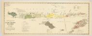
Schets-taalkaart van de Kleine Soenda Eilanden / vervaardigd door K.F. Holle, Adviseur Honorair, voor Inlandsche Zaken, naar gegevens van de Ambtenaren van Binnenlandsch Bestuur en met medewerking van het Topographisch Bureau te Batavia
1 : 1500000 Annotatie: Behoort bij het Koloniaal Verslag van 1893; Annotatie geografische gegevens: Legenda Batavia : Topographisch Bureau
Flores, Soemba, Timor

Raba / Survey of India
Survey of India [S.l.] : Survey of India
Koepang / Topografische Dienst
Topografische Dienst Batavia Batavia : Reproductiebedrijf Topografische Dienst
Koepang / U.S. Army Map Service
U.S. Army Map Service Washington D.C. Washington D.C. : U.S. Army Map Service
Koepang / Topografische Dienst
Topografische Dienst Batavia Batavia : Reproductiebedrijf Topografische Dienst
Benteng / Survey of India
Survey of India [S.l.] : Survey of India
Overzichtskaart van de Afdeeling Soemba : (behoort tot de Res[identie] Timor en Onderh[oorigheden] / Topografische Dienst
Topografische Dienst Weltevreden (Batavia) Weltevreden (Batavia) : Reproductiebedrijf Topografische Dienst
Waikaboebak ; Waingapoe / prepared under the direction of the Chief Engineers, U.S. Army by the Army Map Service, 1943 ; reproduced by 110 Map Production Co[mpan]y R.E. ; Survey Production Centre South East Asia, 1945
US Army Map Service Washington D.C. Washington D.C. : U.S. Army Map Service
Schetskaart van het Eiland Soemba / Topographische Inrichting
Topographische Inrichting Batavia Batavia : Topographische Inrichting
Postiljon Eilanden / Survey of India
Survey of India [S.l.] : Survey of India
Tossi ; Waikaboebak / prepared and reproduced by Base Map Plant, USASOS, SWPA, February, 1943, from Dutch map printed by Topografische Dienst (Topographic section), Batavia 1938
Base Map Plant USASOS SWPA [S.l.] : Base Map Plant USASOS/SWPA
Kleine Soenda Eilanden : aangevende het aantal inrichtingen voor Inlandsch Onderwijs op 31 december 1914 / Top[ographische] Inr[ichting]
Topographische Inrichting Batavia Batavia : Top[ographische] Inr[ichting]
Algemeene schetskaart van Nederlandsch-Indië : Gouv[ernement] Groote Oost, Res[identie] Manado / Topografische Dienst, Batavia
[S.l. : s.n.]
Celebes, de Kleine Soenda-Eilanden / Geogr[aphische] lithogr[aphie] v[an] E. de Geest
Seyffardt's Boekhandel Amsterdam Amsterdam : Lith[ographische] Drukkerij van Seyffardt's Boekhandel te Amsterdam
Reduzirte Karte vom SUNDA- ODER BORNEO-MEERE
1 : 2250000 Borneo Berghaus, Heinrich Karl Wilhelm Jättnig, Wilhelm J. Perthes
Reduzirte Karte vom Sunda- Oder Borneo-Meere und den Strassen zur Verbindung desselben mit dem Indischen und dem Chinesischen Meere, der Macassar-Strasse &c, zugleich als Karte von Djava, den kleinen Sunda-Inseln, Celebes, &c, &c.
1 : 2356000 dem .. Admiral Krusenstern [...] gewidmet von H. Berghaus gest. v. W. Jättnig Gotha : Perthes
Geologische schetskaart van het oostelijke gedeelte van den Nederlandsch-Indischen Archipel / door Dr. R.D.M. Verbeek
Topographische Inrichting Batavia [Batavia : Landsdrukkerij]
![Res. Timor en Onderh., Blad 88/XLIX-L [243-244], uit: Res. Timor en onderh](https://images-2.georeferencer.com/images/iiif/704653654621/full/,300/0/native.jpg)

