Maps of Lower Franconia

Kissingen 100, uit: Special-Karte von Mittel-Europa / nach amtlichen Quellen bearbeitet von W. Liebenow
1 : 300000 titelvariant: W. Liebenow's Mittel-Europa; Annotatie: Titel boven de bladen: W. Liebenow's Mittel-Europa Johannes Wilhelm Liebenow 1822-1897 Frankfurt a. M. : Ludwig Ravenstein
Kissingen 100, uit: [W. Liebenow's Special-Karte von Mittel-Europa]
1 : 300000 titelvariant: W. Liebenow's Mittel-Europa; Annotatie: Titel boven de bladen: W. Liebenow's Mittel-Europa Johannes Wilhelm Liebenow 1822-1897 Hannover : Hermann Oppermann

Buchaviae, sive Fuldensis Ditionis Typus. [Karte], in: Theatrum orbis terrarum, S. 144.
1 Karte aus Atlas Ortelius, Abraham

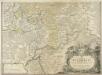
Nova et accuratior repraesentatio geographica Sacr. Rom. Imperii episcopatus Würceburgensis Franciae orientalis ducatus cum omnibus suis praefecturis, et ditionibus eo pertinentibus etc
1 : 380000 Württembersko (Německo) Lotter, Tobias Conrad impensis Tobiae Conradi Lotteri
Nova et accuratior repraesentatio geographica Sacr. Rom. Imperii episcopatus Würceburgensis Franciae orientalis ducatus cum omnibus suis praefecturis, et ditionibus eo pertinentibus etc
1 : 380000 Württembersko (Německo) Lotter, Tobias Conrad impensis Tobiae Conradi Lotteri
Reverendissimo Et Celsissimo S. R. I. Principi Constantino Sanctae Fuldensis Ecclesiae Abbati Augustissimae Romanorum Imperatricis Archi-Cancellario Per Germaniam Galliamque Primati Hanc Novam Veteris Buchoniae Tabulam Unacum Suis Confinys Dedicat Consecratque
1 : 340000 Mollova mapová sbírka Schannat, Johann Friedrich Puschner, Johann Georg
Buchaviae, sive Fuldensis Ditionis Typus. [Karte], in: Theatrum orbis terrarum, S. 236.
1 Karte aus Atlas Ortelius, Abraham Vrients, Jan Baptista
Das Bisthum Wurtzburg in Francken
1 : 280000 Mollova mapová sbírka Seyfried, Johann Heinrich Schollenberger, Johann Jakob Hoffmann, Johann
Fulda
1 : 300000 R. Mittelbach
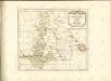
Charte von dem Grosgerzogthum Würzburg, nebst dem Fürstenthum Schwarzenberg, den Grafschafften Castell und Limpurg-Speckfeld, der Herrschafft Wiesentheid &c
1 : 188000 Bavorsko (Německo) Hammer, C. F. bey Homanns Erben
S. R. I. Principatvs Fvldensis in Bvchonia
1 : 210000 Mollova mapová sbírka Homann, Johann Baptist Homann, Johann Baptista
Das Franken-Weinland
1 : 505000 Bavorsko (Německo) Hellrung, Carl Ludwig Baensch, E. Rubach'schen Buchhandlung
S.R.I. principatus Fuldensis in Buchonia
1 : 206000 Fulda (Německo) Homann, Johann Baptist Ioh. Baptista Homanno
S. R. I. Principatvs Fvldensis in Bvchonia
1 : 210000 Mollova mapová sbírka Homann, Johann Baptist Homann, Johann Baptista
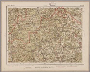
140. Schweinfurt, uit: Topographische Uebersichtskarte des Deutschen Reiches / herausgegeben v. d. Kartogr. Abt. d. Königl. Preuß. Landesaufnahme
1 : 200000 titelvariant: Topogr. Übersichtskarte des Deutschen Reiches; Annotatie: Titel boven bladen ook: Topogr. Übersichtskarte des Deutschen Reiches; Annotatie geografische gegevens: Op elk blad twee maatstokken: 10 Kilometer = 5,5 cm; 1 geogr. Meile = 3,6 cm; Legenda onder op elk blad Königlich Preußische Landesaufnahme. Kartographische Abtheilung [S.l : Königlich Preußische Landesaufnahme, Kartographische Abtheilung]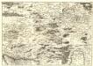
S. R. Imp. Circuli Franconici Geographica Delineatio Francken-Land mit Seinen Gräntzen
Mollova mapová sbírka Endter, Wolfgang Moritz Endter, Wolfgang Moritz
Der Lauf des Mains
1 : 370000 Aschaffenburg (Německo) Spruner, Karl von Verlag der Stahel'schen Buchhandlung

Reverendissimo Et Celsissimo S. R. I. Principi Adolfo Sanctae Fuldensis Ecclesiae Abbati Augustissimae Romanorum Imperatricis Archi-Cancellario Per Germaniam Galliamque Primati hanc Eius Ditionis Simul Ac Dioecisis Tabulam Geographicam Monumentis Historicis Illustratam
1 : 230000 Mollova mapová sbírka Schannat, Johann Friedrich
Das Franken-Weinland
1 : 493000 Bavorsko (Německo) Hellrung, Carl Ludwig Baensch, E. Rubach'schen Buchhandlung
Delineatio Geographica generalis comprehendens VI. Foliis Singulos Principatvs Comitatvs Ditiones Dynastias omnes quotquot Imperio Serenissimi Principis Landgrafii Hasso-Darmstadiensis subsunt :
1 : 180000 Mollova mapová sbírka Bronner, Christian Maximilian Homann, Johann Baptista - dědici

S. R. Imp. comitatus Hanau
1 : 190000 Büdingen (Německo) Zollmann, Friedrich Homann, Johann Baptist J. B. Homann
S. R. Imp. comitatus Hanau
1 : 190000 Büdingen (Německo) Zollmann, Friedrich Homann, Johann Baptist J. B. Homann
Bvchaviae, siue Fvldensis ditionis typvs
1 Karte : Kupferdruck ; 30 x 21 cm Regerwyl; Ortelius s.n.