Maps of Landkreis Fulda

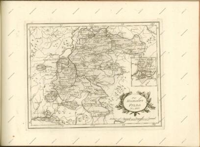
S. R. I. Principatvs Fvldensis in Bvchonia
1 : 210000 Mollova mapová sbírka Homann, Johann Baptist Homann, Johann Baptista
Reverendissimo Et Celsissimo S. R. I. Principi Adolfo Sanctae Fuldensis Ecclesiae Abbati Augustissimae Romanorum Imperatricis Archi-Cancellario Per Germaniam Galliamque Primati hanc Eius Ditionis Simul Ac Dioecisis Tabulam Geographicam Monumentis Historicis Illustratam
1 : 230000 Mollova mapová sbírka Schannat, Johann Friedrich
S.R.I. principatus Fuldensis in Buchonia
1 : 206000 Fulda (Německo) Homann, Johann Baptist Ioh. Baptista Homanno
Bvchaviae, siue Fvldensis ditionis typvs
1 Karte : Kupferdruck ; 30 x 21 cm Regerwyl; Ortelius s.n.
S. R. I. Principatvs Fvldensis in Bvchonia
1 : 210000 Mollova mapová sbírka Homann, Johann Baptist Homann, Johann Baptista
163 Fulda, uit: Topographische Special-Karte von Deutschland (von Central-Europa) / begründet von D.G. Reymann ; [entworfen und gezeichn. von Heinrich Berghaus... [et al.]]
1 : 200000 Annotatie: Lit.: Daniel Gottlob Reymann und die "Topographische Special-Karte von Deutschland" / von Wolfgang Scharfe, in: Kartographische Nachrichten, 39 (1989), Heft I, p. 1-10; Handgeschreven titel: Reymann's Deutschland : 24 Sectionen: Jena, Penig, Dresden, Zittau, Hirschberg, Breslau, Brieg, Andernach, Coblenz, Giessen, Fulda, Schleusingen, Plauen, Zwickau, Teplitz, Jung Bunzlau, Hohenelbe, Glatz, Neisse, Simmern, Prag, Luxemburg, Birkenfeld; Aanwezig: 23 bladen Reymann, Daniel Gottlob; Berghaus, Heinrich [Berlin : 2. Departement des Kriegsministeriums, Bureau für Plan- und Kartenzeichnung]
126. Fulda, uit: Topographische Uebersichtskarte des Deutschen Reiches / herausgegeben v. d. Kartogr. Abt. d. Königl. Preuß. Landesaufnahme
1 : 200000 titelvariant: Topogr. Übersichtskarte des Deutschen Reiches; Annotatie: Titel boven bladen ook: Topogr. Übersichtskarte des Deutschen Reiches; Annotatie geografische gegevens: Op elk blad twee maatstokken: 10 Kilometer = 5,5 cm; 1 geogr. Meile = 3,6 cm; Legenda onder op elk blad Königlich Preußische Landesaufnahme. Kartographische Abtheilung [S.l : Königlich Preußische Landesaufnahme, Kartographische Abtheilung]
Neueste Karte des heiligen Kreuzberges und seiner Umgebungen, mit den Rhoengebirgen und angrenzenden Orten
1 : 225000 Rhön (Německo) Richter, Johann Stephan Johann Stephan Richter
140. Schweinfurt, uit: Topographische Uebersichtskarte des Deutschen Reiches / herausgegeben v. d. Kartogr. Abt. d. Königl. Preuß. Landesaufnahme
1 : 200000 titelvariant: Topogr. Übersichtskarte des Deutschen Reiches; Annotatie: Titel boven bladen ook: Topogr. Übersichtskarte des Deutschen Reiches; Annotatie geografische gegevens: Op elk blad twee maatstokken: 10 Kilometer = 5,5 cm; 1 geogr. Meile = 3,6 cm; Legenda onder op elk blad Königlich Preußische Landesaufnahme. Kartographische Abtheilung [S.l : Königlich Preußische Landesaufnahme, Kartographische Abtheilung]
[Dolní Franky]
1 : 219000 Bad Kissingen (Německo) Loehle, Johann Kunstanstalt von Piloty u. Loehle
Gefechte bei Zella und Rossdorf, 4.Juli 1866
1 : 25000 Topograph. Bureau des k.b. Generalquartiermeister-Stabes
Gefecht bei Hünfeld
1 : 25000 Huber, J.; Popp, A.; Hoffmann, C.
Meßtischblatt 5723 : Altengronau, 1942
1 : 250000 Altengronau. - Bericht. 1937, hrsg. 1939, Ausg. 1942. - 1:25000. - [Berlin]: Reichsamt für Landesaufnahme, 1942. - 1 Kt.
Meßtischblatt 3282 : Schlüchtern, 1906
1 : 250000 Schlüchtern. - Aufn. 1904. - 1:25000. - [Berlin]: Kgl. Preuss. Landesaufnahme, 1906. - 1 Kt.
Meßtischblatt 3281 : Steinau, 1935
1 : 250000 Steinau. - Hrsg. 1906, einz. Nachtr. 1935. - 1:25000. - [Berlin]: Reichsamt für Landesaufnahme, 1935. - 1 Kt.
Meßtischblatt 5527 : Ostheim v. d. Rhön, 1952
1 : 250000 Ostheim v. d. Rhön. - Hrsg. 1906. - 1:25000. - [Berlin]: Vermessungsdienst des Landes Sachsen-Anhalt, 1952. - 1 Kt.
Meßtischblatt 428 : Ostheim, 1874
1 : 250000 Ostheim. - Aufn. 1857. - 1:25000. - [Berlin]: Kgl. Preuss. Min. f. Handel, 1874. - 1 Kt.
Meßtischblatt 5525 : Gersfeld, 1936
1 : 250000 Gersfeld. - Hrsg. 1906, bericht. 1926, einz. Nachtr. 1936. - 1:25000. - [Berlin]: Reichsamt für Landesaufnahme, 1936. - 1 Kt.
Meßtischblatt Gersfeld
1 : 250000 Gersfeld. - Aufn. 1869. - 1:25000. - [Berlin]: Reichsamt für Landesaufnahme, 1874. - 1 Kt.
Meßtischblatt 3227 : Neuhof, 1939
1 : 250000 Neuhof. - Hrsg. 1906, Ausg. 1939. - 1:25000. - [Berlin]: Reichsamt für Landesaufnahme, 1939. - 1 Kt.
Meßtischblatt 3227 : Neuhof, 1929
1 : 250000 Neuhof. - Hrsg. 1906, bericht. 1929. - 1:25000. - [Berlin]: Reichsamt für Landesaufnahme, 1929. - 1 Kt.
Meßtischblatt Freiensteinau (Hintersteinau)
1 : 250000 Freiensteinau (Hintersteinau). - Bearb. 1911, Nachtr. 1928, einz. Nachtr. 1933. - 1:25000. - Darmstadt: Hess. Landesvermessungsamt, 1933. - 1 Kt.
Meßtischblatt 5427 : Helmershausen, 1940
1 : 250000 Helmershausen. - Aufn. 1904, hrsg. 1906. - 1:25000. - [Berlin]: Reichsamt für Landesaufnahme, 1940. - 1 Kt.
Meßtischblatt 3175 . Helmershausen, 1906
1 : 250000 Helmershausen. - Aufn. 1904. - 1:25000. - [Berlin]: Kgl. Preuss. Landesaufnahme, 1906. - 1 Kt.
Meßtischblatt 3175 : Helmershausen, 1878
1 : 250000 Helmershausen. - Aufn. 1857, hrsg. 1874, bericht. 1878. - 1:25000. - [Berlin]: Kgl. Preuss. Min. f. Handel, 1878. - 1 Kt.
Meßtischblatt 5426 : Hilders, 1953
1 : 250000 Hilders. - Hrsg. 1906, letzte Nachtr. 1936, redakt. Änd. 1953 . - 1:25000. - [Berlin]: MdI, 1953. - 1 Kt.
Meßtischblatt 3174 : Hilders, 1906
1 : 250000 Hilders. - Aufn. 1904. - 1:25000. - [Berlin]: Reichsamt für Landesaufnahme, 1906. - 1 Kt.
Meßtischblatt 3173 : Kleinsassen, 1907
1 : 250000 Kleinsassen. - Aufn. 1905. - 1:25000. - [Berlin]: Kgl. Preuss. Landesaufnahme, 1907. - 1 Kt.