Maps of Landkreis Fulda


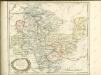
Buchaviae, sive Fuldensis Ditionis Typus. [Karte], in: Theatrum orbis terrarum, S. 144.
1 Karte aus Atlas Ortelius, Abraham
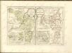
Buchaviae, sive Fuldensis Ditionis Typus. [Karte], in: Theatrum orbis terrarum, S. 236.
1 Karte aus Atlas Ortelius, Abraham Vrients, Jan Baptista
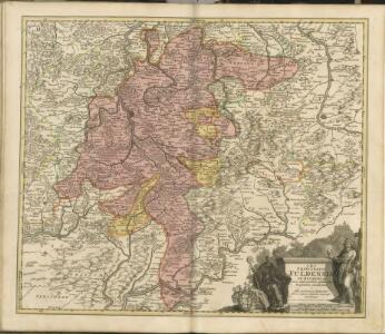
Reverendissimo Et Celsissimo S. R. I. Principi Constantino Sanctae Fuldensis Ecclesiae Abbati Augustissimae Romanorum Imperatricis Archi-Cancellario Per Germaniam Galliamque Primati Hanc Novam Veteris Buchoniae Tabulam Unacum Suis Confinys Dedicat Consecratque
1 : 340000 Mollova mapová sbírka Schannat, Johann Friedrich Puschner, Johann Georg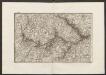
Militair Karte von Süd-Deutschland in 20 Sectionen
1 : 400000 2. Section Coulon, Alois von A. von Coulon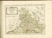

Fulda
1 : 300000 R. Mittelbach
S.R.I. principatus Fuldensis in Buchonia
1 : 206000 Fulda (Německo) Homann, Johann Baptist Ioh. Baptista Homanno
Kissingen 100, uit: Special-Karte von Mittel-Europa / nach amtlichen Quellen bearbeitet von W. Liebenow
1 : 300000 titelvariant: W. Liebenow's Mittel-Europa; Annotatie: Titel boven de bladen: W. Liebenow's Mittel-Europa Johannes Wilhelm Liebenow 1822-1897 Frankfurt a. M. : Ludwig Ravenstein
Kissingen 100, uit: [W. Liebenow's Special-Karte von Mittel-Europa]
1 : 300000 titelvariant: W. Liebenow's Mittel-Europa; Annotatie: Titel boven de bladen: W. Liebenow's Mittel-Europa Johannes Wilhelm Liebenow 1822-1897 Hannover : Hermann Oppermann
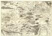
S. R. I. Principatvs Fvldensis in Bvchonia
1 : 210000 Mollova mapová sbírka Homann, Johann Baptist Homann, Johann Baptista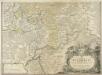
S. R. I. Principatvs Fvldensis in Bvchonia
1 : 210000 Mollova mapová sbírka Homann, Johann Baptist Homann, Johann Baptista
Reverendissimo Et Celsissimo S. R. I. Principi Adolfo Sanctae Fuldensis Ecclesiae Abbati Augustissimae Romanorum Imperatricis Archi-Cancellario Per Germaniam Galliamque Primati hanc Eius Ditionis Simul Ac Dioecisis Tabulam Geographicam Monumentis Historicis Illustratam
1 : 230000 Mollova mapová sbírka Schannat, Johann Friedrich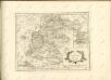
S. R. Imp. Circuli Franconici Geographica Delineatio Francken-Land mit Seinen Gräntzen
Mollova mapová sbírka Endter, Wolfgang Moritz Endter, Wolfgang Moritz
Bvchaviae, siue Fvldensis ditionis typvs
1 Karte : Kupferdruck ; 30 x 21 cm Regerwyl; Ortelius s.n.
140. Schweinfurt, uit: Topographische Uebersichtskarte des Deutschen Reiches / herausgegeben v. d. Kartogr. Abt. d. Königl. Preuß. Landesaufnahme
1 : 200000 titelvariant: Topogr. Übersichtskarte des Deutschen Reiches; Annotatie: Titel boven bladen ook: Topogr. Übersichtskarte des Deutschen Reiches; Annotatie geografische gegevens: Op elk blad twee maatstokken: 10 Kilometer = 5,5 cm; 1 geogr. Meile = 3,6 cm; Legenda onder op elk blad Königlich Preußische Landesaufnahme. Kartographische Abtheilung [S.l : Königlich Preußische Landesaufnahme, Kartographische Abtheilung]
Le Landgraviat de Hesse-Cassel Meridional et Septentr: avec une Partie du Landgraviat de Hesse-Darmstat et de la Vetteravie avec autres dependences
1 : 200000 Mollova mapová sbírka Carlet, Louis-François Lotter, Tobias Conrad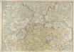
S. R. I. Principatvs Fvldensis in Bvchonia
1 : 210000 Mollova mapová sbírka Homann, Johann Baptist Homann, Johann Baptista
Principatus Hennenbergensis
1 : 300000 Mollova mapová sbírka Hondius, Henricus Schenk, Peter I
Principatus Hennenbergensis
1 : 300000 Mollova mapová sbírka Hondius, Henricus Janssonius, Johannes I
S. R. I. Comitatvs Henneberg
1 : 150000 Mollova mapová sbírka Zinck, Johann Jacob Homann, Johann Baptista - dědici
S. R. I. Comitatvs Henneberg
1 : 150000 Mollova mapová sbírka Zinck, Johann Jacob Homann, Johann Baptista - dědici
126. Fulda, uit: Topographische Uebersichtskarte des Deutschen Reiches / herausgegeben v. d. Kartogr. Abt. d. Königl. Preuß. Landesaufnahme
1 : 200000 titelvariant: Topogr. Übersichtskarte des Deutschen Reiches; Annotatie: Titel boven bladen ook: Topogr. Übersichtskarte des Deutschen Reiches; Annotatie geografische gegevens: Op elk blad twee maatstokken: 10 Kilometer = 5,5 cm; 1 geogr. Meile = 3,6 cm; Legenda onder op elk blad Königlich Preußische Landesaufnahme. Kartographische Abtheilung [S.l : Königlich Preußische Landesaufnahme, Kartographische Abtheilung]
163 Fulda, uit: Topographische Special-Karte von Deutschland (von Central-Europa) / begründet von D.G. Reymann ; [entworfen und gezeichn. von Heinrich Berghaus... [et al.]]
1 : 200000 Annotatie: Lit.: Daniel Gottlob Reymann und die "Topographische Special-Karte von Deutschland" / von Wolfgang Scharfe, in: Kartographische Nachrichten, 39 (1989), Heft I, p. 1-10; Handgeschreven titel: Reymann's Deutschland : 24 Sectionen: Jena, Penig, Dresden, Zittau, Hirschberg, Breslau, Brieg, Andernach, Coblenz, Giessen, Fulda, Schleusingen, Plauen, Zwickau, Teplitz, Jung Bunzlau, Hohenelbe, Glatz, Neisse, Simmern, Prag, Luxemburg, Birkenfeld; Aanwezig: 23 bladen Reymann, Daniel Gottlob; Berghaus, Heinrich [Berlin : 2. Departement des Kriegsministeriums, Bureau für Plan- und Kartenzeichnung]
Neueste Karte des heiligen Kreuzberges und seiner Umgebungen, mit den Rhoengebirgen und angrenzenden Orten
1 : 225000 Rhön (Německo) Richter, Johann Stephan Johann Stephan Richter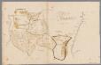
Ungefährlicher Entwurf den Ämbter Alssfeldt, Rümrodt, Grebenau, der Gerichte Schwarz und von Süsser Gerichte
1 : 35000 [S.l. : s.n.]
[Dolní Franky]
1 : 219000 Bad Kissingen (Německo) Loehle, Johann Kunstanstalt von Piloty u. Loehle