Maps of Landkreis Fulda

Bvchaviae, siue Fvldensis ditionis typvs
1 Karte : Kupferdruck ; 30 x 21 cm Regerwyl; Ortelius s.n.
Reverendissimo Et Celsissimo S. R. I. Principi Adolfo Sanctae Fuldensis Ecclesiae Abbati Augustissimae Romanorum Imperatricis Archi-Cancellario Per Germaniam Galliamque Primati hanc Eius Ditionis Simul Ac Dioecisis Tabulam Geographicam Monumentis Historicis Illustratam
1 : 230000 Mollova mapová sbírka Schannat, Johann Friedrich
S. R. I. Principatvs Fvldensis in Bvchonia
1 : 210000 Mollova mapová sbírka Homann, Johann Baptist Homann, Johann Baptista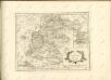

Gefecht bei Hünfeld
1 : 25000 Huber, J.; Popp, A.; Hoffmann, C.
Meßtischblatt 5723 : Altengronau, 1942
1 : 250000 Altengronau. - Bericht. 1937, hrsg. 1939, Ausg. 1942. - 1:25000. - [Berlin]: Reichsamt für Landesaufnahme, 1942. - 1 Kt.
Meßtischblatt 3282 : Schlüchtern, 1906
1 : 250000 Schlüchtern. - Aufn. 1904. - 1:25000. - [Berlin]: Kgl. Preuss. Landesaufnahme, 1906. - 1 Kt.
Meßtischblatt 3281 : Steinau, 1935
1 : 250000 Steinau. - Hrsg. 1906, einz. Nachtr. 1935. - 1:25000. - [Berlin]: Reichsamt für Landesaufnahme, 1935. - 1 Kt.
Meßtischblatt 3227 : Neuhof, 1939
1 : 250000 Neuhof. - Hrsg. 1906, Ausg. 1939. - 1:25000. - [Berlin]: Reichsamt für Landesaufnahme, 1939. - 1 Kt.
Meßtischblatt 3227 : Neuhof, 1929
1 : 250000 Neuhof. - Hrsg. 1906, bericht. 1929. - 1:25000. - [Berlin]: Reichsamt für Landesaufnahme, 1929. - 1 Kt.
Meßtischblatt Freiensteinau (Hintersteinau)
1 : 250000 Freiensteinau (Hintersteinau). - Bearb. 1911, Nachtr. 1928, einz. Nachtr. 1933. - 1:25000. - Darmstadt: Hess. Landesvermessungsamt, 1933. - 1 Kt.
Meßtischblatt 3172 : Fulda, 1907
1 : 250000 Fulda. - Aufn. 1905. - 1:25000. - [Berlin]: Kgl. Preuss. Landesaufnahme, 1907. - 1 Kt.
Meßtischblatt 3171, neue Nr. 5423 : Großenlüder, 1936
1 : 250000 Großenlüder. - Hrsg. 1907, bericht. 1910, einzelne Nachtr. 1930. - 1:25000. - [Berlin]: Reichsamt für Landesaufnahme, 1936. - 1 Kt.
Meßtischblatt Hosenfeld
1 : 250000 Hosenfeld. - Aufn. 1906. - 1:25000. - [Berlin]: Kgl. Preuss. Landesaufnahme, 1908. - 1 Kt.
Meßtischblatt 3113 : Hünfeld, 1908
1 : 250000 Hünfeld. - Aufn. 1905. - 1:25000. - [Berlin]: Kgl. Preuss. Landesaufnahme, 1907. - 1 Kt.
Meßtischblatt 3112 : Salzschlirf, 1908
1 : 250000 Salzschlirf. - Aufn. 1906. - 1:25000. - [Berlin]: Kgl. Preuss. Landesaufnahme, 1908. - 1 Kt.
Meßtischblatt 3051 : Eiterfeld, 1936
1 : 250000 Eiterfeld. - Hrsg. 1907, bericht. 1910, einzelne Nachtr. 1936. - 1:25000. - [Berlin]: Reichsamt für Landesaufnahme, 1936. - 1 Kt.
Meßtischblatt 5223 : Queck (Breitenbach a. Herzberge), 1926
1 : 250000 Queck (Breitenbach a. Herzberge). - Bearb. 1906 - 1907, Nachtr. 1926. - 1:25000. - [Berlin]: Reichsamt für Landesaufnahme, 1926. - 1 Kt.
Meßtischblatt 3049 : Lingelbach, 1908
1 : 250000 Lingelbach. - Aufn. 1906. - 1:25000. - [Berlin]: Kgl. Preuss. Landesaufnahme, 1908. - 1 Kt.
Meßtischblatt 5525 : Gersfeld, 1936
1 : 250000 Gersfeld. - Hrsg. 1906, bericht. 1926, einz. Nachtr. 1936. - 1:25000. - [Berlin]: Reichsamt für Landesaufnahme, 1936. - 1 Kt.
Meßtischblatt Gersfeld
1 : 250000 Gersfeld. - Aufn. 1869. - 1:25000. - [Berlin]: Reichsamt für Landesaufnahme, 1874. - 1 Kt.
Meßtischblatt 3173 : Kleinsassen, 1907
1 : 250000 Kleinsassen. - Aufn. 1905. - 1:25000. - [Berlin]: Kgl. Preuss. Landesaufnahme, 1907. - 1 Kt.
Meßtischblatt 3114 : Spahl, 1907
1 : 250000 Spahl. - Aufn. 1905, hrsg. 1907. - 1:25000. - [Berlin]: Reichsamt für Landesaufnahme, 1907. - 1 Kt.
Meßtischblatt 3114 : Neuswarts, 1874
1 : 250000 Neuswarts. - Aufn. 1857. - 1:25000. - Berlin: Kraatz, 1874. - 1 Kt.
Meßtischblatt 5225 : Geisa, 1953
1 : 250000 Geisa. - Aufn. 1905, hrsg. 1907, letzte Nachtr. 1936, redakt. Änd. 1953. - 1:25000. - [S.l.]: HA Verm. u. Kartenw., 1953. - 1 Kt.
Meßtischblatt 3ß52 : Geisa, 1907
1 : 250000 Geisa. - Aufn. 1905. - 1:25000. - [Berlin]: Kgl. Preuss. Landesaufnahme, 1907. - 1 Kt.
Meßtischblatt 3052 : Geisa, 1872
1 : 250000 Geisa. - Aufn. 1857. - 1:25000. - Berlin: Kraatz, 1872. - 1 Kt.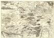
S. R. Imp. Circuli Franconici Geographica Delineatio Francken-Land mit Seinen Gräntzen
Mollova mapová sbírka Endter, Wolfgang Moritz Endter, Wolfgang Moritz
S.R.I. principatus Fuldensis in Buchonia
1 : 206000 Fulda (Německo) Homann, Johann Baptist Ioh. Baptista Homanno


