Maps of Landkreis Fulda

Maps of Landkreis Fulda

$title$

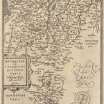
Buchaviae, sive Fuldensis Ditionis Typus. [Karte], in: Theatrum orbis terrarum, S. 236.

1 Karte aus Atlas Ortelius, Abraham Vrients, Jan Baptista
$title$

Buchaviae, sive Fuldensis Ditionis Typus. [Karte], in: Theatrum orbis terrarum, S. 144.

1 Karte aus Atlas Ortelius, Abraham
$title$

$title$

Reverendissimo Et Celsissimo S. R. I. Principi Constantino Sanctae Fuldensis Ecclesiae Abbati Augustissimae Romanorum Imperatricis Archi-Cancellario Per Germaniam Galliamque Primati Hanc Novam Veteris Buchoniae Tabulam Unacum Suis Confinys Dedicat Consecratque

1 : 340000 Mollova mapová sbírka Schannat, Johann Friedrich Puschner, Johann Georg
$title$

Militair Karte von Süd-Deutschland in 20 Sectionen

1 : 400000 2. Section Coulon, Alois von A. von Coulon
$title$

Kissingen 100, uit: [W. Liebenow's Special-Karte von Mittel-Europa]

1 : 300000 titelvariant: W. Liebenow's Mittel-Europa; Annotatie: Titel boven de bladen: W. Liebenow's Mittel-Europa Johannes Wilhelm Liebenow 1822-1897 Hannover : Hermann Oppermann
$title$

Fulda

1 : 300000 R. Mittelbach
$title$

S.R.I. principatus Fuldensis in Buchonia

1 : 206000 Fulda (Německo) Homann, Johann Baptist Ioh. Baptista Homanno
$title$

Kissingen 100, uit: Special-Karte von Mittel-Europa / nach amtlichen Quellen bearbeitet von W. Liebenow

1 : 300000 titelvariant: W. Liebenow's Mittel-Europa; Annotatie: Titel boven de bladen: W. Liebenow's Mittel-Europa Johannes Wilhelm Liebenow 1822-1897 Frankfurt a. M. : Ludwig Ravenstein
$title$

S. R. I. Principatvs Fvldensis in Bvchonia

1 : 210000 Mollova mapová sbírka Homann, Johann Baptist Homann, Johann Baptista
$title$

$title$

S. R. Imp. Circuli Franconici Geographica Delineatio Francken-Land mit Seinen Gräntzen

Mollova mapová sbírka Endter, Wolfgang Moritz Endter, Wolfgang Moritz
$title$

S. R. I. Principatvs Fvldensis in Bvchonia

1 : 210000 Mollova mapová sbírka Homann, Johann Baptist Homann, Johann Baptista
$title$

Reverendissimo Et Celsissimo S. R. I. Principi Adolfo Sanctae Fuldensis Ecclesiae Abbati Augustissimae Romanorum Imperatricis Archi-Cancellario Per Germaniam Galliamque Primati hanc Eius Ditionis Simul Ac Dioecisis Tabulam Geographicam Monumentis Historicis Illustratam

1 : 230000 Mollova mapová sbírka Schannat, Johann Friedrich
$title$

$title$

Bvchaviae, siue Fvldensis ditionis typvs

1 Karte : Kupferdruck ; 30 x 21 cm Regerwyl; Ortelius s.n.
$title$

140. Schweinfurt, uit: Topographische Uebersichtskarte des Deutschen Reiches / herausgegeben v. d. Kartogr. Abt. d. Königl. Preuß. Landesaufnahme

1 : 200000 titelvariant: Topogr. Übersichtskarte des Deutschen Reiches; Annotatie: Titel boven bladen ook: Topogr. Übersichtskarte des Deutschen Reiches; Annotatie geografische gegevens: Op elk blad twee maatstokken: 10 Kilometer = 5,5 cm; 1 geogr. Meile = 3,6 cm; Legenda onder op elk blad Königlich Preußische Landesaufnahme. Kartographische Abtheilung [S.l : Königlich Preußische Landesaufnahme, Kartographische Abtheilung]
$title$

S. R. I. Principatvs Fvldensis in Bvchonia

1 : 210000 Mollova mapová sbírka Homann, Johann Baptist Homann, Johann Baptista
$title$

163 Fulda, uit: Topographische Special-Karte von Deutschland (von Central-Europa) / begründet von D.G. Reymann ; [entworfen und gezeichn. von Heinrich Berghaus... [et al.]]

1 : 200000 Annotatie: Lit.: Daniel Gottlob Reymann und die "Topographische Special-Karte von Deutschland" / von Wolfgang Scharfe, in: Kartographische Nachrichten, 39 (1989), Heft I, p. 1-10; Handgeschreven titel: Reymann's Deutschland : 24 Sectionen: Jena, Penig, Dresden, Zittau, Hirschberg, Breslau, Brieg, Andernach, Coblenz, Giessen, Fulda, Schleusingen, Plauen, Zwickau, Teplitz, Jung Bunzlau, Hohenelbe, Glatz, Neisse, Simmern, Prag, Luxemburg, Birkenfeld; Aanwezig: 23 bladen Reymann, Daniel Gottlob; Berghaus, Heinrich [Berlin : 2. Departement des Kriegsministeriums, Bureau für Plan- und Kartenzeichnung]
$title$

126. Fulda, uit: Topographische Uebersichtskarte des Deutschen Reiches / herausgegeben v. d. Kartogr. Abt. d. Königl. Preuß. Landesaufnahme

1 : 200000 titelvariant: Topogr. Übersichtskarte des Deutschen Reiches; Annotatie: Titel boven bladen ook: Topogr. Übersichtskarte des Deutschen Reiches; Annotatie geografische gegevens: Op elk blad twee maatstokken: 10 Kilometer = 5,5 cm; 1 geogr. Meile = 3,6 cm; Legenda onder op elk blad Königlich Preußische Landesaufnahme. Kartographische Abtheilung [S.l : Königlich Preußische Landesaufnahme, Kartographische Abtheilung]
$title$

Le Landgraviat de Hesse-Cassel Meridional et Septentr: avec une Partie du Landgraviat de Hesse-Darmstat et de la Vetteravie avec autres dependences

1 : 200000 Mollova mapová sbírka Carlet, Louis-François Lotter, Tobias Conrad
$title$

Neueste Karte des heiligen Kreuzberges und seiner Umgebungen, mit den Rhoengebirgen und angrenzenden Orten

1 : 225000 Rhön (Německo) Richter, Johann Stephan Johann Stephan Richter
$title$

[Dolní Franky]

1 : 219000 Bad Kissingen (Německo) Loehle, Johann Kunstanstalt von Piloty u. Loehle
$title$

Ungefährlicher Entwurf den Ämbter Alssfeldt, Rümrodt, Grebenau, der Gerichte Schwarz und von Süsser Gerichte

1 : 35000 [S.l. : s.n.]
$title$

Territorium Abbatiae Heresfeldensis. 't Stift Hirszfeldt. [Karte], in: Novus Atlas, das ist, Weltbeschreibung, Bd. 1, S. 153.

1 Karte aus Atlas Blaeu, Joan Blaeu, Willem Janszoon
$title$

Territorium Abbatiae Heresfeldensis. 't Stift Hirßfeldt. [Karte], in: Theatrum orbis terrarum, sive, Atlas novus, Bd. 1, S. 242.

1 Karte aus Atlas Blaeu, Joan Blaeu, Willem Janszoon
$title$

Territorium Abbatiae Heresfeldensis. 't Stift Hirßfeldt. [Karte], in: Le théâtre du monde, ou, Nouvel atlas contenant les chartes et descriptions de tous les païs de la terre, Bd. 1, S. 184.

1 Karte aus Atlas Blaeu, Willem Janszoon und Blaeu, Joan Blaeu, Willem Janszoon
$title$

Abbatia Heresfeldensis. vulgo 't Stifftt Hirsfeldt. [Karte], in: Gerardi Mercatoris et I. Hondii Newer Atlas, oder, Grosses Weltbuch, Bd. 1, S. 295.

1 Karte aus Atlas Mercator, Gerhard und Hondius, Jodocus Jansson, Jan
$title$

Territorium Abbatiae Heresfeldensis. 't Stift Hirßfeldt. [Karte], in: Novus atlas absolutissimus, Bd. 2, S. 171.

1 Karte aus Atlas Janssonius Offizin
$title$

Territorivm abbatiae Heresfeldensis = 't Stift Hirszfeldt

1 : 70000 titelvariant: 't Stift Hirszfeldt; Annotatie: Origineel is Blad 103 in atlas factice; Annotatie geografische gegevens: Schaalvermeldingen linksonder: Dimidium milliaris Haßici, en: Dimidium milliaris Germanici Willem Jansz Blaeu 1571-1638 [Amsterdami : apud Guiljelmum Blaeu]
© MapTiler © OpenStreetMap contributors
How does it work?
These instructions will show you how to find historical maps online.
Getting started
Type the place name in the search box to find the exact location. You can further adjust the search by zooming in and out.
Zoom
Zoom in and out with the buttons or use your mouse or touchpad natively.
Exact Area tool
Click here and draw a rectangle over the map to precisely define the search area.
Set filters
Narrow your search with advanced settings, such as Years (from/to), Fulltext, Publisher, etc.
Results
See the results of your search on the right side. You can scroll down to find more maps of this location.
?

Download OldMapsOnline Mobile