Maps of Germany

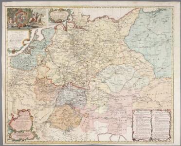
Neue und vollständige Postkarte durch ganz Deutschland und durch die angränzende Theile der benachbarten Länder / zusammen getragen und ausgefertiget von Franz Joseph Heger = Nouvelle carte geographique des postes d'Allemagne et des provinces limitrophes
1 : 1500000 titelvariant: Nouvelle carte geographique des postes d'Allemagne et des provinces limitrophes; Annotatie geografische gegevens: Legenda in het Duits en Frans Heger, Franz Joseph In Nürnberg : im Verlag bey denen Homaennischen Erben
Germania, V. Nova Tabula. [Karte], in: Claud. Ptolemaeus. Geographia lat. cum mappis [...], S. 347.
1 Karte aus Atlas Münster, Sebastian [und Ptolemaeus, Claudius]
Post- Reise-Karte von Deutschland mit spezieller Angabe der Eisenbahn- und Dampfschiffahrt-Verbindungen
1 : 1820000 Evropa střední Hagedorn, Fhr. von Löhe, Wilhelm von Piloty & Loehle
Germania, V. Nova Tabula. [Karte], in: Geographia universalis vetus et nova complectens Claudii Ptolemaei Alexandrini enarrationis libros VIII, S. 314.
1 Karte aus Atlas Münster, Sebastian [und Ptolemaeus, Claudius]
Special-Karte der Eisenbahn- Post- u[nd] Dampfschiff-Verbindungen Mittel-Europa's
1 : 1240000 Evropa střední Raab, Christian Johann Carl Koch, A. C. Flemming
Special-Karte der Eisenbahn- Post- u[nd] Dampfschiff-Verbindungen Mittel-Europa's
1 : 84000 Evropa střední Raab, Christian Johann Carl Müller, H. C. Flemming
Střední Evropa v zájmu světového míru
1 : 5000000 Evropa střední Kuffner, Hanuš
VIII. Charte für die allgemeine Geschichte von Rudolph von Habsburg bis auf Carl V : d.i. von 1273-1519 nach Christus
Entworfen von F.W. Benicken gez. von C.F. Weiland ; in Stein gravirt v. Ant. Falger Weimar : im Verlage des L. Industrie-Comptoirs
Verbreitung der wichtigsten Kulturgewächse
Evropa střední F.A. Brockhaus Geogr. artist. Anstalt
[Kaart], uit: Reise-Karte von Mittel-Europa : mit Angabe der Bahnstationen und Postverbindungen / entworfen und gezeichnet von M. Hermann
1 : 2800000 titelvariant: Reisekarte von Mittel-Europa; Annotatie: Omslagtitel: Reisekarte von Mittel-Europa Hermann, M. Glogau : Carl Flemming
Germaniae Typus. [Karte], in: Theatrum orbis terrarum, S. 159.
1 Karte aus Atlas Ortelius, Abraham Vrients, Jan Baptista
Special-Karte der Eisenbahnen Deutschlands und der angrenzenden Länder
1 : 2000000 Haeberlin, R. Ramdohr
Germaniae Veteris, typus. [Karte], in: Gerardi Mercatoris et I. Hondii Newer Atlas, oder, Grosses Weltbuch, Bd. 1, S. 135.
1 Karte aus Atlas Mercator, Gerhard und Hondius, Jodocus Jansson, Jan
Reise - Karte von Deutschland und den Nachbarstaaten

Hendschel's Post u. Reise Karte von Deutschland und den Nachbar-Staaten bis London, Paris, Montpellier, Florenz, Warschau, Kopenhagen &
Evropa střední Hendschel, U. Back, Jean Conr.
Post und Eisenbahn Reisekarte von Central Europa

Übersicht der Schnellpost und Eilwagen, ... Deutschland

Neueste Eisenbahn-Karte von Central-Europa
Evropa střední Hendschel, U. Carl Jügel
Neueste Eisenbahn-Karte von Central-Europa
1 : 1900000 Evropa střední Hendschel, U. Carl Jügel
Tabula Moderna Germanie [Karte], in: Claudii Ptolemei viri Alexandrini mathematice discipline philosophi doctissimi geographie opus [...], S. 245.
1 Karte aus Atlas Waldseemüller, Martin [und Ptolemaeus, Claudius] Übelin, Georg
Mitteleuropa Übersicht der politischen Verhältnisse und Hauptverkehrswege
1 : 5000000 Mitteleuropa Verkehrsnetz
[Deutschland, Niederlande, Belgien und Schweiz; National-, Sprach-, Dialect- Verschiedenheit]
Zweiter Band, enthaltend in vier Abtheilungen die Vertheilung der Organismen: 5. Pflanzen-Geographie, 6. Thier-Geographie, 7. Anthropographie, 8. Ethnographie Humboldt, Alexander von Verlag von Justus Perthes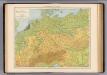
Deutschland physikalisch.
1 : 3400000 Andree, Richard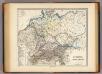
Germania, Raetia, Noricum.
1 : 3800000 Menke, Th.
Post- Reise-Karte durch Deutschland und die angraenzenden Staaten zwischen London und Lublin, Koppenhagen und Mantua
Evropa střední Schmidt, O. F. Schropp, Simon Simon Schropp & Comp.
Germaniae Veteris, typus. [Karte], in: Le théâtre du monde, ou, Nouvel atlas contenant les chartes et descriptions de tous les païs de la terre, Bd. 1, S. 320.
1 Karte aus Atlas Blaeu, Willem Janszoon und Blaeu, Joan Blaeu, Willem Janszoon

Mitteleuropa
1 : 3500000 Evropa střední Köcher
Deutschland
mapa VKOL Petermann, August Justus Perthes