Maps of Germany
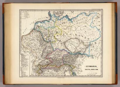
Germania, Raetia, Noricum.
1 : 3800000 Menke, Th.
Reise-Karte von Mittel-Europa : mit Angabe der Bahnstationen und Postverbindungen / nach den neuesten Quellen entw. u. gezeichnet. von M. Hermann
1 : 2800000 Annotatie: Bijlage bij: J.C. König und Erhardt's Tages-Notizbuch Hermann, M. [S.l. : s.n.] / (Glogau : Flemming)
XII. Preußen innerhalb Deutschlands mit den angrenzenden Staatengebieten
1 : 6000000 Mitteleuropa, Deutschland
Special-karte von Deutschland: nebst einem Theile der angrenzenden Länder mit Gesonderer Berücksichtigung der Gebirge und Gewässer
Fried, Franz
Post und Eisenbahn Reisekarte von Central Europa
Deutschland physikalisch.
1 : 3400000 Andree, Richard
Post- und Eisenbahn-Reisekarte von Central-Europa
1 : 2000000 Evropa střední Franz, J. Handtke, Friedrich Carl Flemming
Neueste Eisenbahn-Karte von Central-Europa
1 : 1900000 Evropa střední Hendschel, U. Carl Jügel
Deutschland
Allgemeiner Atlas [Walch, Johannes] im Verlag bei Johannes Walch
Tabula Moderna Germanie [Karte], in: Claudii Ptolemei viri Alexandrini mathematice discipline philosophi doctissimi geographie opus [...], S. 245.
1 Karte aus Atlas Waldseemüller, Martin [und Ptolemaeus, Claudius] Übelin, Georg
Mitteleuropa, Geologische Übersicht
1 : 3500000 Scobel, Albert
Střední Evropa v zájmu světového míru
1 : 5000000 Evropa střední Kuffner, Hanuš
Deutsches Reich. Niederlande, Belgien & Schweiz
Adolf Stieler's Handatlas über alle Theile der Erde und über das Weltgebäude Stieler, Adolf Justus Perthes
Special-Karte der Eisenbahnen Deutschlands und der angrenzenden Länder
1 : 2000000 Haeberlin, R. Ramdohr
Mitteleuropa
1 : 3500000 Evropa střední Köcher
Deutschland mit der Kreis-Eintheilung von 1512
Evropa střední Benecke Bormann, E. F. Tempsky
[Střední a západní Evropa]
1 : 2500000 Evropa střední
Deutschland 1555
Deutschland Kunz, Andreas ; Moeschl, Joachim Robert
Neueste Post-Karte von Deutschland und demgrösten Theil der umliegenden Staaten oder Mitter-Europa
1 : 2340000 Evropa střední Fried, Franz List, Joseph bey Artaria et Compagnie
German Empire.
1 : 2150000 Faden, William, 1750?-1836
German Empire.
1 : 2150000 Faden, William, 1750?-1836
Deutschland
E. von Sydow's Schul-Atlas in sechs und dreissig Karten Sydow, Emil von bei Justus Perthes
Telegrafenlinien, Eisenbahnen und Dampfbootfahrten in Deutschland und den Nachbarstaaten
Evropa střední Raffelsperger, Franz Franz Raffelsperger
Hendschel's Post u. Reise Karte von Deutschland und den Nachbar-Staaten bis London, Paris, Montpellier, Florenz, Warschau, Kopenhagen &
Evropa střední Hendschel, U. Back, Jean Conr.
Deutschland 1648
Deutschland Kunz, Andreas ; Moeschl, Joachim Robert
R.A. Schulz's neue praktische Reise-Karte mit Angabe der Distanzen
Evropa střední Schulz, R. A. Biller, Dominik Artaria & Co.
R.A. Schulz's neue praktische Reise-Karte mit Angabe der Distanzen
Evropa střední Schulz, R. A. Artaria & Co.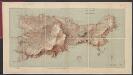
L' Empire D'Allemagne [...] [Karte], in: Atlas nouveau, contenant toutes les parties du monde [...], Bd. 1, S. 161.
1 Karte aus Atlas Sanson, Nicolas Jaillot, Alexis Hubert und Mortier, Pieter
Post- Reise-Karte durch Deutschland und die angraenzenden Staaten zwischen London und Lublin, Koppenhagen und Mantua
Evropa střední Schmidt, O. F. Schropp, Simon Simon Schropp & Comp.