Maps of Lower Saxony

II, uit: General-Karte von Mittel-Europa in 12 Blättern, im Masse 1:1.200.000 / entworfen, bearb. und hrsg. von Josef Schlacher
1 : 1200000 Annotatie: Blad 6 ontbreekt; Annotatie geografische gegevens: 21 maatstokken op blad 9; Legenda op blad 9 Wien : K.K. Militär Geografisches Institut
I. Brandenburg bis zum Tode des 1. Zollernfürsten Friedrich I. 1134 - 1440
Brandenburg Friedrich I., Brandenburg, Kurfürst
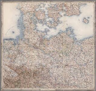
Nordwestliches Deutschland
Neuer Handatlas über alle Theile der Erde Kiepert, Heinrich Verlag von Dietrich Reimer
II. 1440 - 1608
Brandenburg Expansion
Denmark, Hanover, Brunswick, Mecklenburg, Oldenburg.
1 : 1332000 Johnston, Alexander Keith, 1804-1871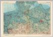
Germany - North. Pergamon World Atlas.
1 : 1250000 Polish Army Topography Service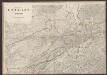
Le Cercle De La Basse Saxe subdivisé en touts, Les Estats et Principautés qui le composent. [Karte], in: Atlas nouveau, contenant toutes les parties du monde [...], Bd. 1, S. 317.
1 Karte aus Atlas Sanson, Nicolas Jaillot, Alexis Hubert und Mortier, Pieter
[Das Deutsches Reich, Blatt 1]
Adolf Stieler's Handatlas über alle Theile der Erde und über das Weltgebäude Stieler, Adolf Justus Perthes
Denmark with Northwest portion of the German Empire
1 : 1332000 Johnston, W. & A.K.
Daniae Regni Typus. [Karte], in: Theatrum orbis terrarum, S. 204.
1 Karte aus Atlas Ortelius, Abraham Vrients, Jan Baptista
Allemagne du N.O.
1 : 1500000 Vivien St Martin, L.
Denmark with Northwest portion of the German Empire
1 : 1332000 Johnston, Alexander Keith
Nord-Östliches Deutschland
Handatlas über alle Theile der Erde und über das Weltgebäude Stieler, Adolf Justus Perthes
Nord-Östliches Deutschland
Hand-Atlas über alle Theile der Erde und über das Weltgebäude Stieler, Adolf Justus Perthes
Nordwestl. Deutschland und Daenemark
[Allgemeiner Atlas über alle Theile der Erde in 29 Blättern] Ziegler, Jakob Melchior Top. Anstalt v. J. Wurster u. Comp.
Denmark with Northwest portion of the German Empire
1 : 1332000 Johnston, Alexander Keith
Northern and Central Germany.
1 : 2154240 Fullarton, A. & Co.
Germany north.
1 : 2800000 Arrowsmith, Aaron; Lewis, Samuel
Germany north.
1 : 2800000 Arrowsmith, Aaron; Lewis, Samuel
Germany No.2.
1 : 1375000 Colton, G.W.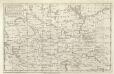
A Map of the Seat of War in Germany &c.
Mollova mapová sbírka Bennett Dilly, Charles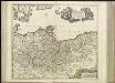
[40][40] Marchionatus Brandenburgi et Ducatus Pomeraniae tabula..., uit: Atlas sive Descriptio terrarum orbis
Annotatie: Gedigitaliseerde versie. Amsterdam. Heiloo : Picturae (vervaardiger), 2015. tiff-bestand. Gedigitaliseerd: 07-01-2015; Origineel: Universiteitsbibliotheek Vrije Universiteit (XL.05127.-) ; Netherlands; Titelpagina ontbreekt Wit, Frederik de Amsterdam : Frederick de Wit
Niedersächsischer Kreis
Allgemeiner Atlas [Walch, Johannes] im Verlag bei Johannes Walch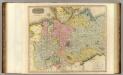
Germany N. of Mayne.
1 : 1200000 Thomson, John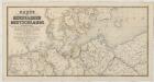
Karte der Eisenbahnen Deutschlands
1 : 700000 Nordwest-Blatt Stich, Druck u. Verlag des lithographischen Instituts von Aug. Wehrt
Germany. Deutschland I.
1 : 1760000 Society for the Diffusion of Useful Knowledge (Great Britain)
Königreich Westphalen samt dem Herzogthume Mecklenburg
1 : 2230000 Meklenbursko (Německo)