Maps of Mecklenburg-Vorpommern

Karte der Eisenbahnen Deutschlands
1 : 700000 Nordwest-Blatt Stich, Druck u. Verlag des lithographischen Instituts von Aug. Wehrt
Leuchtfeuer an den deutschen Küsten
1 : 2000000 Německo Meyer, Joseph Bibliographisches Institut
[40][40] Marchionatus Brandenburgi et Ducatus Pomeraniae tabula..., uit: Atlas sive Descriptio terrarum orbis
Annotatie: Gedigitaliseerde versie. Amsterdam. Heiloo : Picturae (vervaardiger), 2015. tiff-bestand. Gedigitaliseerd: 07-01-2015; Origineel: Universiteitsbibliotheek Vrije Universiteit (XL.05127.-) ; Netherlands; Titelpagina ontbreekt Wit, Frederik de Amsterdam : Frederick de Wit
II, uit: General-Karte von Mittel-Europa in 12 Blättern, im Masse 1:1.200.000 / entworfen, bearb. und hrsg. von Josef Schlacher
1 : 1200000 Annotatie: Blad 6 ontbreekt; Annotatie geografische gegevens: 21 maatstokken op blad 9; Legenda op blad 9 Wien : K.K. Militär Geografisches Institut
[Das Deutsches Reich, Blatt 1]
Adolf Stieler's Handatlas über alle Theile der Erde und über das Weltgebäude Stieler, Adolf Justus Perthes
[Königreich Daenemark]
Neuester Schul-Atlas Walch, Johann im Verlag bei Joh. Walch
Atlas für Handel und Industrie: Für Kaufleute, Fabrikante u. Gewerbetreibende, Handlungs- u. Gewerbe-Schulen

Daenemark
Allgemeiner Atlas [Walch, Johannes] im Verlag bei Johannes Walch

Nordwestliches Deutschland
Neuer Handatlas über alle Theile der Erde Kiepert, Heinrich Verlag von Dietrich Reimer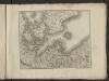
Théatre de la guerre actuelle, en Allemagne, en Pologne et en Turquie. n3 (bis)
1 : 900000 Chanlaire, Pierre Grégoire 1758-1817 Paris : chez l'auteur P. G. Chanlaire
Regnum Daniae, divisum in Dioeceses Arhusiam, Albergum, Viborgum et Ripam, Insulas Zelandiam, Fioniam, Lalandiam, Falstriam, Monam, Langelandiam, Arram, Samsoam, Amagam, Soltholmiam et Bornholmiam, et partem in Ducatibus Slesvico et Holsatia
1 : 750000 per Gerardo et Leonardo Valk [Amsterdam], Gerardo et Leonardo Valk
Das Königreich Daenemark nebst seinen Nebenlaendern in Europa
1 : 1100000 entworfen und gezeichnet von C.F. Weiland Weimar : Verlag des Geographischen Instituts
[Daenemark mit Holstein u. Lauenburg]
Stieler's Hand-Atlas Stieler, Adolf bei Justus Perthes
Daenemark mit Holstein und Lauenburg auch südlicher Theil von Schweden
1 : 3200000 Dánsko
Denmark, Holstein, Mecklenburg, Island.
1 : 2000000 Meyer, Joseph, 1796-1856
[Daenemark mit Holstein und Lauenburg; auch Island und Fär-Öer]
Schul-Atlas über alle Theile der Erde nach dem neuesten Zustande, und über das Weltgebäude Stieler, Adolf bei Justus Perthes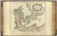
Danemarck.
1 : 1180000 Robert de Vaugondy, Gilles, 1688-1766
[64][64] Dania Regnum ..., uit: Atlas sive Descriptio terrarum orbis
Annotatie: Gedigitaliseerde versie. Amsterdam. Heiloo : Picturae (vervaardiger), 2015. tiff-bestand. Gedigitaliseerd: 07-01-2015; Origineel: Universiteitsbibliotheek Vrije Universiteit (XL.05127.-) ; Netherlands; Titelpagina ontbreekt Wit, Frederik de Amsterdam : Frederick de Wit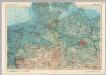
Germany - North. Pergamon World Atlas.
1 : 1250000 Polish Army Topography Service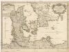
Le royaume de Danemark
1 : 1200000 Dánsko Sanson, Guillaume Cordier, Louis chez H. Iaillot
Daenemark
E. von Sydow's Schul-Atlas in sechs und dreissig Karten Sydow, Emil von bei Justus Perthes
Regni Daniæ : novissima et accuratissima tabula / per Nicolaum Visscher
1 : 1150000 Annotatie: Origineel is Blad 144 in atlas factice; Annotatie geografische gegevens: Met schaalstok: Milliaria Germanica communia Nicolaes Jansz. Visscher jr. 1649-1702 [Amsterdam] : [Nicolaes Visscher]
Das Königreich Daenemark
1 : 1090000 Dánsko Weiland, Karl Ferdinand Geographisches Institut
Regni Daniae, Novißima et Accuratißima Tabula [Karte], in: Novus atlas absolutissimus, Bd. 1, S. 119.
1 Karte aus Atlas Janssonius Offizin
Danemark.
1 : 2250000 Malte-Brun, Conrad, 1775-1826
Daniae Regnum [Karte], in: Gerardi Mercatoris Atlas, sive, Cosmographicae meditationes de fabrica mundi et fabricati figura, S. 140.
1 Karte aus Atlas Mercator, Gerhard Montanus, Petrus
Marchionatus Brandenburgi et ducatus Pomeraniae tabula quae est pars Septentrionalis circuli Saxoniae Superioris / authore F. de Wit Amstelodami
1 : 1000000 Annotatie: Origineel is Blad 90 in atlas factice; Annotatie geografische gegevens: Met 3 schaalstokken Frederick de Wit 1630-1706 Amstelodami : F. de Wit
Tabula Marchionatus Brandenburgici Et Ducatus Pomeraniae
1 : 1000000 Mollova mapová sbírka Homann, Johann Baptist Homann, Johann Baptista - dědici


