Maps of Denmark
Danemarck.
1 : 1180000 Robert de Vaugondy, Gilles, 1688-1766
[Daenemark mit Holstein u. Lauenburg]
Stieler's Hand-Atlas Stieler, Adolf bei Justus Perthes
Dania Regnum [Karte], in: Theatrum orbis terrarum, sive, Atlas novus, Bd. 1, S. 47.
1 Karte aus Atlas Blaeu, Joan Blaeu, Willem Janszoon
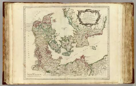
Le royaume de Danemark
1 : 1200000 Dánsko Sanson, Guillaume Cordier, Louis chez H. Iaillot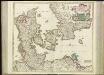
[64][64] Dania Regnum ..., uit: Atlas sive Descriptio terrarum orbis
Annotatie: Gedigitaliseerde versie. Amsterdam. Heiloo : Picturae (vervaardiger), 2015. tiff-bestand. Gedigitaliseerd: 07-01-2015; Origineel: Universiteitsbibliotheek Vrije Universiteit (XL.05127.-) ; Netherlands; Titelpagina ontbreekt Wit, Frederik de Amsterdam : Frederick de Wit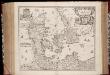
Regni Daniæ : novissima et accuratissima tabula / per Nicolaum Visscher
1 : 1150000 Annotatie: Origineel is Blad 144 in atlas factice; Annotatie geografische gegevens: Met schaalstok: Milliaria Germanica communia Nicolaes Jansz. Visscher jr. 1649-1702 [Amsterdam] : [Nicolaes Visscher]
Regni Daniae, Novißima et Accuratißima Tabula [Karte], in: Novus atlas absolutissimus, Bd. 1, S. 119.
1 Karte aus Atlas Janssonius Offizin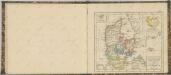

[Dänemark, Island, die Far-Oer]
Plastischer Schul-Atlas über alle Theile der Erde : in 24 Karten Woldermann, G Verlag von P. Eckerlein
Dania Regnum [Karte], in: Novus Atlas, das ist, Weltbeschreibung, Bd. 1, S. 33.
1 Karte aus Atlas Blaeu, Joan Blaeu, Willem Janszoon
Regni Daniae Accuratissima delineatio. [Karte], in: Novus atlas absolutissimus, Bd. 1, S. 116.
1 Karte aus Atlas Janssonius Offizin
DANIA | REGNVM.
[Amsterdam : Joan Blaeu]
Dania Regnum [Karte], in: Le théâtre du monde, ou, Nouvel atlas contenant les chartes et descriptions de tous les païs de la terre, Bd. 1, S. 49.
1 Karte aus Atlas Blaeu, Willem Janszoon und Blaeu, Joan Blaeu, Willem Janszoon
Das Königreich Daenemark
1 : 1090000 Dánsko Weiland, Karl Ferdinand Geographisches Institut
Das Königreich Daenemark nebst seinen Nebenlaendern in Europa
1 : 1100000 entworfen und gezeichnet von C.F. Weiland Weimar : Verlag des Geographischen Instituts
Regni Daniae accuratissima delineatio
1 : 1150000 Dánsko Wit, Frederick de Frederick de Witt
Regni Daniae
1 : 1129000 Dánsko Visscher, Nicolaus per Nicolaum Visscher
REGNI DANIAE, Novißima et accuratißima TABULA
1 : 1130000 Dánsko Visscher, Nicolaus per Nicolaum Visscher
Regni Daniae in quo sunt ducatus Holsatia et Slesvicum insulae Danicae provinciae Iutia Scania Blekingia nova tabula
1 : 1100000 Dánsko Homann, Johann Baptist
Regni Daniae, in quo sunt ducatus Holsatia et Slesvicum, insulae Danicae, provinciae Iutia Scania Blekingia etc. nova tabula
1 : 1100000 Dánsko Homann, Johann Baptist â Io. Baptista Homanno
Regni Daniae, in quo sunt ducatus Holsatia et Slesvicum, insulae Danicae, provinciae Iutia Scania Blekingia etc. nova tabula
1 : 1100000 Dánsko Homann, Johann Baptist â Io. Baptista Homanno
REGNI DANIAE, in quo sunt DUCATUS HOLSATIA ET SLESVICUM, INSULAE DANICAE, PROVINCIA IUTIA SCANIA BLEKINGIA &c. Nova Tabula
1 : 1100000 Dánsko Homann, Johann Baptist a Io. Baptista Homanno
Atlas für Handel und Industrie: Für Kaufleute, Fabrikante u. Gewerbetreibende, Handlungs- u. Gewerbe-Schulen

Das Königreich Daenemark
1 : 1090000 Dánsko Weiland, Karl Ferdinand Geographischen Institut
Das Königreich Daenemark
1 : 1090000 Dánsko Weiland, Karl Ferdinand Maedel, A. Geograph. Institut
Königreich Daenemark
1 : 2530000 Dánsko
Generalkarte des Königreichs Daenemark
1 : 860000 Dánsko Sotzmann, Daniel Friedrich Kunsthandlung Ad. Gott. Schneider und Weigels
Daniae Regni Typus. [Karte], in: Theatrum orbis terrarum, S. 56.
1 Karte aus Atlas Ortelius, Abraham