Maps of Denmark

Denmark, Holstein, Mecklenburg, Island.
1 : 2000000 Meyer, Joseph, 1796-1856
[Neueste Karte von Dänemark mit Holstein und Lauenburg, Mecklenburg Schwerin Strelitz, Oldenburg, die freien Städte Hamburg, Lübeck und Bremen]
Grosser Hand-Atlas über alle Theile der Erde in 170 Karten Meyer, J. Verlag des Bibliographischen Instituts
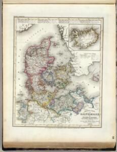
Danemark.
1 : 2250000 Malte-Brun, Conrad, 1775-1826
Denmark, Hanover, Brunswick, Mecklenburg, Oldenburg.
1 : 1332000 Johnston, Alexander Keith, 1804-1871
Daenemark, Island, die Far-Oer und die Herzogthümer Schleswig, Holstein & Lauenburg
1 : 860000 Dánsko Gräf, Carl Haubold, Georg Geographisches Institut
Daenemark, Island, die Far-Oer und die Herzogthümer Schleswig, Holstein & Lauenburg
1 : 800000 Dánsko Gräf, C. Haubold, G. Geographisches Institut
[Dänemark und die Dänischen Kolonien]
Handatlas über alle Theile der Erde und über das Weltgebäude Stieler, Adolf Justus Perthes
Danemark, Schleswig, Holstein, Lauenburg.
1 : 1500000 Flemming, Carl
Daenemark
Schul-Atlas in 36 Karten Völter, Daniel Verlag der J.M. Dannheimer'schen Buchhandlung
Daenemark, Island.
1 : 875000 Weiland, C. F. (Carl Ferdinand), d. 1847
Dänemark, Schleswig, Holstein u. Lauenburg, nebst den Dänischen Colonien
Hand-Atlas über alle Theile der Erde und über das Weltgebäude Stieler, Adolf Justus Perthes
[Königreich Daenemark]
Neuester Schul-Atlas Walch, Johann im Verlag bei Joh. Walch
Daenemark.
1 : 1900000 Reichard, C. G.
Daniae Regni Typus. [Karte], in: Theatrum orbis terrarum, S. 204.
1 Karte aus Atlas Ortelius, Abraham Vrients, Jan Baptista

[Neuer Atlas der ganzen Erde nach den neuesten Bestimmungen ... : XIII.] Der Daenische Staat und die Gebiete der freien Städte Hamburg und Lübeck
Entworfen und gezeichnet von Dr. F.W. Streit H. Leutemann sc. Leipzig : J.C. Hinrichs'sche Buchhandlung

Daniae regnum cum ducatu Holsatiae et Slesvici nec non insulae Danicae et Iutia cum parte Scaniae
1 : 941000 Dánsko Lotter, Tobias Conrad studio Tobiae Conradi Lotteri
Daenemark, Schleswig, Holstein, Lauenburg, Island, Faer-Oer.
1 : 5400000 Brudin, J. L.; Stieler, Adolf
Denmark with Northwest portion of the German Empire
1 : 1332000 Johnston, W. & A.K.
Daniae Reg. cum Ducatu Holsatiae et Slesvici
1 : 500000 Weyerman, Jacob Campo
Denmark.
1 : 2400000 Bowen, Emanuel
Denmark with Northwest portion of the German Empire
1 : 1332000 Johnston, Alexander Keith
[64][64] Dania Regnum ..., uit: Atlas sive Descriptio terrarum orbis
Annotatie: Gedigitaliseerde versie. Amsterdam. Heiloo : Picturae (vervaardiger), 2015. tiff-bestand. Gedigitaliseerd: 07-01-2015; Origineel: Universiteitsbibliotheek Vrije Universiteit (XL.05127.-) ; Netherlands; Titelpagina ontbreekt Wit, Frederik de Amsterdam : Frederick de Wit
Regni Daniae Novißima et Accuratißima Tabula
1 : 1100000 Mollova mapová sbírka Visscher, Nicolaes Visscher, Nicolaus
Atlas für Handel und Industrie: Für Kaufleute, Fabrikante u. Gewerbetreibende, Handlungs- u. Gewerbe-Schulen

[DANIA REGNUM in quo sunt ducatus HOLSATIA et SLESVICUM INSULAE DANICAE et PROVINCIAE IUTIA, SCANIA, BLEKINGIA ET HALLANDIA]
1 : 1050000 Dánsko Wit, Frederick de F. de Wit
Denmark with Northwest portion of the German Empire
1 : 1332000 Johnston, Alexander Keith
Charte des Königreichs Daenemark, nach Murdochischer Projection und nach den trigonometrischen Charten der König
1 : 919000
Daenemarck.
Dánsko Güssefeld, Franz L. Mollo, Tranquillo Tranquillo Mollo
Daenemarck
1 : 1260000 Bornholm (Dánsko) Mollo, Tranquillo Tranquillo Mollo
Daenemarck
1 : 1245000 Dánsko Tranquillo Mollo