Maps of Brandenburg

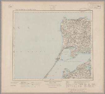
17. Pillau, uit: Topographische Uebersichtskarte des Deutschen Reiches / herausgegeben v. d. Kartogr. Abt. d. Königl. Preuß. Landesaufnahme
1 : 200000 titelvariant: Topogr. Übersichtskarte des Deutschen Reiches; Annotatie: Titel boven bladen ook: Topogr. Übersichtskarte des Deutschen Reiches; Annotatie geografische gegevens: Op elk blad twee maatstokken: 10 Kilometer = 5,5 cm; 1 geogr. Meile = 3,6 cm; Legenda onder op elk blad Königlich Preußische Landesaufnahme. Kartographische Abtheilung [S.l : Königlich Preußische Landesaufnahme, Kartographische Abtheilung]

II, uit: General-Karte von Mittel-Europa in 12 Blättern, im Masse 1:1.200.000 / entworfen, bearb. und hrsg. von Josef Schlacher
1 : 1200000 Annotatie: Blad 6 ontbreekt; Annotatie geografische gegevens: 21 maatstokken op blad 9; Legenda op blad 9 Wien : K.K. Militär Geografisches Institut
85. German Democratic Republic (East Germany). The World Atlas.
1 : 1250000 USSR (Union of Soviet Socialist Republics).
Bezirke der DDR 1952
Deutschland, DDR Kunz, Andreas ; Moeschl, Joachim Robert
Länder der DDR 3.10.1990
Deutschland, DDR Kunz, Andreas ; Moeschl, Joachim Robert
Länder der DDR 1949
Deutschland, DDR Kunz, Andreas ; Moeschl, Joachim Robert
German Democratic Republic. Pergamon World Atlas.
Polish Army Topography Service
Prehľadná automapa NDR

Nordwestliches Deutschland
Neuer Handatlas über alle Theile der Erde Kiepert, Heinrich Verlag von Dietrich Reimer
Electoratus Brandenburgi, Mekelenburgi, Et maximae Partis Pomeraniae novissima Tabula. [Karte], in: Novus atlas absolutissimus, Bd. 2, S. 54.
1 Karte aus Atlas Janssonius Offizin
A map of Upper Saxony comprehending that part of Germany which is the present seat of war
1 : 2534400
[Die Provinzen Brandenburg, Pommern und Sachsen, nebst Anhalt und Mecklenburg]
Schul-Atlas in 36 Karten Völter, Daniel Verlag der J.M. Dannheimer'schen Buchhandlung
Brandeburgum Marchionatus, cum Ducatibus Pomeraniae et Mekelenburgi. [Karte], in: Novus Atlas, das ist, Weltbeschreibung, Bd. 1, S. 99.
1 Karte aus Atlas Blaeu, Joan Blaeu, Willem Janszoon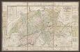
Tabula Electoratus Brandenburgici, Meckelenburgi, Et Maximae Partis Pomeraniae [...] [Karte], in: Gerardi Mercatoris et I. Hondii Newer Atlas, oder, Grosses Weltbuch, Bd. 1, S. 319.
1 Karte aus Atlas Mercator, Gerhard und Hondius, Jodocus Jansson, Jan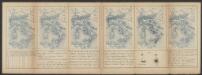
Brandeburgum Marchionatus, cum Ducatibus Pomeraniae et Mekelenburgi. [Karte], in: Le théâtre du monde, ou, Nouvel atlas contenant les chartes et descriptions de tous les païs de la terre, Bd. 1, S. 128.
1 Karte aus Atlas Blaeu, Willem Janszoon und Blaeu, Joan Blaeu, Willem Janszoon
Marchionatus Brandenburgi et ducatus Pomeraniae tabula quae est pars Septentrionalis circuli Saxoniae Superioris / authore F. de Wit Amstelodami
1 : 1000000 Annotatie: Origineel is Blad 90 in atlas factice; Annotatie geografische gegevens: Met 3 schaalstokken Frederick de Wit 1630-1706 Amstelodami : F. de Wit
Brandeburgum Marchionatus, cum Ducatibus Pomeraniae et Mekelenburgi. [Karte], in: Theatrum orbis terrarum, sive, Atlas novus, Bd. 1, S. 161.
1 Karte aus Atlas Blaeu, Joan Blaeu, Willem Janszoon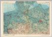
Germany - North. Pergamon World Atlas.
1 : 1250000 Polish Army Topography Service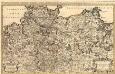
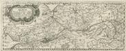
Le Cercle de la Basse Saxe
1 : 770000 Mollova mapová sbírka Sanson, Guillaume Jaillot, Alexis Hubert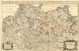
Le Cercle de la Basse Saxe
1 : 770000 Mollova mapová sbírka Sanson, Guillaume Jaillot, Alexis Hubert
Karte der Mark Brandenburg und des Herzogthums Pommern
Neuester Schul-Atlas Walch, Johann im Verlag bei Joh. Walch
Le Cercle De La Basse Saxe subdivisé en touts, Les Estats et Principautés qui le composent. [Karte], in: Atlas nouveau, contenant toutes les parties du monde [...], Bd. 1, S. 317.
1 Karte aus Atlas Sanson, Nicolas Jaillot, Alexis Hubert und Mortier, Pieter
Albis Fluvius Germaniae celebris A Fontibus ad Ostia
1 : 880000 Mollova mapová sbírka Ottens, Joachim Ottens, Joachim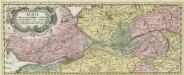
Albis Fluvius Germaniae celebris A Fontibus ad Ostia
1 : 880000 Mollova mapová sbírka Ottens, Joachim Ottens, Joachim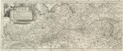
Eigentliche Vorstellung dess grossen Elb-Stroms in Deutschland, vom Ursprung biss zu seinen Ausfluss, mit seinen beyderseits einfliessenden Wassern und Flüssen
1 : 880000 Mollova mapová sbírka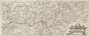
Eigentliche Vorstellung dess grossen Elb-Stroms in Deutschland, vom Ursprung biss zu seinen Ausfluss, mit seinen beyderseits einfliessenden Wassern und Flüssen
1 : 880000 Mollova mapová sbírka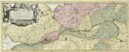
Albis Fluvius Germaniae celebris A Fontibus ad Ostia
1 : 860000 Mollova mapová sbírka Aveele, Johannes van den Schenk, Peter I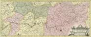
Albis Fluvius Germaniae celebris A Fontibus ad Ostia
1 : 860000 Mollova mapová sbírka Aveele, Johannes van den Schenk, Peter I