Maps of Lower Saxony

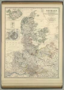
Denmark with Northwest portion of the German Empire
1 : 1332000 Johnston, Alexander Keith
Denmark with Northwest portion of the German Empire
1 : 1332000 Johnston, Alexander Keith
Denmark with Northwest portion of the German Empire
1 : 1332000 Johnston, W. & A.K.
Denmark, Hanover, Brunswick, Mecklenburg, Oldenburg.
1 : 1332000 Johnston, Alexander Keith, 1804-1871
Daniæ, Frisiæ, Groningæ et Orientalis Frisiæ littora
1 Karte : Kupferdruck ; 48 x 56 cm Renard apud L. Renard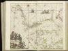
[124][127] Daniae, Frisiae, Groningae et Orientalis Frisiae littora, uit: Atlas sive Descriptio terrarum orbis
Annotatie: Gedigitaliseerde versie. Amsterdam. Heiloo : Picturae (vervaardiger), 2015. tiff-bestand. Gedigitaliseerd: 07-01-2015; Origineel: Universiteitsbibliotheek Vrije Universiteit (XL.05127.-) ; Netherlands; Titelpagina ontbreekt Wit, Frederik de Amsterdam : Frederick de Wit
Danemark vizt Jutland, Zeland, Sleswick, Holstein.
from A new systeme of the mathematicks: containing I. Arithmetick, as well natural and decimal, as in species, or the principles of algebra. II. Practical geometry, together with the first six books of Euclid's Elements, as also the eleventh and twelfth, symbo
[Königreich Daenemark]
Neuester Schul-Atlas Walch, Johann im Verlag bei Joh. Walch
Nordwestl. Deutschland und Daenemark
[Allgemeiner Atlas über alle Theile der Erde in 29 Blättern] Ziegler, Jakob Melchior Top. Anstalt v. J. Wurster u. Comp.
Daenemark
Allgemeiner Atlas [Walch, Johannes] im Verlag bei Johannes Walch
Daniae Regni Typus. [Karte], in: Theatrum orbis terrarum, S. 204.
1 Karte aus Atlas Ortelius, Abraham Vrients, Jan Baptista
Daenemark mit Holstein und Lauenburg auch südlicher Theil von Schweden
1 : 3200000 Dánsko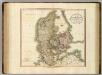
Denmark.
1 : 1100000 Cary, John, ca. 1754-1835
Daenemarck.
Dánsko Güssefeld, Franz L. Mollo, Tranquillo Tranquillo Mollo
Daenemarck
1 : 1260000 Bornholm (Dánsko) Mollo, Tranquillo Tranquillo Mollo
Daenemarck
1 : 1245000 Dánsko Tranquillo Mollo
Daenemarck.
Dánsko Güssefeld, Franz L. Mollo, Tranquillo Tranquillo Mollo
Daenemark
E. von Sydow's Schul-Atlas in sechs und dreissig Karten Sydow, Emil von bei Justus Perthes
Denmark, Holstein, Mecklenburg, Island.
1 : 2000000 Meyer, Joseph, 1796-1856
[Das Deutsches Reich, Blatt 1]
Adolf Stieler's Handatlas über alle Theile der Erde und über das Weltgebäude Stieler, Adolf Justus Perthes
[Neueste Karte von Dänemark mit Holstein und Lauenburg, Mecklenburg Schwerin Strelitz, Oldenburg, die freien Städte Hamburg, Lübeck und Bremen]
Grosser Hand-Atlas über alle Theile der Erde in 170 Karten Meyer, J. Verlag des Bibliographischen Instituts
Atlas für Handel und Industrie: Für Kaufleute, Fabrikante u. Gewerbetreibende, Handlungs- u. Gewerbe-Schulen

[Daenemark mit Holstein und Lauenburg; auch Island und Fär-Öer]
Schul-Atlas über alle Theile der Erde nach dem neuesten Zustande, und über das Weltgebäude Stieler, Adolf bei Justus Perthes
Denmark.
1 : 1250000 Teesdale, Henry
Denmark, Sleswig, Holstein.
1 : 823680 Stanford, Edward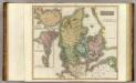
Denmark, Iceland, Feroe Islands.
1 : 960000 Thomson, John
[Daenemark mit Schleswig, Holstein und Lauenburg auch Südl. Theil v. Schweden]
Hand-Atlas über alle Theile der Erde nach dem neuesten Zustande und über das Weltgebäude Stieler, Adolf bei Justus Perthes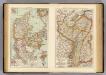
Denmark, Alsace-Lorraine, Palatinate.
1 : 1500000 Andree, Richard; Times (London, England)
Denmark.
1 : 1800000 Mitchell, Samuel Augustus