Maps of Germany

[Geologische Karte von Deutschland und den anlieg. Ländern]
Erster Band, enthaltend in vier Abtheilungen die Erscheinungen der anorganischen Natur: 1. Meteorologie und Klimatographie. 2. Hydrologie und Hydrographie. 3. Geologie. 4. Tellurischer Magnetismus Humboldt, Alexander von Verlag von Justus Perthes
[Fluss- u. Berg-Karte von Deutschland und den anlieg. Ländern]
Hand-Atlas über alle Theile der Erde nach dem neuesten Zustande und über das Weltgebäude Stieler, Adolf bei Justus Perthes
Fluss- und Bergkarte von Deutschland und den anliegenden Ländern
Handatlas über alle Theile der Erde und über das Weltgebäude Stieler, Adolf Justus Perthes
[Fluss- u. Berg-Karte von Deutschland und den anlieg. Ländern]
Hand-Atlas über alle Theile der Erde nach dem neuesten Zustande und über das Weltgebäude Stieler, Adolf bei Justus Perthes

[Fluss- u. Berg-Karte von Deutschland und den anlieg. Ländern]
Stieler's Hand-Atlas Stieler, Adolf bei Justus Perthes
Fluss und Bergkarte von Deutschland und den anliegenden Ländern
Hand-Atlas über alle Theile der Erde und über das Weltgebäude Stieler, Adolf Justus Perthes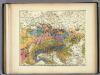
Geologische Karte von Deutschland und den anlieg.
1 : 4600000 Berghaus, Heinrich
Geologische Karte von Deutschland und anlieg. Ländern

Fluss Und Bergkarte Von Deutschland Und Den Anliegenden Landern.
1 : 4625000 Berghaus, Hermann
Post- Reise-Karte durch Deutschland und die angraenzenden Staaten zwischen London und Lublin, Koppenhagen und Mantua
Evropa střední Schmidt, O. F. Schropp, Simon Simon Schropp & Comp.
Deutschland
mapa VKOL Petermann, August Justus Perthes
Deutschland
mapa VKOL Petermann, August Justus Perthes
Neueste Eisenbahn-Karte von Central-Europa
1 : 1900000 Evropa střední Hendschel, U. Carl Jügel
Mitteleuropa am Ende des 30 jährigen Krieges
Evropa střední F. Tempsky
Hendschel's Post u. Reise Karte von Deutschland und den Nachbar-Staaten bis London, Paris, Montpellier, Florenz, Warschau, Kopenhagen &
Evropa střední Hendschel, U. Back, Jean Conr.
Mitteleuropa
1 : 3500000 Evropa střední Köcher
Mitteleuropa während des 30 jährigen Krieges.
Evropa střední Benecke Bormann, E. F. Tempsky
Deutschland
Allgemeiner Atlas [Walch, Johannes] im Verlag bei Johannes Walch
Fluss- und Gebirgs-Karte von Mittel-Eüropa
1 : 4900000 Evropa střední Handtke, Friedrich C. Flemming
Karte der Eisenbahnen Mittel - Europa ́s ...
VIII. Charte für die allgemeine Geschichte von Rudolph von Habsburg bis auf Carl V : d.i. von 1273-1519 nach Christus
Entworfen von F.W. Benicken gez. von C.F. Weiland ; in Stein gravirt v. Ant. Falger Weimar : im Verlage des L. Industrie-Comptoirs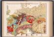
Mitteleuropa, Geologische Übersicht
1 : 3500000 Scobel, Albert
Eisenbahn-Routen-Karte von Mittel-Europa
Evropa střední Ritter, Julius R. v. Waldheim
Sbírka map a diagramů použitých na mírových konferencích v Paříži v letech 1919 - 1920

Germania Augustiniana
1 : 2600000 Mollova mapová sbírka Seutter, Matthäus Seutter, Matthäus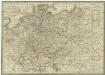
Neueste Post-Karte von Deutschland und dem grösten Theil der umliegenden Staaten oder Mittel-Europa
1 : 2350000 Evropa střední Fried, Franz List, C. Artaria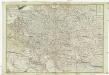
Neue und vollkomene Postkarte durch ganz Teutschland
1 : 2100000 Evropa jihovýchodní bey Artaria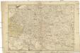
Neue und vollkomene Postkarte durch ganz Teutschland
1 : 2100000 Evropa jihovýchodní Artaria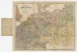
![[Geologische Karte von Deutschland und den anlieg. Ländern]](https://images-2.georeferencer.com/images/iiif/902768191784/full/,300/0/native.jpg)

