Maps of Germany
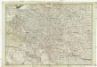
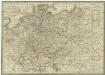
Neue und vollkomene Postkarte durch ganz Teutschland
1 : 2100000 Evropa jihovýchodní bey Artaria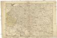
Neue und vollkomene Postkarte durch ganz Teutschland
1 : 2100000 Evropa jihovýchodní Artaria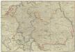
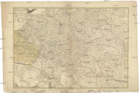
Postkarte durch ganz Teutschland, Italien, Frankreich, Niederland, Preussen, Polen und Ungarn
1 : 2100000 Evropa střední Mollo, Tranquillo T. Mollo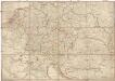
Postkarte durch ganz Teutschland, Italien, Frankreich, Niederland, Preussen, Polen und Ungarn
1 : 2100000 Evropa střední Mollo, Tranquillo T. Mollo & Comp.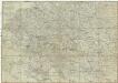
Postkarte durch ganz Teutschland, Italien, Frankreich, Niederland, Preussen, Polen und Ungarn
1 : 2100000 Evropa jihovýchodní Mollo, Tranquillo chez T. Mollo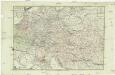
Neue und vollkomene Postkarte durch ganz Deutschland
Florencie (Itálie) Mansfeld, Johann Ernst Artaria & Co.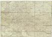
Neue und vollkomene Postkarte durch ganz Teutschland
Francie Artaria
Fluss Und Bergkarte Von Deutschland Und Den Anliegenden Landern.
1 : 4625000 Berghaus, Hermann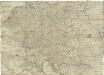
Postkarte durch ganz Deutschland, Italien, Frankreich, Niederland, Preussen, Polen und Ungarn
Florencie (Itálie) Mollo, Tranquillo T. Mollo
Mitteleuropa
1 : 3500000 Evropa střední Köcher
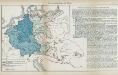
Sbírka map a diagramů použitých na mírových konferencích v Paříži v letech 1919 - 1920

Österreich
1 : 7500000 Rakousko F. Tempsky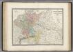
Allemagne en 1789.
1 : 3580000 Levasseur, E.
[Fluss- u. Berg-Karte von Deutschland und den anlieg. Ländern]
Stieler's Hand-Atlas Stieler, Adolf bei Justus Perthes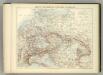
Carte Politique de L'Europe Centrale.
1 : 3600000 Jouvet et Cie.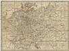
Neueste Post-Karte von Deutschland und demgrösten Theil der umliegenden Staaten oder Mitter-Europa
1 : 2340000 Evropa střední Fried, Franz List, Joseph bey Artaria et Compagnie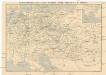
Eisenbahn-Routen-Karte von Mittel-Europa
Evropa střední Ritter, Julius R. v. Waldheim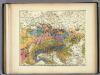
Geologische Karte von Deutschland und den anlieg.
1 : 4600000 Berghaus, Heinrich
Mitteleuropa am Ende des 30 jährigen Krieges
Evropa střední F. Tempsky
Mitteleuropa während des 30 jährigen Krieges.
Evropa střední Benecke Bormann, E. F. Tempsky
Habsburger Monarchie 1648 nach dem Westfälischen Frieden
Österreich Westfälischer Friedenskongress Kunz, Andreas ; Moeschl, Joachim Robert
Geologische Karte von Deutschland und anlieg. Ländern
Nr. 8a. Die Germanisierung des Ostens
Ostmitteleuropa Deutsche, Siedlung
Fluss und Bergkarte von Deutschland und den anliegenden Ländern
Hand-Atlas über alle Theile der Erde und über das Weltgebäude Stieler, Adolf Justus Perthes

[Geologische Karte von Deutschland und den anlieg. Ländern]
Erster Band, enthaltend in vier Abtheilungen die Erscheinungen der anorganischen Natur: 1. Meteorologie und Klimatographie. 2. Hydrologie und Hydrographie. 3. Geologie. 4. Tellurischer Magnetismus Humboldt, Alexander von Verlag von Justus Perthes
Neueste Karte vom Deutschen Reich der Oesterreichisch-Ungarischen Monarchie, der Schweiz, den Niederlanden, Belgien, Rumänien, nebst Theilen der angrenzenden Länder.mit besonderer Rücksicht auf Handel & Verkehrs-Interessen sowie zum Hand- und Comptoir-Gebrauch
mapa VKOL Baur, Carl Friedrich A. Hartleben's Verlag
[Fluss- u. Berg-Karte von Deutschland und den anlieg. Ländern]
Hand-Atlas über alle Theile der Erde nach dem neuesten Zustande und über das Weltgebäude Stieler, Adolf bei Justus Perthes
Composite Map: Map of the Central States of Europe Situate between France and Russia
1 : 1200000 Faden, William (1749-1836)