Maps of Germany

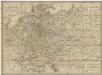
[Fluss- u. Berg-Karte von Deutschland und den anlieg. Ländern]
Stieler's Hand-Atlas Stieler, Adolf bei Justus Perthes

[Geologische Karte von Deutschland und den anlieg. Ländern]
Erster Band, enthaltend in vier Abtheilungen die Erscheinungen der anorganischen Natur: 1. Meteorologie und Klimatographie. 2. Hydrologie und Hydrographie. 3. Geologie. 4. Tellurischer Magnetismus Humboldt, Alexander von Verlag von Justus Perthes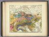
Geologische Karte von Deutschland und den anlieg.
1 : 4600000 Berghaus, Heinrich
[Fluss- u. Berg-Karte von Deutschland und den anlieg. Ländern]
Hand-Atlas über alle Theile der Erde nach dem neuesten Zustande und über das Weltgebäude Stieler, Adolf bei Justus Perthes
[Fluss- u. Berg-Karte von Deutschland und den anlieg. Ländern]
Hand-Atlas über alle Theile der Erde nach dem neuesten Zustande und über das Weltgebäude Stieler, Adolf bei Justus Perthes
Fluss- und Bergkarte von Deutschland und den anliegenden Ländern
Handatlas über alle Theile der Erde und über das Weltgebäude Stieler, Adolf Justus Perthes
Fluss Und Bergkarte Von Deutschland Und Den Anliegenden Landern.
1 : 4625000 Berghaus, Hermann
Fluss und Bergkarte von Deutschland und den anliegenden Ländern
Hand-Atlas über alle Theile der Erde und über das Weltgebäude Stieler, Adolf Justus Perthes
Geologische Karte von Deutschland und anlieg. Ländern

Post- Reise-Karte durch Deutschland und die angraenzenden Staaten zwischen London und Lublin, Koppenhagen und Mantua
Evropa střední Schmidt, O. F. Schropp, Simon Simon Schropp & Comp.
Neueste Eisenbahn-Karte von Central-Europa
1 : 1900000 Evropa střední Hendschel, U. Carl Jügel
Mitteleuropa
1 : 3500000 Evropa střední Köcher
Mitteleuropa am Ende des 30 jährigen Krieges
Evropa střední F. Tempsky
Deutschland
Allgemeiner Atlas [Walch, Johannes] im Verlag bei Johannes Walch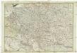
Neue und vollkomene Postkarte durch ganz Teutschland
1 : 2100000 Evropa jihovýchodní bey Artaria
Neue und vollkomene Postkarte durch ganz Teutschland
1 : 2100000 Evropa jihovýchodní Artaria
Mitteleuropa während des 30 jährigen Krieges.
Evropa střední Benecke Bormann, E. F. Tempsky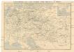
Eisenbahn-Routen-Karte von Mittel-Europa
Evropa střední Ritter, Julius R. v. Waldheim
Deutschland
mapa VKOL Petermann, August Justus Perthes
Deutschland
mapa VKOL Petermann, August Justus Perthes
Hendschel's Post u. Reise Karte von Deutschland und den Nachbar-Staaten bis London, Paris, Montpellier, Florenz, Warschau, Kopenhagen &
Evropa střední Hendschel, U. Back, Jean Conr.
Fluss- und Gebirgs-Karte von Mittel-Eüropa
1 : 4900000 Evropa střední Handtke, Friedrich C. Flemming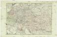
Neue und vollkomene Postkarte durch ganz Deutschland
Florencie (Itálie) Mansfeld, Johann Ernst Artaria & Co.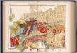
Mitteleuropa, Geologische Übersicht
1 : 3500000 Scobel, Albert
Sbírka map a diagramů použitých na mírových konferencích v Paříži v letech 1919 - 1920
Neueste Post-Karte von Deutschland und demgrösten Theil der umliegenden Staaten oder Mitter-Europa
1 : 2340000 Evropa střední Fried, Franz List, Joseph bey Artaria et Compagnie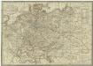
Neueste Post-Karte von Deutschland und dem grösten Theil der umliegenden Staaten oder Mittel-Europa
1 : 2350000 Evropa střední Fried, Franz List, C. Artaria
Eisenbahnkarte von Mittel-Europa
1 : 2560000 Evropa střední
![[Fluss- u. Berg-Karte von Deutschland und den anlieg. Ländern]](https://images-0.georeferencer.com/images/iiif/905550393746/full/,300/0/native.jpg)

