Maps of Tower Hamlets

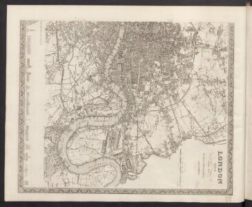
London
Grosser Hand-Atlas über alle Theile der Erde in 170 Karten Meyer, J. Verlag des Bibliographischen Instituts
Plan showing the sewers in Tower Hamlets, 1843
From 1807, the East End was supplied with water pumped from the River Lea at Bow by the East London Waterworks Company. This was not, however, the continuous flow of water we take for granted today. Dr John Simon wrote, in 1849, of the thousands who "wholly depend on their power of attending at some fixed hour of the day, pail in hand, beside the nearest standcock; where, with their neighbours, they wait their turn; sometimes not without a struggle, during the tedious dribbling of a single small pipe. Household rubbish was piled into heaps in the street and outdoor toilets drained into cesspits. The survey of sanitation in Bethnal Green made by Hector Gavin in 1848 paints a sorry picture. Knightly Court was typical of the streets he visited: "In it there are two privies in a beastly state, full, and the contents overflowing into the court. There is one dust reservoir. One stand-tap supplies the seven houses; two cases of severe typhus lately occurred here, one died." This map of 1843 shows the distribution of sewers through the East End. They carried only surface water, contaminated with decayed rubbish from the streets and excrement from overflowing cesspits, and discharged it directly into the Thames - from which water companies pumped their drinking water. James Beek
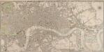
Rowe's map of London, westminster and Southwark, exhibiting the various improvements to the year 1804, detail showing the London and west india Docks
A canal and the two West India docks now cut across the neck of the Isle of Dogs to provide shipping with a shortcut across its marshy peninsular. A wall around its edge holds back the tidal Thames while windmills on the windy west side pump water from the marsh. As industry spreads, wealthy residents are lured away to the fashionable new suburbs rising to the west of London. Turnpikes appear, on the Hackney Road for example: an indication of the growing need for good roads and the money to maintain them. From the tangle of older streets, the line of the proposed new Commercial Road shoots straight across the open fields. Rowe
LONDON AND WESTMINSTER with the Borough of SOUTHWARK Being an INDEX to the Large Plan in forty sheets 231
The title, explanatory notesand scale bar of this folding mapappear at top right. The map is divided into squares, with letters and numbers for referencealong the margins. A key appears in a panel below the plan. Originally published by Faden in 1818 as an index to Harwood's famous map of Regency London,the map was reissued by James Wyld when he took over Faden's publishing business in the late 1820s. Faden, William
PLAN OF LONDON AND WESTMINSTER with the Borough of SOUTHWARK Being an INDEX to the Large Plan in forty Sheets
This folding map of London was originally published by Faden in 1818 as an index to Harwood's famous map of Regency London. This is a later edition of the map, issued by Wyld when he took over Faden's publishing business. The title, explanation and scale bar feature at top right. The boundaries of London, Westminster, Southwark, Lambeth, Marylebone, Finsbury and Tower Hamlets are outlined in colour. The map is divided into squares with letters and numbers for reference along the margins for reference, with an interpretive key in panel below the plan. Faden, William
FAIRBURN'S PLAN of the proposed WET-DOCKS AND CUT from NEW GRAVEL LANE to BLACKWALL
1 : 16896 The plan's title and publisher's imprint appear at bottom left, with a compass star, key and scale bar at bottom centre.The boundary of the area to be developed is highlighted in red. After a Parliamentary Select Committee in 1796 condemned the congestion at the Port of London, a number of large-scale projects for new docking and shipping facilities were submitted to Parliament. Fairburn's plan illustrates the London merchants' scheme. It consists of an entrance dock that could accommodate 33 loaded ships, two main docks that would accommodate a total of 355 ships and a separate dock for lighters. The plan also included the creation of the 2" 3/4 mile long cut from Wapping to Blackwall. An improved version of this scheme would eventually materialise as the London Docks. Fairburn, John
LONDON AND WESTMINSTER with the Borough of SOUTHWARK Being an INDEX to the Large Plan in forty sheets 219
This folding map of London was originally published as the index to Harwood's famous map of Regency London. The map features the title, imprint and scale bar at the top right and is divided into squares, with letters and numbers along the borders for reference. Faden, William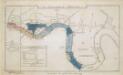
The Merchants' Plan of the London Docks, by D. Alexander, 1796; with the Stations for Ships in the River
CRUCHLEY'S NEW PLAN OF LONDON IMPROVED TO 1826 INCLUDING THE EAST AND WEST INDIA DOCKS 223
The title of this folding map of London is inset in top border, with the publisher’s imprint and key to symbols in bottom border, scale bar near bottom right, and compass rose at top right. The river and open spaces are highlighted in colour. The map extends eastward on an added sheet to include the East and West India Docks. Cruchley, who first published the map in 1826, added the proposed Collier Docks in the Isle of Dogs to this later edition. The docks were never built and Millwall Docks now occupy part of the site Cruchley, George Frederick
CRUCHLEY'S NEW PLAN OF LONDON IMPROVED TO 1826 INCLUDING THE EAST AND WEST INDIA DOCKS 226
The title of this folding map of London appears inset in the top border, with the publisher’s imprint and key to symbols in the bottom border, the scale bar near the bottom right, and a compass rose at the top right. The river and open spaces are distinguished in colour. The map extends eastward on an added sheet to include the Isle of Dogs and the East and West India Docks. Cruchley, George Frederick
London surveyed or a new map of the cities of London and Westminster and the borough of Southwark. ...
from The world described, or, A new and correct sett of maps : shewing the kingdoms and states in all the known parts of the earth, with the principal cities, and most considerable towns in the world ... / ... by Herman Moll, geographer ...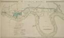
The LONDON DOCKS
1 : 14080 This is Daniel Alexanders original design for the London Docks and Cut. The plan's title and key are at lower left, with the site of the new docks highlighted in blue. Alexander's original design included a 20-acre St. Georges Dock to the west and a seven-acre Shadwell Dock to the east. Each would have their own basin, and be linked by a small Tobacco Dock. Opened in 1805, London Docks were the nearest to the city, and for 21 years all imported tobacco, rice, wine and brandy (except that from the East and West Indies) had to unload there. Alexander, Daniel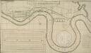
A PROPOSED PLAN FOR WET DOCKS IN WAPPING &c.
1 : 8175 Proposed plan for wet docks at Wapping, with title along the top, key at bottom right, tide table for Blackwall at bottom centre and inset plan of docking and storage facilities at bottom left. This was one of many large scale plans for new docking and shipping facilities for London submitted to Parliament after a Parliamentary Committee reported on the congestion and inadequacy of the London port in 1796. Walker, Ralph
An Actuall Survey of the Parish of St Dunstan Stepney alias Stebunheath ... Taken ... 1703 by Ioel Gascoyne, engraven by Iohn Harris. A scale of 1320 yards[ = 9 inches]

PLAN SHEWING THE PROPOSED LINE of the LONDON AND GREENWICH RAILWAY
1 : 7200 The title of this plan appears at bottom left, with an explanatory note and scale bar at bottom centre. An illustration of the general construction of the railway features at bottom right. The Greenwich line reached Bermondsey in 1836. A year later, it reached London Bridege, which became the first railway terminus in the capital. Wyld, James
Charles Booth's 'Descriptive Map of London Poverty'. Detail showing the City of London and the East End
The East End of London is the hell of poverty. Like one enormous black, motionless giant kraken, the poverty of London lies there in lurking silence and encircles with its mighty tentacles the life and wealth of the City. So wrote J H Mackay in 1891. It was acknowledged that the blame lay with overcrowded housing and with a surplus of labour, which kept wages low for those lucky enough to find work. Statistics for 1888 showed that the East End had 8,465 official paupers - people 'living rough'. According to Charles Booth's survey in 1889, over a third of its inhabitants lived on or below the margin of poverty. His 17-volume survey included this coloured-coded map indicating London's poverty and prosperity street by street. The key to the colours used is as follows: Gold: Upper-middle and Upper classes.Wealthy. Red: Well-to-do. Middle-class. Pink: Fairly comfortable. Good ordinary earning. Purple: Mixed. Some comfortable, others poor. Pale Blue: Poor. 18s. to 21s. a week for moderate family Dark blue: Very poor, casual. Chronic want. Black: Lowest class. Vicious, semi-criminal. Booth, Charles
Newcourt's 'Map of London', detail showing the East End
Richard Newcourt’s map, made in 1658, represents the first complete survey of London since the 1550s. It shows the City and its surrounding countryside in the closing years of the Commonwealth. Though most buildings are depicted in a conventionalised way, the map gives some idea of the actual appearance of more important places, such as churches and livery halls. The inclusion of their coats of arms in the map's decoration suggests the Livery Companies may have commissioned Newcourt's work. The map provides a fairly accurate picture of the development of the City's eastern suburbs, already spreading along the roads that reached out across the countryside towards the surrounding villages. As well as being the docklands of London, this was the area where the first native English school of chartmaking, the so-called 'Thames School', was getting underway at the very time this map was made. Newcourt, Richard
London NE.
1 : 15840 Stanford, Edward
Essex LXXIII.SW - OS Six-Inch Map
1 : 10560 Topographic maps Ordnance Survey Ordnance Survey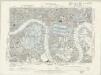
Essex LXXXI.NW - OS Six-Inch Map
1 : 10560 Topographic maps Ordnance Survey Ordnance Survey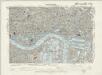
Surrey III.NE - OS Six-Inch Map
1 : 10560 Topographic maps Ordnance Survey Ordnance Survey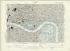
London VII.SE - OS Six-Inch Map
1 : 10560 Topographic maps Ordnance Survey Ordnance Survey
Zielgebeit II London
Der Oberbefehlshaber der Luftwaffe, Führungsstab IC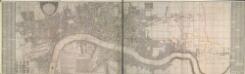
A New and Exact Plan of Ye City of LONDON and suburbs thereof, 1731 92
Map of London featuring title in semi-elliptical cartouche at top left, arms of the 12greatcity companies around the arms of the city at bottom left and explanatory note and compass star at bottom centre. The map is divided in squares with letters along the borders for reference. Reference tables feature down both sides of the map. Ward boundaries within the city and parish boundaries outside the city are highlighted in colour. The Tower of London, St Paul's Cathedral and other prominent buildings are represented pictorially. This is a later edition of the map first issued by Bowles in 1719, extended to the east to include Stepney and the Isle of Dogs. Bowles, Thomas
A NEW PLAN of the CITY of LONDON and BOROUGH OF SOUTHWARK, Exhibiting all the New Streets & Roads &c. Not extant in any other Plan.
1 : 14080 Thomas Jeffreys was an exceptional cartographer and publisher whose productions included maps of North America, considered to be among the finest of the time.This map of the City of London and the Borough of Southwark shows important buildings such as the Tower of London and St Paul's in plan form, differing from many earlier examples, which show them in elevation. It is dedicated to the Right Honourable Lord Mayor Aldermen and to the Commissioners of the Sewers, Lamps and Pavements. Jeffreys, Thomas
London
1 : 50000 Londýn (Anglie) Hollar, Václav Blome, Richard Ric. Blome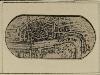
LONDON 19
The title of this miniature map of London features along the river. The map's orientation is reversed horizontally so that the west is represented on the right of the map.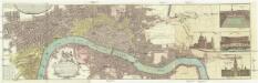
Vrbium Londini et West-Monasterii, nec non suburbii Southwark
1 : 6600 Londýn (Anglie) edita curis Homannianorum Heredum
Charles Booth's descriptive map of London poverty 1889
Charles Booth