Maps of Tower Hamlets

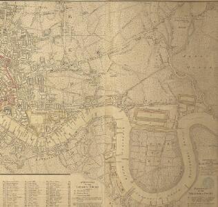
Rowe's map of London, westminster and Southwark, exhibiting the various improvements to the year 1804, detail showing the London and west india Docks
A canal and the two West India docks now cut across the neck of the Isle of Dogs to provide shipping with a shortcut across its marshy peninsular. A wall around its edge holds back the tidal Thames while windmills on the windy west side pump water from the marsh. As industry spreads, wealthy residents are lured away to the fashionable new suburbs rising to the west of London. Turnpikes appear, on the Hackney Road for example: an indication of the growing need for good roads and the money to maintain them. From the tangle of older streets, the line of the proposed new Commercial Road shoots straight across the open fields. Rowe
London
Grosser Hand-Atlas über alle Theile der Erde in 170 Karten Meyer, J. Verlag des Bibliographischen Instituts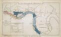
The Merchants' Plan of the London Docks, by D. Alexander, 1796; with the Stations for Ships in the River

FAIRBURN'S PLAN of the proposed WET-DOCKS AND CUT from NEW GRAVEL LANE to BLACKWALL
1 : 16896 The plan's title and publisher's imprint appear at bottom left, with a compass star, key and scale bar at bottom centre.The boundary of the area to be developed is highlighted in red. After a Parliamentary Select Committee in 1796 condemned the congestion at the Port of London, a number of large-scale projects for new docking and shipping facilities were submitted to Parliament. Fairburn's plan illustrates the London merchants' scheme. It consists of an entrance dock that could accommodate 33 loaded ships, two main docks that would accommodate a total of 355 ships and a separate dock for lighters. The plan also included the creation of the 2" 3/4 mile long cut from Wapping to Blackwall. An improved version of this scheme would eventually materialise as the London Docks. Fairburn, John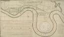
A PROPOSED PLAN FOR WET DOCKS IN WAPPING &c.
1 : 8175 Proposed plan for wet docks at Wapping, with title along the top, key at bottom right, tide table for Blackwall at bottom centre and inset plan of docking and storage facilities at bottom left. This was one of many large scale plans for new docking and shipping facilities for London submitted to Parliament after a Parliamentary Committee reported on the congestion and inadequacy of the London port in 1796. Walker, Ralph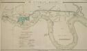
The LONDON DOCKS
1 : 14080 This is Daniel Alexanders original design for the London Docks and Cut. The plan's title and key are at lower left, with the site of the new docks highlighted in blue. Alexander's original design included a 20-acre St. Georges Dock to the west and a seven-acre Shadwell Dock to the east. Each would have their own basin, and be linked by a small Tobacco Dock. Opened in 1805, London Docks were the nearest to the city, and for 21 years all imported tobacco, rice, wine and brandy (except that from the East and West Indies) had to unload there. Alexander, Daniel
An Actuall Survey of the Parish of St Dunstan Stepney alias Stebunheath ... Taken ... 1703 by Ioel Gascoyne, engraven by Iohn Harris. A scale of 1320 yards[ = 9 inches]

Essex LXXXI.NW - OS Six-Inch Map
1 : 10560 Topographic maps Ordnance Survey Ordnance Survey
Surrey III.NE - OS Six-Inch Map
1 : 10560 Topographic maps Ordnance Survey Ordnance Survey
Newcourt's 'Map of London', detail showing the East End
Richard Newcourt’s map, made in 1658, represents the first complete survey of London since the 1550s. It shows the City and its surrounding countryside in the closing years of the Commonwealth. Though most buildings are depicted in a conventionalised way, the map gives some idea of the actual appearance of more important places, such as churches and livery halls. The inclusion of their coats of arms in the map's decoration suggests the Livery Companies may have commissioned Newcourt's work. The map provides a fairly accurate picture of the development of the City's eastern suburbs, already spreading along the roads that reached out across the countryside towards the surrounding villages. As well as being the docklands of London, this was the area where the first native English school of chartmaking, the so-called 'Thames School', was getting underway at the very time this map was made. Newcourt, Richard
Kent I.NE - OS Six-Inch Map
1 : 10560 Topographic maps Ordnance Survey Ordnance Survey
Zielgebeit II London
Der Oberbefehlshaber der Luftwaffe, Führungsstab IC
Essex LXXIII.SW - OS Six-Inch Map
1 : 10560 Topographic maps Ordnance Survey Ordnance Survey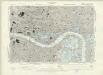
London VII.SE - OS Six-Inch Map
1 : 10560 Topographic maps Ordnance Survey Ordnance Survey
PLAN SHEWING THE PROPOSED LINE of the LONDON AND GREENWICH RAILWAY
1 : 7200 The title of this plan appears at bottom left, with an explanatory note and scale bar at bottom centre. An illustration of the general construction of the railway features at bottom right. The Greenwich line reached Bermondsey in 1836. A year later, it reached London Bridege, which became the first railway terminus in the capital. Wyld, James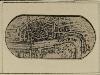
LONDON 19
The title of this miniature map of London features along the river. The map's orientation is reversed horizontally so that the west is represented on the right of the map.
Handy Reference Atlas of London
Edinburgh : John Bartholomew & Co.,
The Jew in London. A study of racial character and present-day conditions.
Arkill, G.E. T. Fisher Unwin
Vrbium Londini et West-Monasterii nec non suburbii Southwark accurata ichnographia, 3
1 Blatt : 53 x 57 cm Homännische Erben
Insurance Plan of London Vol. xi: Key Plan 3
1 : 960 This "key plan" indicates coverage of the Goad 1891 series of fire insurance maps of London that were originally produced to aid insurance companies in assessing fire risks. The building footprints, their use (commercial, residential, educational, etc.), the number of floors and the height of the building, as well as construction materials (and thus risk of burning) and special fire hazards (chemicals, kilns, ovens) were documented in order to estimate premiums. Names of individual businesses, property lines, and addresses were also often recorded. Together these maps provide a rich historical shapshot of the commercial activity and urban landscape of towns and cities at the time. The British Library holds a comprehensive collection of fire insurance plans produced by the London-based firm Charles E. Goad Ltd. dating back to 1885. These plans were made for most important towns and cities of the British Isles at the scales of 1:480 (1 inch to 40 feet), as well as many foreign towns at 1:600 (1 inch to 50 feet). Chas E Goad Limited Chas E Goad Limited
Insurance Plan of London: sheet 8
This detailed 1889 plan of London is one of a series of six sheets in an atlas originally produced to aid insurance companies in assessing fire risks. The building footprints, their use (commercial, residential, educational, etc.), the number of floors and the height of the building, as well as construction materials (and thus risk of burning) and special fire hazards (chemicals, kilns, ovens) were documented in order to estimate premiums. Names of individual businesses, property lines, and addresses were also often recorded. Together these maps provide a rich historical shapshot of the commercial activity and urban landscape of towns and cities at the time. The British Library holds a comprehensive collection of fire insurance plans produced by the London-based firm Charles E. Goad Ltd. dating back to 1885. These plans were made for most important towns and cities of the British Isles at the scales of 1:480 (1 inch to 40 feet), as well as many foreign towns at 1:600 (1 inch to 50 feet). Chas E Goad Limited Chas E Goad Limited
A new and exact plan of the city of London and suburbs thereof, 3
1 Blatt : 58 x 50 cm Henry Overton
THE SURREY & KENT COMMERCIAL ROADS from the KINGS YARD DEPTFORD, EAST COUNTRY AND COMMERCIAL DOCKS to the Bricklayers Arms, Kent Road & TOOLEY STREET
1 : 7920 Plan for laying down new roads connecting the docks in Deptford to Tooley Street in Bermondsey. The plan is oriented with south at the top and features title and scale bar at lower left and key to colour at top left.
Insurance Plan of London: sheet 4
This detailed 1889 plan of London is one of a series of six sheets in an atlas originally produced to aid insurance companies in assessing fire risks. The building footprints, their use (commercial, residential, educational, etc.), the number of floors and the height of the building, as well as construction materials (and thus risk of burning) and special fire hazards (chemicals, kilns, ovens) were documented in order to estimate premiums. Names of individual businesses, property lines, and addresses were also often recorded. Together these maps provide a rich historical shapshot of the commercial activity and urban landscape of towns and cities at the time. The British Library holds a comprehensive collection of fire insurance plans produced by the London-based firm Charles E. Goad Ltd. dating back to 1885. These plans were made for most important towns and cities of the British Isles at the scales of 1:480 (1 inch to 40 feet), as well as many foreign towns at 1:600 (1 inch to 50 feet). Chas E Goad Limited Chas E Goad Limited
Insurance Plan of London Vol. V: Key Plan 3
1 : 480 This detailed 1887 plan of London is one of a series of twenty-five sheets in an atlas originally produced to aid insurance companies in assessing fire risks. The building footprints, their use (commercial, residential, educational, etc.), the number of floors and the height of the building, as well as construction materials (and thus risk of burning) and special fire hazards (chemicals, kilns, ovens) were documented in order to estimate premiums. Names of individual businesses, property lines, and addresses were also often recorded. Together these maps provide a rich historical shapshot of the commercial activity and urban landscape of towns and cities at the time. The British Library holds a comprehensive collection of fire insurance plans produced by the London-based firm Charles E. Goad Ltd. dating back to 1885. These plans were made for most important towns and cities of the British Isles at the scales of 1:480 (1 inch to 40 feet), as well as many foreign towns at 1:600 (1 inch to 50 feet). Chas E Goad Limited Chas E Goad Limited
Insurance Plan of London Vol. xi Regent's Canal and Vicinity: Key Plan 3
1 : 4800 This "key plan" indicates coverage of the Goad 1891 series of fire insurance maps of London that were originally produced to aid insurance companies in assessing fire risks. The building footprints, their use (commercial, residential, educational, etc.), the number of floors and the height of the building, as well as construction materials (and thus risk of burning) and special fire hazards (chemicals, kilns, ovens) were documented in order to estimate premiums. Names of individual businesses, property lines, and addresses were also often recorded. Together these maps provide a rich historical shapshot of the commercial activity and urban landscape of towns and cities at the time. The British Library holds a comprehensive collection of fire insurance plans produced by the London-based firm Charles E. Goad Ltd. dating back to 1885. These plans were made for most important towns and cities of the British Isles at the scales of 1:480 (1 inch to 40 feet), as well as many foreign towns at 1:600 (1 inch to 50 feet). Chas E Goad Limited Chas E Goad Limited
Insurance Plan of London Vol. XI: Key Plan
1 : 4800 This "key plan" indicates coverage of the Goad 1890 series of fire insurance maps of London that were originally produced to aid insurance companies in assessing fire risks. The building footprints, their use (commercial, residential, educational, etc.), the number of floors and the height of the building, as well as construction materials (and thus risk of burning) and special fire hazards (chemicals, kilns, ovens) were documented in order to estimate premiums. Names of individual businesses, property lines, and addresses were also often recorded. Together these maps provide a rich historical shapshot of the commercial activity and urban landscape of towns and cities at the time. The British Library holds a comprehensive collection of fire insurance plans produced by the London-based firm Charles E. Goad Ltd. dating back to 1885. These plans were made for most important towns and cities of the British Isles at the scales of 1:480 (1 inch to 40 feet), as well as many foreign towns at 1:600 (1 inch to 50 feet). Chas E Goad Limited Chas E Goad Limited
Insurance Plan of London East District Vol. G: sheet D
1 : 3600 This detailed 1900 plan of London is one of a series of thirty-five sheets in an atlas originally produced to aid insurance companies in assessing fire risks. The building footprints, their use (commercial, residential, educational, etc.), the number of floors and the height of the building, as well as construction materials (and thus risk of burning) and special fire hazards (chemicals, kilns, ovens) were documented in order to estimate premiums. Names of individual businesses, property lines, and addresses were also often recorded. Together these maps provide a rich historical shapshot of the commercial activity and urban landscape of towns and cities at the time. The British Library holds a comprehensive collection of fire insurance plans produced by the London-based firm Charles E. Goad Ltd. dating back to 1885. These plans were made for most important towns and cities of the British Isles at the scales of 1:480 (1 inch to 40 feet), as well as many foreign towns at 1:600 (1 inch to 50 feet). Chas E Goad Limited Chas E Goad Limited
Insurance Plan of London East District Vol. G: sheet C
1 : 480 This detailed 1900 plan of London is one of a series of thirty-five sheets in an atlas originally produced to aid insurance companies in assessing fire risks. The building footprints, their use (commercial, residential, educational, etc.), the number of floors and the height of the building, as well as construction materials (and thus risk of burning) and special fire hazards (chemicals, kilns, ovens) were documented in order to estimate premiums. Names of individual businesses, property lines, and addresses were also often recorded. Together these maps provide a rich historical shapshot of the commercial activity and urban landscape of towns and cities at the time. The British Library holds a comprehensive collection of fire insurance plans produced by the London-based firm Charles E. Goad Ltd. dating back to 1885. These plans were made for most important towns and cities of the British Isles at the scales of 1:480 (1 inch to 40 feet), as well as many foreign towns at 1:600 (1 inch to 50 feet). Chas E Goad Limited Chas E Goad Limited
London (1915- Numbered sheets) V.8 (includes: Bethnal Green; Hackney; Poplar Borough; Stepney) - 25 Inch Map
1 : 2500 Topographic maps Ordnance Survey Ordnance Survey
London (Edition of 1894-96) LII (includes: Bethnal Green; Hackney; Poplar Borough; Stepney) - 25 Inch Map
1 : 2500 Topographic maps Ordnance Survey Ordnance Survey